Woodland, Minnesota

Last updated
Woodland
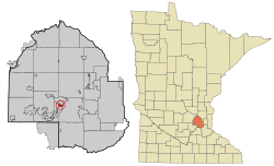
Hennepin County Minnesota Incorporated and Unincorporated areas Woodland Highlighted.svg
Location of Woodland
within Hennepin County, Minnesota
Coordinates: 44°57′6″N93°30′32″W / 44.95167°N 93.50889°W / 44.95167; -93.50889 Coordinates: 44°57′6″N93°30′32″W / 44.95167°N 93.50889°W / 44.95167; -93.50889
Country United States
State Minnesota
County Hennepin
Incorporated1948
Government
  MayorVince Suerth
Area
[1]
  Total1.17 sq mi (3.02 km2)
  Land0.58 sq mi (1.49 km2)
  Water0.59 sq mi (1.53 km2)
Elevation
951 ft (290 m)
Population
 (2020)
  Total384
  Density666.67/sq mi (257.50/km2)
Time zone UTC-6 (Central (CST))
  Summer (DST) UTC-5 (CDT)
ZIP code
55391
Area code 952
FIPS code 27-71500 [2]
GNIS feature ID0654355 [3]
Website www.cityofwoodlandmn.org

Woodland is a community in Hennepin County, Minnesota, United States, with lake shore property on Lake Minnetonka. The population was 437 at the 2010 census. [4] The first settlers arrived in 1857, when Woodland was part of Minnetonka Township. The land was formally platted in 1882 and developed through the 1890s. Woodland was incorporated as the independent village of Maplewoods in December 1948. It was renamed "Woodland" in 1949. [5]

Contents

Geography

According to the United States Census Bureau, the city has a total area of 0.62 square miles (1.61 km2), of which 0.58 square miles (1.50 km2) is land and 0.04 square miles (0.10 km2) is water. [6] County 101 serves as a main route.

Demographics

Historical population
CensusPop.
1950 411
1960 4499.2%
1970 54421.2%
1980 526−3.3%
1990 496−5.7%
2000 480−3.2%
2010 437−9.0%
2020 384−12.1%
U.S. Decennial Census [7]

2010 census

As of the census [8] of 2010, there were 437 people, 169 households, and 138 families living in the city. The population density was 753.4 inhabitants per square mile (290.9/km2). There were 189 housing units at an average density of 325.9 per square mile (125.8/km2). The racial makeup of the city was 98.2% White, 0.2% African American, 0.5% Asian, 0.2% from other races, and 0.9% from two or more races. Hispanic or Latino of any race were 2.3% of the population.

There were 169 households, of which 29.6% had children under the age of 18 living with them, 74.6% were married couples living together, 4.7% had a female householder with no husband present, 2.4% had a male householder with no wife present, and 18.3% were non-families. 16.0% of all households were made up of individuals, and 7.1% had someone living alone who was 65 years of age or older. The average household size was 2.59 and the average family size was 2.89.

The median age in the city was 51.8 years. 22.9% of residents were under the age of 18; 4.9% were between the ages of 18 and 24; 11.4% were from 25 to 44; 41.9% were from 45 to 64; and 18.8% were 65 years of age or older. The gender makeup of the city was 49.7% male and 50.3% female.

2000 census

As of the census [2] of 2000, there were 480 people, 173 households, and 144 families living in the city. The population density was 840.7 inhabitants per square mile (324.6/km2). There were 188 housing units at an average density of 329.3 per square mile (127.1/km2). The racial makeup of the city was 97.71% White, 0.42% Asian, 0.62% from other races, and 1.25% from two or more races. Hispanic or Latino of any race were 1.04% of the population.

There were 173 households, out of which 38.7% had children under the age of 18 living with them, 76.3% were married couples living together, 5.8% had a female householder with no husband present, and 16.2% were non-families. 13.3% of all households were made up of individuals, and 4.0% had someone living alone who was 65 years of age or older. The average household size was 2.77 and the average family size was 3.06.

In the city, the population was spread out, with 28.1% under the age of 18, 5.0% from 18 to 24, 18.3% from 25 to 44, 36.7% from 45 to 64, and 11.9% who were 65 years of age or older. The median age was 44 years. For every 100 females, there were 92.8 males. For every 100 females age 18 and over, there were 93.8 males.

The median income for a household in the city was $153,881, and the median income for a family was $175,000. Males had a median income of $100,000 versus $46,250 for females. The per capita income for the city was $95,495. About 3.8% of families and 4.6% of the population were below the poverty line, including 6.4% of those under age 18 and none of those age 65 or over.
Politics

Presidential election results
Precinct General Election Results [9]
Year Republican Democratic Third parties
2020 48.8% 15949.7%1621.5% 5
2016 47.8%15141.8% 13210.4% 33
2012 63.3%21935.8% 1240.9% 3
2008 53.5%18545.4% 1571.1% 4
2004 60.3%20738.2% 1311.5% 5
2000 65.1%20729.6% 945.3% 17
1996 64.5%17828.3% 787.2% 20
1992 54.6%18024.2% 8021.2% 70
1988 75.8%24124.2% 770.0% 0
1984 78.2%24811.8% 690.0% 0
1980 69.3%24117.2% 6013.5% 47
1976 78.5%26320.0% 671.5% 5
1972 75.3%24724.4% 801.3% 1
1968 77.9%23320.4% 611.7% 5
1964 71.7%19028.3% 750.0% 0
1960 83.0%21416.3% 420.7% 2
1956 82.4%19217.6% 410.0% 0

Related Research Articles

<span class="mw-page-title-main">Woodland, Georgia</span> City in Georgia, United States

Woodland is a city in Talbot County, Georgia, United States. The population was 408 at the 2010 census.

<span class="mw-page-title-main">Woodland Hills, Kentucky</span> City in Kentucky, United States

Woodland Hills is a home rule-class city in Jefferson County, Kentucky, United States. The population was 696 at the 2010 census.

<span class="mw-page-title-main">Woodland, Michigan</span> Village in Michigan, United States

Woodland is a village in Barry County of the U.S. state of Michigan. The population was 425 at the 2010 census. The village is located within Woodland Township.

Woodland Township is a civil township of Barry County in the U.S. state of Michigan. The population was 2,047 at the 2010 census. The village of Woodland is located within the township.

<span class="mw-page-title-main">Deephaven, Minnesota</span> Incorporated community in Minnesota, United States

Deephaven is a small city in Hennepin County, Minnesota, United States. The community is located on Lake Minnetonka. The community’s center is the historic Cottagewood General Store, which has been serving the Lake Minnetonka area since 1895. It is located 14 miles (23 km) west-southwest of downtown Minneapolis. The population was 3,642 as of the 2010 Census, down from 3,853 as of the 2000 census.

<span class="mw-page-title-main">Greenwood, Minnesota</span> City in Minnesota, United States

Greenwood is a community on Saint Albans Bay on Lake Minnetonka in Hennepin County, Minnesota, United States just northeast of the community of Excelsior, Minnesota. The population was 688 at the 2010 census.

<span class="mw-page-title-main">Medina, Minnesota</span> City in Minnesota, United States

Medina is a city in Hennepin County, Minnesota, United States. An outer edge suburb of Minneapolis–Saint Paul, the city has a primarily rural character, with agricultural lands and natural preservation areas. Medina is home to the corporate headquarters of Polaris Inc., an automotive manufacturer that produces items such as all-terrain vehicles and snowmobiles.

<span class="mw-page-title-main">Minnetonka Beach, Minnesota</span> City in Minnesota, United States

Minnetonka Beach is a community in Hennepin County, Minnesota, United States. The population was 539 at the 2010 census.

<span class="mw-page-title-main">Minnetrista, Minnesota</span> City in Minnesota, United States

Minnetrista is a city in Hennepin County, Minnesota, United States. Largely rural, Minnetrista has agricultural activity involving corn, soybeans, hay and horses. In addition to farmland and woods, the city is home to several lakes, including part of Lake Minnetonka, the state's ninth-biggest.

<span class="mw-page-title-main">Mound, Minnesota</span> City in Minnesota, United States

Mound is a city in western Hennepin County, Minnesota, United States. The population was 9,052 at the 2010 census. Mound was the birthplace of the Tonka truck that is named after Lake Minnetonka, which the eastern part of town sits on. Mound is 22 miles (35 km) west of Minneapolis, the county seat.

<span class="mw-page-title-main">Shorewood, Minnesota</span> City in Minnesota, United States

Shorewood is a city nestled in the woods along on the shores of Lake Minnetonka in Hennepin County, Minnesota, United States. The population was 7,307 at the 2010 census. The city was incorporated in 1956. Its area was originally part of the former Excelsior Township.

<span class="mw-page-title-main">Tonka Bay, Minnesota</span> City in Minnesota, United States

Tonka Bay is a city in Hennepin County, Minnesota, United States. It is located on Lake Minnetonka between the upper and lower lakes. It gained some popularity in the 1880s and 1890s as a summer lake resort. The population of Tonka Bay was 1,475 at the 2010 census.

<span class="mw-page-title-main">Bluffton, Minnesota</span> City in Minnesota, United States

Bluffton is a city in Otter Tail County, Minnesota, United States, along the Leaf River. The population was 210 at the 2020 census.

Woodland Township is a township in Wright County, Minnesota, United States. The population was 1,137 at the 2000 census.

<span class="mw-page-title-main">Fort Calhoun, Nebraska</span> City in Nebraska, United States

Fort Calhoun is a city in Washington County, Nebraska, United States. The population was 908 at the 2010 census. The city includes Fort Atkinson, the first fort built west of the Missouri River.

<span class="mw-page-title-main">Spring Park, Minnesota</span> City in Minnesota, United States

Spring Park is a small city nestled on the shores of Lake Minnetonka in Hennepin County, Minnesota, United States and is about 20 miles west of Minneapolis. The population was 1,669 at the 2010 census.

<span class="mw-page-title-main">Clarkson Valley, Missouri</span> City in Missouri, United States

Clarkson Valley is a city in St. Louis County, Missouri, United States. The population was 2,609 at the 2020 census.

<span class="mw-page-title-main">Bradford Township, Clearfield County, Pennsylvania</span> Township in Pennsylvania, United States

Bradford Township is a township in Clearfield County, Pennsylvania, United States. The population was 2,847 at the 2020 census.

<span class="mw-page-title-main">Woodland Hills, Utah</span> City in Utah, United States

Woodland Hills is a city in Utah County, Utah, United States. It is part of the Provo–Orem Metropolitan Statistical Area. The population was 1,521 at the 2020 census. Woodland Hills became a city at the end of 2000.

<span class="mw-page-title-main">Woodland, Aroostook County, Maine</span> Town in the state of Maine, United States

Woodland is a town in Aroostook County, Maine, United States. The population was 1,217 at the 2020 census. Because the state of Maine has a law stating that no two towns may share the same name, Woodland of Aroostook County and Woodland of Washington County found themselves before the Maine Supreme Judicial Court in the late 1990s. Because it was founded as a township first, Woodland of Aroostook County was allowed to keep its name and Woodland of Washington County was ordered by the court to choose a new name: Baileyville.

References

  1. "2020 U.S. Gazetteer Files". United States Census Bureau. Retrieved July 24, 2022.
  2. 1 2 "U.S. Census website". United States Census Bureau . Retrieved 2008-01-31.
  3. "US Board on Geographic Names". United States Geological Survey. 2007-10-25. Retrieved 2008-01-31.
  4. "2010 Census Redistricting Data (Public Law 94-171) Summary File". American FactFinder. U.S. Census Bureau, 2010 Census. Retrieved 23 April 2011.[ dead link ]
  5. "Woodland History – City of Woodland MN".
  6. "US Gazetteer files 2010". United States Census Bureau . Retrieved 2012-11-13.
  7. "Census of Population and Housing". Census.gov. Retrieved June 4, 2015.
  8. "U.S. Census website". United States Census Bureau . Retrieved 2012-11-13.
  9. "Office of the Minnesota Secretary of State - Election Results".