Minnetonka Beach, Minnesota

Last updated • 3 min readFrom Wikipedia, The Free Encyclopedia

Minnetonka Beach
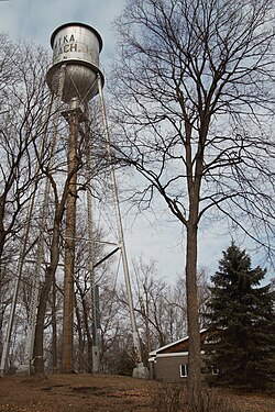
MinnetonkaBeachWaterTower.jpg
Minnetonka Beach Water Tower, a city landmark
Hennepin County Minnesota Incorporated and Unincorporated areas Minnetonka Beach Highlighted.svg
Location of Minnetonka Beach
within Hennepin County, Minnesota
Coordinates: 44°56′22″N93°35′30″W / 44.93944°N 93.59167°W / 44.93944; -93.59167
Country United States
State Minnesota
County Hennepin
Incorporated1894
Government
  MayorJoe Pagano [1]
Area
[2]
  Total1.54 sq mi (3.98 km2)
  Land0.47 sq mi (1.21 km2)
  Water1.07 sq mi (2.77 km2)
Elevation
942 ft (287 m)
Population
 (2020)
  Total546
  Density1,169.16/sq mi (451.07/km2)
Time zone UTC-6 (Central (CST))
  Summer (DST) UTC-5 (CDT)
ZIP code
55361
Area code 952
FIPS code 27-43270 [3]
GNIS feature ID0647950 [4]

Minnetonka Beach is a community in Hennepin County, Minnesota, United States. The population was 539 at the 2010 census. [5]

Contents

History

Minnetonka Beach is located on the shores of Lake Minnetonka. Originally part of Excelsior Township, Minnetonka Beach was the site of the Hotel Lafayette, which was built by the Minneapolis, Saint Paul, & Manitoba Railway (later part of the Great Northern Railway) in 1882. In 1884, Minnetonka Beach was annexed by Medina Township. The community was incorporated as an independent village in 1894. [6]

After the Hotel Lafayette burned in 1897, a portion of the property became home to the Lafayette Club. The original clubhouse of the Lafayette Club was built in 1900 and burned in 1922. The current clubhouse was constructed in 1924. [7]

Geography

According to the United States Census Bureau, the city has a total area of 0.48 square miles (1.24 km2), of which 0.47 square miles (1.22 km2) is land and 0.01 square miles (0.03 km2) is water. [8] County 15 serves as a main route.

Demographics

Historical population
CensusPop.Note
1900 101
1910 16664.4%
1920 94−43.4%
1930 11219.1%
1940 229104.5%
1950 37664.2%
1960 54444.7%
1970 5867.7%
1980 575−1.9%
1990 573−0.3%
2000 6147.2%
2010 539−12.2%
2020 5461.3%
U.S. Decennial Census

2010 census

As of the census [9] of 2010, there were 539 people, 201 households, and 159 families living in the city. The population density was 1,146.8 inhabitants per square mile (442.8/km2). There were 231 housing units at an average density of 491.5 per square mile (189.8/km2). The racial makeup of the city was 99.3% White, 0.4% Asian, and 0.4% from two or more races. Hispanic or Latino of any race were 0.6% of the population.

There were 201 households, of which 38.3% had children under the age of 18 living with them, 73.1% were married couples living together, 3.5% had a female householder with no husband present, 2.5% had a male householder with no wife present, and 20.9% were non-families. 18.9% of all households were made up of individuals, and 7% had someone living alone who was 65 years of age or older. The average household size was 2.68 and the average family size was 3.09.

The median age in the city was 46.7 years. 28.2% of residents were under the age of 18; 4.9% were between the ages of 18 and 24; 13.6% were from 25 to 44; 42.3% were from 45 to 64; and 10.9% were 65 years of age or older. The gender makeup of the city was 49.2% male and 50.8% female.

2000 census

As of the census [3] of 2000, there were 614 people, 215 households, and 176 families living in the city. The population density was 1,186.5 inhabitants per square mile (458.1/km2). There were 224 housing units at an average density of 432.8 per square mile (167.1/km2). The racial makeup of the city was 97.88% White, 0.16% Native American, 1.30% Asian, and 0.65% from two or more races.

There were 215 households, out of which 42.3% had children under the age of 18 living with them, 75.3% were married couples living together, 3.7% had a female householder with no husband present, and 17.7% were non-families. 14.4% of all households were made up of individuals, and 5.6% had someone living alone who was 65 years of age or older. The average household size was 2.86 and the average family size was 3.16.

In the city, the population was spread out, with 29.2% under the age of 18, 5.4% from 18 to 24, 20.7% from 25 to 44, 35.3% from 45 to 64, and 9.4% who were 65 years of age or older. The median age was 42 years. For every 100 females, there were 91.9 males. For every 100 females age 18 and over, there were 87.5 males.

The median income for a household in the city was $150,912, and the median income for a family was $168,868. Males had a median income of $100,000 versus $41,875 for females. The per capita income for the city was $91,844. About 1.8% of families and 2.7% of the population were below the poverty line, including 2.5% of those under age 18 and 16.7% of those age 65 or over.
Politics

Presidential election results 1960–2020
Precinct General Election Results [10]
Year Republican Democratic Third parties
2020 47.7% 20048.9%2053.4% 14
2016 50.3%18141.1% 1488.6% 31
2012 69.0%27630.5% 1220.5% 2
2008 57.0%22142.3% 1640.7% 3
2004 61.7%24537.5% 1490.8% 3
2000 66.3%25630.3% 1173.4% 13
1996 65.1%22227.9% 959.0% 24
1992 51.2%19423.5% 8925.3% 96
1988 73.2%28126.8% 1030.0% 0
1984 80.9%28419.1% 670.0% 0
1980 67.6%24818.0% 6614.4% 53
1976 73.3%25525.3% 881.4% 5
1972 71.7%24627.1% 931.2% 4
1968 73.2%23225.9% 820.9% 3
1964 76.1%23223.9% 730.0% 0
1960 83.2%24816.8% 500.0% 0

Related Research Articles

<span class="mw-page-title-main">Weippe, Idaho</span> City in Idaho, United States

Weippe is a city in Clearwater County, Idaho, United States. The population was 441 at the 2010 census, up from 411 in 2000. In September 1805, the starving Lewis and Clark Expedition first met the Nez Perce on the Weippe Prairie, south of the city.

<span class="mw-page-title-main">Charlestown, Maryland</span> Town in Maryland, United States

Charlestown is a town in Cecil County, Maryland, United States. The population was 1,183 at the 2010 census.

<span class="mw-page-title-main">Deephaven, Minnesota</span> Incorporated community in Minnesota, United States

Deephaven is a small city in Hennepin County, Minnesota, United States. The community is located on Lake Minnetonka. The community’s center is the historic Cottagewood General Store, which has been serving the Lake Minnetonka area since 1895. It is located 14 miles (23 km) west-southwest of downtown Minneapolis. The population was 3,642 as of the 2010 Census, down from 3,853 as of the 2000 census.

<span class="mw-page-title-main">Greenwood, Minnesota</span> City in Minnesota, United States

Greenwood is a community on Saint Albans Bay on Lake Minnetonka in Hennepin County, Minnesota, United States just northeast of the community of Excelsior, Minnesota. The population was 688 at the 2010 census.

<span class="mw-page-title-main">Minnetrista, Minnesota</span> City in Minnesota, United States

Minnetrista is a city in Hennepin County, Minnesota, United States. It is located about 23 miles (37 km) west of Minneapolis. Although it is part of the Minneapolis–Saint Paul metropolitan area, the largely rural Minnetrista has agricultural activity involving corn, soybeans, hay, and horses. In addition to farmland and woods, the city is home to several lakes, including part of Lake Minnetonka, the state's ninth-biggest. The city's population was 6,384 at the 2010 census. Minnetrista's name originates in the Dakota language, in which minne means "water" and trista means "crooked".

<span class="mw-page-title-main">Mound, Minnesota</span> City in Minnesota, United States

Mound is a city in western Hennepin County, Minnesota, United States. The population was 9,052 at the 2010 census. Mound was the birthplace of the Tonka truck that is named after Lake Minnetonka, which the eastern part of town sits on. Mound is 22 miles (35 km) west of Minneapolis, the county seat.

<span class="mw-page-title-main">Orono, Minnesota</span> Rural city in Minnesota, United States

Orono is a city in Hennepin County, Minnesota, United States west of Minneapolis. Located on the north shore of Lake Minnetonka, Orono is one of the state's most upscale and wealthiest cities and also known for its sparse suburban character and abundant wildlife.

<span class="mw-page-title-main">Shorewood, Minnesota</span> City in Minnesota, United States

Shorewood is a city nestled in the woods along on the shores of Lake Minnetonka in Hennepin County, Minnesota, United States. The population was 7,307 at the 2010 census. The city was incorporated in 1956. Its area was originally part of the former Excelsior Township.

<span class="mw-page-title-main">Tonka Bay, Minnesota</span> City in Minnesota, United States

Tonka Bay is a city in Hennepin County, Minnesota, United States. It is on Lake Minnetonka between the upper and lower lakes. It gained some popularity in the 1880s and 1890s as a summer lake resort. The population was 1,475 at the 2010 census.

<span class="mw-page-title-main">Woodland, Minnesota</span> City in Minnesota, United States

Woodland is a community in Hennepin County, Minnesota, United States, with lake shore property on Lake Minnetonka. The population was 437 at the 2010 census. The first settlers arrived in 1857, when Woodland was part of Minnetonka Township. The land was formally platted in 1882 and developed through the 1890s. Woodland was incorporated as the independent village of Maplewoods in December 1948. It was renamed "Woodland" in 1949.

<span class="mw-page-title-main">Regal, Minnesota</span> City in Minnesota, United States

Regal is a city in northeast Kandiyohi County, Minnesota, United States, along the North Fork of the Crow River. The population was 43 at the 2020 census.

<span class="mw-page-title-main">Long Beach, Minnesota</span> City in Minnesota, United States

Long Beach is a city in Pope County, Minnesota, United States. The population was 338 at the 2020 census.

<span class="mw-page-title-main">Hoyt Lakes, Minnesota</span> City in Minnesota, United States

Hoyt Lakes is a city in Saint Louis County, Minnesota. The population was 2,020 at the time of the 2020 census.

<span class="mw-page-title-main">St. Rosa, Minnesota</span> City in Minnesota, United States

Saint Rosa is a city in Stearns County, Minnesota, United States. The population was 58 at the 2020 census. It is part of the St. Cloud Metropolitan Statistical Area.

<span class="mw-page-title-main">Lake Lafayette, Missouri</span> City in Missouri, United States

Lake Lafayette is a city in Lafayette County, Missouri, and is part of the Kansas City metropolitan area within the United States. The population was 327 at the 2010 census.

<span class="mw-page-title-main">Spring Park, Minnesota</span> City in Minnesota, United States

Spring Park is a city nestled on the shores of Lake Minnetonka in Hennepin County, Minnesota, United States and is about 20 miles west of Minneapolis. The population was 1,669 at the 2010 census.

<span class="mw-page-title-main">Grand Coulee, Washington</span> City in Washington, United States

Grand Coulee is a city in Grant County, Washington, United States. The population was 972 at the 2020 census.

<span class="mw-page-title-main">Fayette, Wisconsin</span> Town in Wisconsin, United States

Fayette is a town in Lafayette County, Wisconsin, United States. The population was 376 at the 2010 census. The unincorporated communities of Fayette and Yellowstone are located in the town.

<span class="mw-page-title-main">La Farge, Wisconsin</span> Village in Wisconsin, United States

La Farge is a village along the Kickapoo River in Vernon County, Wisconsin, United States. Its population was 730 at the 2020 census.

<span class="mw-page-title-main">Blackburn, Missouri</span> City in Missouri, United States

Blackburn is a city in Lafayette and Saline counties in the U.S. state of Missouri and is part of the Kansas City metropolitan area. The population was 224 at the 2020 census.

References

  1. http://www.ci.minnetonka-beach.mn.us/index.asp?Type=B_BASIC&SEC={299CDA02-43F4-40B0-8C07-72B030812703}&DE={175DEC60-03E2-43FC-9516-5FE9713D0719} [ bare URL ]
  2. "2020 U.S. Gazetteer Files". United States Census Bureau. Retrieved July 24, 2022.
  3. 1 2 "U.S. Census website". United States Census Bureau . Retrieved January 31, 2008.
  4. "US Board on Geographic Names". United States Geological Survey. October 25, 2007. Retrieved January 31, 2008.
  5. "2010 Census Redistricting Data (Public Law 94-171) Summary File". American FactFinder. U.S. Census Bureau, 2010 Census. Retrieved April 23, 2011.[ dead link ]
  6. Johnson, Fred. The Big Water. Deep Haven Books, 2012. Pg. 122
  7. "Minnehaha's Connection to History (3/4) – Steamboat Minnehaha".
  8. "US Gazetteer files 2010". United States Census Bureau. Archived from the original on January 25, 2012. Retrieved November 13, 2012.
  9. "U.S. Census website". United States Census Bureau . Retrieved November 13, 2012.
  10. "Office of the Minnesota Secretary of State - Election Results". Archived from the original on February 22, 2021. Retrieved February 22, 2021.

44°56′23″N93°34′36″W / 44.93972°N 93.57667°W / 44.93972; -93.57667