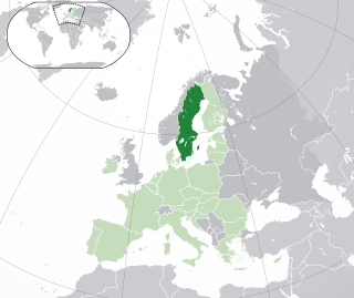
Sweden is a country in Northern Europe on the Scandinavian Peninsula. It borders Norway to the west ; Finland to the northeast; and the Baltic Sea and Gulf of Bothnia to the south and east. At 450,295 km2 (173,860 sq mi), Sweden is the largest country in Northern Europe, the fifth largest in Europe, and the 55th largest country in the world.
Norrbotten County is the northernmost county or län of Sweden. It is also the largest county by land area, almost a quarter of Sweden's total area. It shares borders with Västerbotten County to the southwest, the Gulf of Bothnia to the southeast, the counties of Nordland and Troms in Norway to the northwest, and Lapland Province in Finland to the northeast.

Haparanda Municipality, is a municipality in Norrbotten County in northern Sweden. Its seat is located in Haparanda.

Haparanda is a locality and the seat of Haparanda Municipality in Norrbotten County, Sweden. It is adjacent to Tornio, Finland. Haparanda has a population of 9,166 inhabitants (2024).

Märket is a 3.3-hectare (8.2-acre) uninhabited skerry in the Baltic Sea shared by Sweden and Finland, with a lighthouse as its salient humanmade feature. Märket has been divided between the two countries since the Treaty of Fredrikshamn of 1809 defined the border between Sweden and Grand Duchy of Finland as going through the middle of the island. The Finnish side of the island is part of the Municipality of Hammarland and is the westernmost land point of Finland. The Swedish part of the island is itself divided by two counties of Sweden: Uppsala County and Stockholm County.
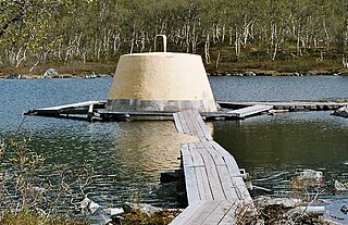
The Three-Country Cairn is the tripoint at which the international borders of Sweden, Norway and Finland meet, and the name of the monument that marks the point. It is the northernmost international tripoint in the world.

The Bothnian Bay or Bay of Bothnia is the northernmost part of the Gulf of Bothnia, which is in turn the northern part of the Baltic Sea. The land holding the bay is still rising after the weight of ice-age glaciers has been removed, and within 2,000 years the bay will be a large freshwater lake since its link to the south Kvarken is mostly less than 20 metres (66 ft) deep. The bay today is fed by several large rivers, and is relatively unaffected by tides, so has low salinity. It freezes over each year for up to six months. Compared to other parts of the Baltic, it has little plant or animal life.
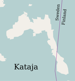
The Finland–Sweden border is the border between the countries of Finland and Sweden. Almost the entire border runs through water: along the Tornio River and its tributaries, and in the Gulf of Bothnia. Only a few kilometres of the border are on dry land. Because of the Schengen treaty and the Nordic Passport Union, the border can be crossed mostly freely.

Malören is an island in the Kalix archipelago of northern Sweden. It lies to the southwest of Sandskär, but is not part of the Haparanda Archipelago National Park. Malören has the shape of an atoll, with sandbanks around an inland sea. It came into existence about 1,500 years ago when the area began to rise by 85 cm (33 in) per century. Since 1997, the island has been a nature reserve, encompassing 181 ha. On the island is a chapel, built in 1769, and a lighthouse, built in 1851.
Seskar Furö is an uninhabited island in the northeast of the Swedish sector of the Bay of Bothnia. It is now part of a national park.
The Norrbotten archipelago is a group of Swedish islands in the north part of the Bay of Bothnia. A few of the islands have small permanent populations, but most are used only for recreation in the summer months. They are icebound during the winter.
The Kalix archipelago is a group of 792 Swedish islands in the north part of the Bay of Bothnia. The largest island in the Kalix archipelago is Rånön. A few of the islands have small permanent populations, but most are used only for recreation in the summer months. They are icebound during the winter.
The Haparanda archipelago is a group of 792 Swedish islands in the north part of the Bay of Bothnia. The islands are used for recreation in the summer months. They are icebound during the winter.
Hanhinkari is an island in the northeast of the Swedish sector of the Bothnian Bay, in the Haparanda archipelago.
Stora Hepokari is an island in the northeast of the Swedish sector of the Bothnian Bay, in the Haparanda archipelago.
Skomakaren is an island in the northeast of the Swedish sector of the Bothnian Bay, in the Haparanda archipelago.
Stora Hamnskär is an island in the northeast of the Swedish sector of the Bothnian Bay, in the Haparanda archipelago.
Torne-Furö is an island in the northeast of the Swedish sector of the Bothnian Bay, in the Haparanda archipelago.
Likskär is an island in the north of the Swedish sector of the Bay of Bothnia in the Kalix archipelago and a nature reserve that covers part of this and neighboring islands.