
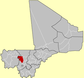
Koulikoro Region is a region in western Mali. It is the second administrative area of Mali and covers an area of 90,120 km2. Its capital is the city of Koulikoro.

Kati is an urban commune and the largest town in Mali's Koulikoro Region. The town is situated 15 km northwest of Bamako, Mali's capital, on the Dakar-Niger Railway. In the 2009 census, the commune had a population of 114,983.

Nara is a town and rural commune in the Koulikoro Region of southwestern Mali. The town is the administrative center of the Nara Cercle. It is about 37 kilometres (23 mi), south of the international border with Mauritania and approximately 374 kilometres (232 mi), by road, northeast of the Malian capital, Bamako.

Nara Cercle is an administrative subdivision of the Koulikoro Region of Mali. Its seat is the town of Nara.
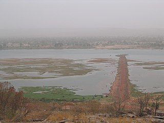
Koulikoro Cercle is an administrative subdivision of the Koulikoro Region of Mali. Its seat is the town of Koulikoro, which is also the capital of the region. A major trade and industrial town on the Niger River, Koulikoro has been surpassed by Kati to the west as the largest town in the region. Also to the southwest, lying entirely within Kati Cercle but administratively separate, is the District of Bamako, which after independence was carved out of the middle of the region.
Kolokani Cercle is an administrative subdivision of the Koulikoro Region of Mali. Its seat is the town of Kolokani, which is also its largest settlement. It lies directly to the north of Kati Cercle. Also to the south, is the District of Bamako, which after independence was carved out of the middle of the Region. The cercle is further divided into communes.

Dioïla Cercle is an administrative subdivision of the Koulikoro Region of Mali. Its seat is the town of Dioïla. It lies at the southeast corner of the region, and prior to 1977, it was combined with what is now Kati Cercle and the District of Bamako in the "Bamako Cercle", with the capital city as its seat.

Banamba Cercle is an administrative subdivision of the Koulikoro Region of Mali. Its seat is the town of Banamba, which is also its largest settlement. It lies at the center east of the region.

The Kangaba Cercle is an administrative subdivision of the Koulikoro Region of Mali. Its seat is the town and commune of Benkadi Habaladougou (Kenieba), also known as Kangaba. It lies at the southwest corner of the region, along the Guinean border, with the Niger River forming its southern edge.
Bancoumana or Bankoumana is a small town and rural commune in the Cercle of Kati in the Koulikoro Region of south-western Mali. The commune includes the town and 13 villages. At the time of the 2009 census it had a population of 21,714. The town of Bancoumana lies on the left bank of the River Niger 60 km southwest of Bamako, the Malian capital.
Dialakorodji is a town and small commune in the Cercle of Kati in the Koulikoro Region of south-western Mali. Although classified as a rural commune, Dialakorodji is now a northern suburb of Bamako, the Malian capital. The population has been increasing very rapidly. In the 2008 census the population was 12,938 but this had increased to 47,740 by 2009, an annual growth of 12%.
Dogodouman is a small town and commune in the Cercle of Kati in the Koulikoro Region of south-western Mali. The small commune is classified as rural commune but lies close to the western suburbs of Bamako, the Malian capital, at the edge of the Monts Mandigues. In the 2009 census the commune had a population of 8,851.
N'Gouraba is a village and rural commune in the Cercle of Kati in the Koulikoro Region of south-western Mali. The commune covers an area of 579 square kilometers and includes 13 villages. In the 2009 census the commune had a population of 15,474. The village of N'Gouraba is 75 km southeast of the Malian capital, Bamako.
N'Gabacoro or N'Gabacoro-Droit is a small town and rural commune in the Cercle of Kati in the Koulikoro Region of south-western Mali. The commune covers an area of 103 square kilometers and includes the town and 6 villages. In the 2009 census the commune had a population of 15,153. The town of N'Gabacoro lies 18 km east of the Malian capital, Bamako.
Mandé is a commune in the Cercle of Kati in the Koulikoro Region of south-western Mali. The commune lies to the southwest of Bamako, the Malian capital, along the left bank of the Niger River. It covers for an area of 730 km2 and includes the small town of Ouezzindougou, the administrative centre, and 24 villages. In the 2009 census the commune had a population of 59,352.
Neguela is a small town and seat of the commune of Bossofala in the Cercle of Kati in the Koulikoro Region of south-western Mali. The lies 61 km northwest of Bamako, the Malian capital.
Torodo is a village and seat of the commune of Diédougou in the Cercle of Kati in the Koulikoro Region of south-western Mali. The village is 60 km northwest of Bamako, the Malian capital.
Ouezzindougou is a small town and seat of the commune of Mandé in the Cercle of Kati in the Koulikoro Region of south-western Mali. The town lies 17 km southwest of Bamako, the Malian capital, and to the north of the Niger River.
Faladié is a village and seat of the commune of N'Tjiba in the Cercle of Kati in the Koulikoro Region of south-western Mali. The village lies 77 km northwest of the Malian capital, Bamako.
Sanankoroba is a small town and rural commune in the Cercle of Kati in the Koulikoro Region of southern Mali. The commune covers an area of approximately 617 square kilometers and includes the town and 25 villages. In the 2009 census the commune had a population of 37,294. The town lies 34 km south of the Malian capital, Bamako, on the Route Nationale 7 (RN7).


