
The Sentinel Range is a major mountain range situated northward of Minnesota Glacier and forming the northern half of the Ellsworth Mountains in Antarctica. The range trends NNW-SSE for about 185 km (115 mi) and is 24 to 48 km wide. Many peaks rise over 4,000 m (13,100 ft) and Vinson Massif (4892 m) in the southern part of the range is the highest elevation on the continent.
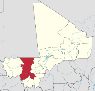
Koulikoro Region is a region in western Mali. It is the second administrative area of Mali and covers an area of 90,120 km2. Its capital is the city of Koulikoro.
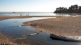
Van Damme State Park is a public beach consisting of about 1,831 acres (7.41 km2) of land in Mendocino County, California, near the town of Little River on State Route 1. It was named for Charles F. Van Damme (1881–1934), who was born in the area and purchased the land that is now the park with profits from a San Francisco ferry business. On his death, the property became part of the California state park system.

Valparaíso is a city in the north central Mexican state of Zacatecas.
Brackendale Eagles Provincial Park is a provincial park in British Columbia, Canada, located on the Squamish River adjacent to Brackendale, a suburban neighbourhood of Squamish. It is notable for its bald eagle population during the winter months and is inaccessible to visitors.
Malaspina Provincial Park is a provincial park in British Columbia, Canada, located on the northeast side of the Malaspina Peninsula facing Desolation Sound in the northernmost area of that province's Sunshine Coast region.
Sunnybrae Provincial Park is a provincial park in British Columbia, Canada, located on the northern side of the Salmon Arm of Shuswap Lake, near the city of Salmon Arm. Sunnybrae is a day use park with washrooms, picnic tables, playground and swimming area.

Providence is a community in the Demerara-Mahaica Region of Guyana, on the east bank of the Demerara River, located at 6°46′0″N58°10′0″W, altitude 1 metre. Providence is approximately 10 kilometres (6.2 mi) south of the capital, Georgetown.

The French submarine Rubis was a Saphir-class minelaying submarine which first served in the French submarine force, then the Free French Naval Forces (FNFL) during the Second World War and back with the French Navy. The boat was awarded numerous awards. Accordingly, as a result of Rubis's service with the FNFL, the boat was made a companion of the Ordre de la Libération by a decree issued by General Charles de Gaulle on 14 October 1941.
Villafranca de los Barros is a municipality in the province of Badajoz, Extremadura, Spain. It has a population of 13,329 and an area of 104 km2.

Bérégadougou is a department or commune of Comoé Province in southern Burkina Faso. Its capital lies at the town of Bérégadougou. According to the 2019 census the department has a total population of 15,164.
The Nazko First Nation is a First Nations government of the Dakelh people in the north-central Interior of British Columbia. Its reserves are located around the community of Nazko, British Columbia, which is 120 km west of Quesnel and southwest of Prince George.
Sibirila is a commune in the Cercle of Bougouni in the Sikasso Region of southern Mali. The principal town lies at Manankoro. In 1998 the commune had a population of 14,012.
Sansum Narrows is a strait or channel between Vancouver Island (W) and Saltspring Island (E) in the Southern Gulf Islands region of British Columbia, Canada. The narrows are between Maple Bay and Tl’ulpalus.
Yale First Nation is a First Nations government located at Yale, British Columbia. Yale has 16 distinct reserves stretching from near Sawmill Creek to American Creek, with the most southern reserve situated at Ruby Creek in the District of Kent.
The Taku River Tlingit First Nation are the band government of the Inland Tlingit in far northern British Columbia, Canada and also in Yukon. They comprise two ḵwaan (tribes) of the Tlingit people, who are otherwise coastal, the Áa Tlein Ḵwáan of the Atlin Lake area and the Deisleen Ḵwáan of Teslin Lake, whose main focus is the Teslin Tlingit Council in Teslin, Yukon. Their band offices are in Atlin, British Columbia, but follow Yukon Time year-round.
The Tlowitsis Nation, formerly the Klowitsis Tribe, the Turnour Island Band and the Tlowitsis-Mumtagila First Nation, is the Indian Act band government of the Ławit'sis (Tlowitsis) tribe of the Kwakwaka'wakw peoples, located in the Queen Charlotte Strait-Johnstone Strait area in the Discovery Islands between Vancouver Island and the British Columbia mainland in Canada. Ławit'sis territory covers parts of northern Vancouver Island, Johnstone Strait, and adjoining inlets of the mainland. Kalugwis, on Turnour Island, was their principal community in times past, but the band's offices are in the city of Campbell River to the southeast. Hanatsa IR No. 6 on Port Neville is the most populated of the band's Indian reserves.
Zehner is an unincorporated community in the rural municipality of Edenwold No. 158, Saskatchewan in Saskatchewan. This community is approximately 19 km northeast of Regina. It is also the administrative headquarters of the Piapot First Nation band government. Actor John Vernon was born in Zehner.

A breast-shaped hill is a hill in the shape of a breast. Some such hills are named "Pap", an archaic word for the breast or nipple of a woman. Such anthropomorphic geographic features are found in different places of the world and in some cultures they were revered as the attributes of the Mother Goddess, such as the Paps of Anu, named after Anu, an important female deity of pre-Christian Ireland.


