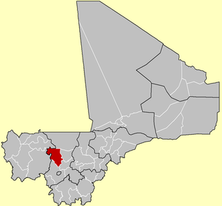
Koulikoro Region is a region in western Mali. It is the second administrative area of Mali and covers an area of 90,120 km2. Its capital is the city of Koulikoro.

Nara Cercle is an administrative subdivision of the Koulikoro Region of Mali. Its seat is the town of Nara.
Kolokani Cercle is an administrative subdivision of the Koulikoro Region of Mali. Its seat is the town of Kolokani, which is also its largest settlement. It lies directly to the north of Kati Cercle. Also to the south, is the District of Bamako, which after independence was carved out of the middle of the Region. The cercle is further divided into communes.

Dioïla Cercle is an administrative subdivision of the Koulikoro Region of Mali. Its seat is the town of Dioïla. It lies at the southeast corner of the region, and prior to 1977, it was combined with what is now Kati Cercle and the District of Bamako in the "Bamako Cercle", with the capital city as its seat.

Banamba Cercle is an administrative subdivision of the Koulikoro Region of Mali. Its seat is the town of Banamba, which is also its largest settlement. It lies at the center east of the region.

The Kangaba Cercle is an administrative subdivision of the Koulikoro Region of Mali. Its seat is the town and commune of Benkadi Habaladougou (Kenieba), also known as Kangaba. It lies at the southwest corner of the region, along the Guinean border, with the Niger River forming its southern edge.

Baguinéda-Camp is a small town and rural commune in the Cercle of Kati in the Koulikoro Region of southern Mali. The commune contains 32 villages and in the 2009 census had a population of 58,661. The town lies to the south of the Niger River.
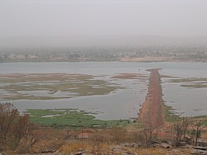
Bancoumana or Bankoumana is a small town and rural commune in the Cercle of Kati in the Koulikoro Region of south-western Mali. The commune includes the town and 13 villages. At the time of the 2009 census it had a population of 21,714. The town of Bancoumana lies on the left bank of the River Niger 60 km southwest of Bamako, the Malian capital.
Dio-Gare is a village and rural commune in the Cercle of Kati in the Koulikoro Region of south-western Mali. The commune has an area of 180 km2 and contains 7 villages. At the time of the 2009 census the commune had a population of 8,161. The main village, Dio-Gare, is 20 km northwest of Kati, the chef-lieu of the cercle. The Dakar–Niger Railway passes through the village.
Kalifabougou is a small town and rural commune in the Cercle of Kati in the Koulikoro Region of south-western Mali. The commune includes 12 villages and covers an area of 241 km2. In the 2009 census the population of the commune was 4,796. The village of Kalifabougou is 30 km northwest of Kati, the chef-lieu of the cercle.
Kambila is a village and rural commune in the Cercle of Kati in the Koulikoro Region of south-western Mali. The commune has an area of 429 km2 and contains 15 villages. In the 2009 census the commune had a population of 13,974. The village of Kambila lies just to the east of the Route Nationale 1 (RN1) and 9 km north of Kati, the chef-lieu of the cercle.
N'Tjiba is a rural commune in the Cercle of Kati in the Koulikoro Region of south-western Mali. The commune covers an area of approximately 802 square kilometers and includes 18 villages. The administrative centre is the village of Faladié. In the 2009 census the commune had a population of 23,617.

Ouélessébougou is a town and rural commune in the Cercle of Kati in the Koulikoro Region of south-western Mali. The commune covers an area of approximately 1,118 square kilometers and includes the town of Ouélessébougou and 44 villages. In the 2009 census the commune had a population of 50,056. The town lies 80 km south of Bamako on the Route Nationale 7.
Diago is a village and rural commune in the Cercle of Kati in the Koulikoro Region of south-western Mali. The commune contains 7 villages and in the 2009 census had a population of 3,269. The village of Diago is 10 km northwest the town of Kati, the chef-lieu of the cercle.
Nioumamakana or Niouma Makana is a village and rural commune in the Cercle of Kati in the Koulikoro Region of south-western Mali. The commune covers an area of 311 square kilometers and includes 10 villages. In the 2009 census it had a population of 7,442. The administrative centre (chef-lieu) is the village of Nioumamakana.
Niagadina is a village and rural commune in the Cercle of Kati in the Koulikoro Region of south-western Mali. The commune has an area of 87 square kilometers and includes five villages. The administrative center is the village of Niagadina which lies on the right bank of the Niger River, 72 km southwest of Bamako, the Malian capital. In the 2009 census the commune had a population of 11,961.
Yélékébougou is a village and rural commune in the Cercle of Kati in the Koulikoro Region of south-western Mali. The commune has an area of approximately 288 square kilometers and includes 16 villages. In the 2009 census the commune had a population of 7,257. The village of Yélékébougou is 30 km north of the town of Kati, the chef-lieu of the cercle.
Mandé is a commune in the Cercle of Kati in the Koulikoro Region of south-western Mali. The commune lies to the southwest of Bamako, the Malian capital, along the left bank of the Niger River. It covers for an area of 730 km2 and includes the small town of Ouezzindougou, the administrative centre, and 24 villages. In the 2009 census the commune had a population of 59,352.
Sobra is a rural commune in the Kati Cercle of the Koulikoro Region of Mali. The commune covers an area of approximately 938 square kilometers and contains 10 villages. In the 2009 census it had a population of 9,900. The administrative centre (chef-lieu) is the village of Sandama.
Sanankoroba is a small town and rural commune in the Cercle of Kati in the Koulikoro Region of southern Mali. The commune covers an area of approximately 617 square kilometers and includes the town and 25 villages. In the 2009 census the commune had a population of 37,294. The town lies 34 km south of the Malian capital, Bamako, on the Route Nationale 7 (RN7).