Bourem Cercle

Last updated
Bourem
Cercle of Bourem.png
Cercle of Bourem in Mali
CountryFlag of Mali.svg  Mali
Region Gao Region
Admin HQ ( Chef-lieu ) Bourem
Area
[1]
  Total43,000 km2 (17,000 sq mi)
Population
 (2009) [2]
  Total115,958
  Density2.7/km2 (7.0/sq mi)
Time zone UTC+0 (GMT)

Bourem Cercle is an administrative subdivision of the Gao Region of north-eastern Mali. The administrative center ( chef-lieu ) is the town of Bourem.

Gao Region Region in Mali

The Gao Region is in northeastern Mali. The capital city is Gao.

Mali Republic in West Africa

Mali, officially the Republic of Mali, is a landlocked country in West Africa, a region geologically identified with the West African Craton. Mali is the eighth-largest country in Africa, with an area of just over 1,240,000 square kilometres (480,000 sq mi). The population of Mali is 18 million. 67% of its population was estimated to be under the age of 25 in 2017. Its capital is Bamako. The sovereign state of Mali consists of eight regions and its borders on the north reach deep into the middle of the Sahara Desert, while the country's southern part, where the majority of inhabitants live, features the Niger and Senegal rivers. The country's economy centers on agriculture and mining. Some of Mali's prominent natural resources include gold, being the third largest producer of gold in the African continent, and salt.

Bourem Commune and town in Gao Region, Mali

Bourem is a commune and small town in the Gao Region of northeastern Mali. The town sits on the left bank of the River Niger.

The cercle is divided into five communes: [3]

Related Research Articles

Kita Cercle Cercle in Kayes Region, Mali

Kita Cercle is an administrative subdivision of the Kayes Region of Mali. The administrative centre (chef-lieu) is the town of Kita. In the 2009 census the population of the cercle was 434,379.

Kéniéba Cercle Cercle in Kayes Region, Mali

Kéniéba Cercle is a subdivision of the Kayes Region of Mali. The administrative center (chef-lieu) is the town of Kéniéba.

Nioro Cercle Cercle in Kayes Region, Mali

Nioro Cercle is an administrative subdivision of the Kayes Region of Mali. Its administrative center (chef-lieu) is the town of Nioro du Sahel. The commune is on the Mauritanian border and has long been a major stop on the trans-Saharan trade.

Dioïla Cercle Cercle in Koulikoro Region, Mali

Dioïla Cercle is an administrative subdivision of the Koulikoro Region of Mali. Its seat is the town of Dioïla. It lies at the southeast corner of the region, and prior to 1977, it was combined with what is now Kati Cercle and the District of Bamako in the "Bamako Cercle", with the capital city as its seat.

Bougouni Cercle Cercle in Sikasso Region, Mali

Bougouni Cercle is an administrative subdivision of the Sikasso Region of Mali. The administrative center (chef-lieu) is the town of Bougouni.

Kadiolo Cercle Cercle in Sikasso Region, Mali

Kadiolo Cercle is an administrative subdivision of the Sikasso Region of southern Mali. The administrative center (chef-lieu) is the town of Kadiolo.

Sikasso Cercle Cercle in Sikasso Region, Mali

Sikasso Cercle is one of seven administrative subdivision of the Sikasso Region of southern Mali. The capital is the town of Sikasso.

Yanfolila Cercle Cercle in Sikasso Region, Mali

Yanfolila Cercle is an administrative subdivision of the Sikasso Region of southern Mali. The administrative center (chef-lieu) is the town of Yanfolila.

Yorosso Cercle Cercle in Sikasso Region, Mali

Yorosso Cercle is an administrative subdivision of the Sikasso Region of southern Mali. The main town (chef-lieu) is Yorosso.

Bla Cercle Cercle in Ségou Region, Mali

Bla Cercle is an administrative subdivision of the Ségou Region of Mali. The administrative center (chef-lieu) is the town of Bla.

Macina Cercle Cercle in Ségou Region, Mali

Macina Cercle is an administrative subdivision of the Ségou Region of Mali. The administrative center (chef-lieu) is the town of Macina.

Ségou Cercle Cercle in Ségou Region, Mali

Ségou Cercle is an administrative subdivision of the Ségou Region of Mali. The administrative center (chef-lieu) is the town of Ségou.

San Cercle Cercle in Ségou Region, Mali

San Cercle is an administrative subdivision of the Ségou Region of Mali. The administrative center (chef-lieu) is the town of San.

Tominian Cercle Cercle in Ségou Region, Mali

Tominian Cercle is an administrative subdivision of the Ségou Region of Mali. The administrative center of the local government is in the town of Tominian. The Cercle is divided into Communes, and below this, quarters/villages. In the 2009 census the cercle had a population of 219,853 people.

Koro Cercle Cercle in Mopti Region, Mali

Koro Cercle is an administrative subdivision of the Mopti Region of Mali. The administrative center is the town of Koro.

Youwarou Cercle Cercle in Mopti Region, Mali

Youwarou Cercle is an administrative subdivision of the Mopti Region of Mali. The administrative center (chef-lieu) is the town of Youwarou.

Diré Cercle Cercle in Tombouctou Region, Mali

Diré Cercle is an administrative subdivision of the Tombouctou Region of Mali. The administrative center (chef-lieu) is the town of Diré.

Timbuktu Cercle Cercle in Tombouctou Region, Mali

Timbuktu Cercle is an administrative subdivision of the Tombouctou Region of Mali. It is the largest cercle by area in the whole of Mali. The capital lies at the city of Timbuktu. The cercle is divided into Rural and Urban Communes, and below this, quarters/villages. In the 2009 census the cercle had a population of 124,546.

Ansongo Cercle Cercle in Gao Region, Mali

Ansongo Cercle is an administrative subdivision of the Gao Region of Mali. The administrative center (chef-lieu) is the town of Ansongo. The Niger River passes through the cercle and plays an important role in transportation and the economy in the region.

Gabero Commune in Gao Region, Mali

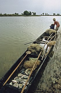
Gabero is a rural commune in the Cercle of Gao in the Gao Region of south-eastern Mali. The commune covers an area of approximately 2,007 square kilometers and includes 15 villages. In the 2009 census the commune had a population of 25,688. The Niger River crosses the commune from north to south. The administrative center (chef-lieu) is Haoussa Foulane that lies on the left (east) bank of the Niger. The village is 45 km south of Gao, on the road, the N17, linking Gao and Ansongo.

References

  1. Synthèse des Plans de Securité Alimentaire des Communes du Cercle de Bourem 2005-2009 (PDF) (in French), Commissariat à la Sécurité Alimentaire, République du Mali, USAID-Mali, 2005, archived from the original (PDF) on 2011-07-20, retrieved 2011-02-10.
  2. Resultats Provisoires RGPH 2009 (Région de Gao) (PDF) (in French), République de Mali: Institut National de la Statistique, archived from the original (PDF) on 2011-07-22.
  3. Loi N°99-035/ du 10 Aout 1999 Portant Création des Collectivités Territoriales de Cercles et de Régions (PDF) (in French), Ministère de l'Administration Territoriales et des Collectivités Locales, République du Mali, 1999, archived from the original (PDF) on 2012-03-09.

Coordinates: 16°56′46″N0°18′47″W / 16.946°N 0.313°W / 16.946; -0.313

Geographic coordinate system Coordinate system

A geographic coordinate system is a coordinate system that enables every location on Earth to be specified by a set of numbers, letters or symbols. The coordinates are often chosen such that one of the numbers represents a vertical position and two or three of the numbers represent a horizontal position; alternatively, a geographic position may be expressed in a combined three-dimensional Cartesian vector. A common choice of coordinates is latitude, longitude and elevation. To specify a location on a plane requires a map projection.