Bamba is a small town and rural commune in the Bourem Cercle of the Gao Region of Mali. The town is located on the left (north) bank of the Niger River, 190 km east of Timbuktu and 230 km northwest of the town of Gao. In the 2009 census the commune had a population of 28,524.

Bourem is a commune and small town in the Gao Region of northeastern Mali. The town sits on the left bank of the River Niger.
Djidian is a village and rural commune in the Cercle of Kita in the Kayes Region of south-western Mali. The commune includes 14 villages and in the 2009 census had a population of 18,702.
Kita Ouest is a rural commune in the Cercle of Kita in the Kayes Region of south-western Mali. The commune contains 16 villages and in the 2009 census had a population of 14,966. The main village (chef-lieu) is Kofeba.
Bourem Cercle is an administrative subdivision of the Gao Region of north-eastern Mali. The administrative center (chef-lieu) is the town of Bourem.

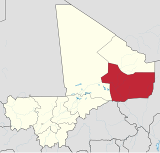
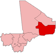
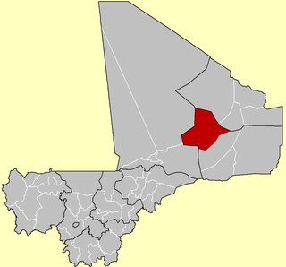
Gao Cercle is an administrative subdivision of the Gao Region of north-eastern Mali. The administrative center (chef-lieu) is the town of Gao.
Banko is a rural commune and village in the Cercle of Dioïla in the Koulikoro Region of south-western Mali. The village lies on the Banifing River. The commune contains 31 villages.
Bara is a rural commune and village in the Cercle of Ansongo in the Gao Region of south-eastern Mali.
Talataye is a village and rural commune in the Cercle of Ansongo in the Gao Region of south-eastern Mali. The commune has an area of approximately 8,126 square kilometers. In the 2009 census it had a population of 13,907.
Taboye is a rural commune and village in the Cercle of Bourem in the Gao Region of south-eastern Mali. The commune is crossed by the River Niger and includes the villages of Bia, Dagha, Ha, Moudakane, Ouani, Tondibi and Taboye. In the 2009 census the commune had a population of 20,503.
Inékar is a village and cercle of Ménaka Region in southeastern Mali. It has an area of approximately 27,000 square kilometers and in 2009 had a population of 8,714. It was previously a commune in Ménaka Cercle but was promoted to the status of a cercle when Ménaka Region was implemented in 2016.
Gabero is a rural commune in the Cercle of Gao in the Gao Region of south-eastern Mali. The commune covers an area of approximately 2,007 square kilometers and includes 15 villages. In the 2009 census the commune had a population of 25,688. The Niger River crosses the commune from north to south. The administrative center (chef-lieu) is Haoussa Foulane that lies on the left (east) bank of the Niger. The village is 45 km south of Gao, on the road, the N17, linking Gao and Ansongo.
Gounzoureye is a rural commune in the Cercle of Gao in the Gao Region of south-eastern Mali. The commune includes the villages of Koima, Tchirissoro, Sadou, Lobou, Sidibé, Kosseye, Gorom Gorom, Kadji, Wabaria, Arhabou, Tacharane, Bagoundjé I and Bagoundjé II, which are all located on the banks of the River Niger. The administrative center (chef-lieu) is at the village of Wabaria. In the 2009 census the commune had a population of 30,772.
N'Tillit is a rural commune and village in the Cercle of Gao in the Gao Region of south-eastern Mali. In the 2009 census the commune had a population of 22,100.
Sony Aliber or Soni Ali Ber is a commune in the Cercle of Gao in the Gao Region of south-eastern Mali. The main villages are: Bagnadji, Batal, Berrah, Forgho Arma, Forgho Songhai, Kochakarey, Kokorom, Magnadoué, Seina and Zindiga. The administrative center (Chef-lieu) is the village of Forgo Sourhai which is located 25 km north of Gao. The commune includes the banks of the River Niger for a distance of around 35 km. In the 2009 census the commune had a population of 44,099.
Boussin is a village and rural commune in the Cercle of Ségou in the Ségou Region of southern-central Mali. The commune includes 15 villages in an area of approximately 178 square kilometers. In the 2009 census it had a population of 12,401. The village of Boussin lies 36 km east of Ségou.
Dallah is a village and rural commune in the Cercle of Douentza in the Mopti Region of Mali. The village is located close to the southern edge of the Gandamia Massif, an inselberg that rises 750 m above the plain. The massif extends for 60 km in an east-west direction and 10 km north to south. The metalled road, the RN16, that run between Mopti and Gao passes to the south of the village. The commune contains 12 villages and in the 2009 census had a population of 8,504.
Bamba is a rural commune of the Cercle of Koro in the Mopti Region of Mali. The commune contains 14 villages and in the 2009 census had a population of 13,610. Most of the population of the commune are Dogon. The administrative centre (chef-lieu) is the village of Déguéré.
Lambidou is a rural commune and village in the Cercle of Diéma in the Kayes Region of western Mali. As well as the main village (chef-lieu) of Lambidou, the commune includes the villages of Singoné, Koumarenga and Kary. In the 2009 census the commune had a population of 14,947.