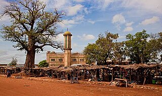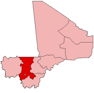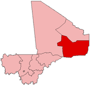
Kidal is a town and commune in the desert region of northern Mali. The town lies 285 km (177 mi) northeast of Gao and is the capital of the Kidal Cercle and the Kidal Region. The commune has an area of about 9,910 km2 (3,830 sq mi) and includes the town of Kidal and 31 other settlements.

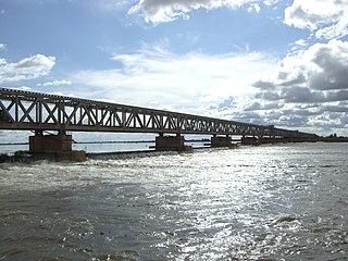
Markala is a commune in Mali's Ségou Region on the Niger River 35 km down stream from the town of Ségou. The commune contains 30 villages in an area of 318 square kilometers and in 2009 had a population of 45,961. Mali's primary irrigation dam, the Markala dam, lies in the commune. The main village of the commune, Diamarabougou, is on the right bank adjacent to the dam which also serves as an important road bridge.

Tessalit is a rural commune and village in the Kidal Region of Mali. The village is the administrative centre of Tessalit Cercle (district). The village lies 85 kilometres (53 mi) north of Adjelhoc and about 70 kilometres (43 mi) from the Algerian border. The commune extends over an area of 30,000 square kilometres (12,000 sq mi) that is almost entirely desert. In the 2009 census the commune had a population of 5,739.
Sokolo is a small town and rural commune in the Cercle of Niona in the Ségou Region of southern-central Mali. The commune has an area of approximately 2,219 square kilometers and includes the town and 17 villages. In the 2009 census the population was 23,338. The town lies 56 km north of Niono.

Nara is a town and rural commune in the Koulikoro Region of southwestern Mali. The town is the administrative center of the Nara Cercle. It is about 37 kilometres (23 mi), south of the international border with Mauritania and approximately 374 kilometres (232 mi), by road, northeast of the Malian capital, Bamako.
Ansongo is a rural commune and small town in the Gao Region of eastern Mali. The town lies on the left bank of the Niger River 90 km south of Gao. It is the administrative center for the surrounding Ansongo Cercle. The commune covers an area of 445 square kilometers and in the 2009 census had a population of 32,709.

Ansongo Cercle is an administrative subdivision of the Gao Region of Mali. The administrative center (chef-lieu) is the town of Ansongo. The Niger River passes through the cercle and plays an important role in transportation and the economy in the region.

Bancoumana or Bankoumana is a small town and rural commune in the Cercle of Kati in the Koulikoro Region of southwestern Mali. The commune includes the town and 13 villages. At the time of the 2009 census it had a population of 21,714. The town lies on the left bank of the River Niger 60 km southwest of Bamako, the Malian capital.
N'Gabacoro or N'Gabacoro-Droit is a small town and rural commune in the Cercle of Kati in the Koulikoro Region of south-western Mali. The commune covers an area of 103 square kilometers and includes the town and 6 villages. In the 2009 census the commune had a population of 15,153. The town of N'Gabacoro lies 18 km east of the Malian capital, Bamako.

Mandé is a commune in the Cercle of Kati in the Koulikoro Region of south-western Mali The commune lies to the southwest of Bamako, the Malian capital, along the left bank of the Niger River. It covers for an area of 730 km2 and includes the small town of Ouezzindougou, the administrative centre, and 24 villages. In the 2009 census the commune had a population of 59,352.
Dougabougou is a small town and rural commune in the Cercle of Ségou in the Ségou Region of southern-central Mali. The commune covers an area of approximately 180 square kilometers and includes the town and 6 villages. In the 2009 census the population was 29,208. The town lies 20 km north of the Markala dam. Many of the inhabitants are employed in the production of sugar on land irrigated by the Office du Niger scheme. A Chinese-Malian company produces sugar in the town.
Diabaly is a small town and rural commune in the Cercle of Niono in the Ségou Region of Mali. The commune has an area of approximately 1,538 square kilometres (594 sq mi) and includes 28 villages as well as the town. In the 2009 census the commune had a population of 35,266. The town lies 50 kilometres (31 mi) north of Niono on the west side of the Fala de Molodo channel that forms part of the Office du Niger irrigation scheme. The fields around the town are irrigated but much of the commune lies to the east of the Fala de Molodo in an area that lacks irrigation.
Konna is a town and rural commune in the Cercle of Mopti in the Mopti Region of Mali. The town lies 60 km northeast of Mopti on the eastern edge of the flood plain of the Niger River. The main RN16 highway linking Sévaré and Gao branches to the east just to the south of the town. The commune has an area of approximately 838 km2 and contains the town and 24 of the surrounding villages. In the 2009 census, it had a population of 36,767.
Ténenkou is a village and commune and seat of the Ténenkou Cercle in the Mopti Region of Mali. In 2009 the commune had a population of 11,310.
Sanankoroba is a small town and rural commune in the Cercle of Kati in the Koulikoro Region of southern Mali. The commune covers an area of approximately 617 square kilometers and includes the town and 25 villages. In the 2009 census the commune had a population of 37,294. The town lies 34 km south of the Malian capital, Bamako, on the Route Nationale 7 (RN7).
In August 2022, an attack by suspected Islamists killed 42 Malian soldiers and injured 22 more. The attack was one of the deadliest attacks in recent years during the Mali War.
Events in the year 2022 in Mali.
Between March 15 and 16, 2021, Islamic State in the Greater Sahara fighters clashed with Malian and French troops over control of a Malian military base near the town of Tessit, with ISGS jihadists overrunning the coalition.
Between February 18 and 19, 2022, clashes broke out in Archam, Mali, near the border with Burkina Faso and Niger, between the Malian Army and unknown jihadists.

On October 16, 2014, clashes broke out between the pro-government GATIA miltiia and the National Movement for the Liberation of Azawad in N'Tillit, Mali.


