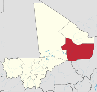
Bamba is a small town and rural commune in the Bourem Cercle of the Gao Region of Mali. The town is located on the left (north) bank of the Niger River, 190 km east of Timbuktu and 230 km northwest of the town of Gao. In the 2009 census the commune had a population of 28,524.

Bourem is a commune and small town in the Gao Region of northeastern Mali. The town sits on the left bank of the River Niger.
Essakane is a rural commune and village of the Cercle of Goundam in the Tombouctou Region of Mali. The commune includes around 16 small settlements. The small village of Essakane is around 70 kilometers west of the town of Timbuktu. The commune includes Lake Faguibine and two depression, Lake Kamango and Lake Gouber, which fill with water in years when the annual flood of the Niger River is particularly extensive.
Bara is a rural commune and village in the Cercle of Ansongo in the Gao Region of south-eastern Mali.
Taboye is a rural commune and village in the Cercle of Bourem in the Gao Region of south-eastern Mali. The commune is crossed by the River Niger and includes the villages of Bia, Dagha, Ha, Moudakane, Ouani, Tondibi and Taboye. In the 2009 census the commune had a population of 20,503.
Gabero is a rural commune in the Cercle of Gao in the Gao Region of south-eastern Mali. The commune covers an area of approximately 2,007 square kilometers and includes 15 villages. In the 2009 census the commune had a population of 25,688. The Niger River crosses the commune from north to south. The administrative center (chef-lieu) is Haoussa Foulane that lies on the left (east) bank of the Niger. The village is 45 km south of Gao, on the road, the N17, linking Gao and Ansongo.
Dangha is a village and commune of the Cercle of Diré in the Tombouctou Region of Mali.
Garbakoïra is a commune and village of the Cercle of Diré in the Tombouctou Region of Mali. The village lies on the left bank of the left arm of the River Niger, 35 km south west of the town of Timbuktu and 37 km north east of the town of Diré.
Haibongo is a village and rural commune of the Cercle of Diré in the Tombouctou Region of Mali.
Sareyamou is a village and commune of the Cercle of Diré in the Tombouctou Region of Mali. The commune contains 11 settlements.
Tienkour is a village and rural commune of the Cercle of Diré in the Tombouctou Region of Mali.
Doukouria is a village and rural commune of the Cercle of Goudam in the Tombouctou Region of Mali.
Koumaïra is a rural commune and village of the Cercle of Niafunké in the Tombouctou Region of Mali. The village is on the south bank of the Bara-Issa, a branch of the Niger River that flows when the river is in flood. It lies 21 km south east of the town of Niafunké and 65 km north east of Lake Debo. The commune contains around 36 small settlements.
Soumpi is a village and commune of the Cercle of Niafunké in the Tombouctou Region of Mali. Lac Soumpi is a lake of note here, as is the archaeological site of Tissalaten.
Banikane Narhawa is a village and commune of the Cercle of Niafunké in the Tombouctou Region of Mali.
Binga is a rural commune of the Cercle of Diré in the Tombouctou Region of Mali. The administrative center (chef-lieu) is the village of Sarakoira.
Tinguereguif is a rural commune of the Cercle of Diré in the Tombouctou Region of Mali. The administrative center (chef-lieu) is the village of Gari.
Issa Bery is a commune of the Cercle of Goundam in the Tombouctou Region of Mali. The administrative center (chef-lieu) is the village of Toucabangou which is on the south shore of Lake Faguibine. The commune includes areas of land both to the south and to the north of the lake.
Séréré is a rural commune of the Cercle of Gourma-Rharous in the Tombouctou Region of Mali. The administrative center (chef-lieu) is the village of Madiakoye.
Lafia is a commune of the Cercle of Timbuktu in the Tombouctou Region of Mali. The administrative center (chef-lieu) is the village of Aglal.