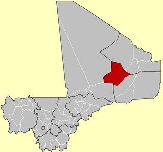
Ansongo Cercle is an administrative subdivision of the Gao Region of Mali. The administrative center (chef-lieu) is the town of Ansongo. The Niger River passes through the cercle and plays an important role in transportation and the economy in the region.
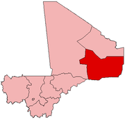
Bourem Cercle is an administrative subdivision of the Gao Region of north-eastern Mali. The administrative center (chef-lieu) is the town of Bourem.

Baguinéda-Camp is a small town and rural commune in the Cercle of Kati in the Koulikoro Region of southern Mali. The commune contains 32 villages and in the 2009 census had a population of 58,661. The town lies to the south of the Niger River.
Nyamina is a small town and rural commune in the Cercle of Koulikoro in the Koulikoro Region of south-western Mali. The commune lies to the north of the Niger River and covers an area of 1,283 km2. It includes the town of Nyamina and 47 villages. In the 2009 census the commune had a population of 35,548. The town lies on the left bank of the river, 80 km northeast of Koulikoro.
Bancoumana or Bankoumana is a small town and rural commune in the Cercle of Kati in the Koulikoro Region of south-western Mali. The commune includes the town and 13 villages. At the time of the 2009 census it had a population of 21,714. The town of Bancoumana lies on the left bank of the River Niger 60 km southwest of Bamako, the Malian capital.
Dio-Gare is a village and rural commune in the Cercle of Kati in the Koulikoro Region of south-western Mali. The commune has an area of 180 km2 and contains 7 villages. At the time of the 2009 census the commune had a population of 8,161. The main village, Dio-Gare, is 20 km northwest of Kati, the chef-lieu of the cercle. The Dakar–Niger Railway passes through the village.
Faraba is a village and rural commune in the Cercle of Kati in the Koulikoro Region of south-western Mali. The commune contains 6 villages and in the 2009 census had a population of 9,577.
Tiakadougou-Dialakoro is a village and rural commune in the Cercle of Kati in the Koulikoro Region of south-western Mali. The commune covers an area of 327 square kilometers and includes 9 villages. In the 2009 census it had a population of 6,738.
Kourouba is a village and rural commune in the Cercle of Kati in the Koulikoro Region of south-western Mali. The commune covers an area of 245 km2 and includes 5 villages. In the 2009 census the commune had a population of 8,248. The village of Kourouba is on the right bank of the Sankarani River just upstream of where it joins the Niger River.
Niagadina is a village and rural commune in the Cercle of Kati in the Koulikoro Region of south-western Mali. The commune has an area of 87 square kilometers and includes five villages. The administrative center is the village of Niagadina which lies on the right bank of the Niger River, 72 km southwest of Bamako, the Malian capital. In the 2009 census the commune had a population of 11,961.
Dioro is a town and rural commune in the Cercle of Ségou in the Ségou Region of southern-central Mali. The commune extends over an area of approximately 586 square kilometers on the right bank of the Niger River and includes the town and 29 of the surrounding villages. In the 2009 census the commune had a population of 47,876. The town of Dioro is located 57 km northeast of Ségou on the bank of the river.
Sébougou is a village and rural commune in the Cercle of Ségou in the Ségou Region of southern-central Mali. The commune contains 10 villages in an area of approximately 115 square kilometers. In the 2009 census it had a population of 16,175. The commune lies to the south of the River Niger and to the west of the urban commune of Ségou.
Konodimini is a village and rural commune in the Cercle of Ségou in the Ségou Region of southern-central Mali. The commune includes 23 villages in an area of approximately 362 square kilometers. In the 2009 census it had a population of 16719. The village of Konodimini, the chef-lieu of the commune, lies 23 km southwest of Ségou, on the right (south) bank of the Niger River.
Sama Foulala is a village and rural commune in the Cercle of Ségou in the Ségou Region of southern-central Mali. The commune contains 7 villages in an area of approximately 154 square kilometers. In the 2009 census it had a population of 6,180. The village of Sama Foulala, is on the left (north) bank of the River Niger.
Farako is a small town and rural commune in the Cercle of Ségou in the Ségou Region of southern-central Mali. The commune lies on the north bank of the Niger River and contains 11 settlements in an area of 200 square kilometers. In the 2009 census it had a population of 17,570. The town of Farako is the chef-lieu of the commune.
Kolongo or Kolongo Tomo is a village and rural commune in the Cercle of Macina in the Ségou Region of southern-central Mali. The commune covers an area of approximately 484 square kilometers and includes 37 villages. In the 2009 census the commune had a population of 37,648. The village lies on the Fala de Boky-Wéré, an ancient branch of the Niger River that now forms part of the irrigation system of the Office du Niger.

Kokry is a village and rural commune in the Cercle of Macina in the Ségou Region of southern-central Mali. The commune covers an area of approximately 160 square kilometers and includes 17 villages. The farmland is irrigated by the Office du Niger irrigation scheme. The main crop is rice. In the 2009 census the commune had a population of 13,393. The main village, (chef-lieu), is called Kokry Centre to distinguish it from Kokry Bozo which lies 3 km to the east on a strip of land between the Niger River and the Distributeur Kokry, an irrigation canal.
Dogofry is a village and a rural commune in the Cercle of Niona in the Ségou Region of southern-central Mali. The commune covers an area of approximately 3,820 square kilometers and is bordered to the north by the Republic of Mauritania, to the east by the commune of Nampalari, to the southeast by the commune of Diabaly, to the southwest by the commune of Sokolo and to the west by the commune of Guiré in the Cercle of Nara. It includes 19 villages, and had a population of 34,057 in the 2009 census. The south of the commune includes a region irrigated as part of the Office du Niger scheme. The village of Dogofry lies in this irrigated area, about 60 km north of Niono, to the west of the Fala de Molodo and the Distributeur de Kogoni.
Diganibougou or Diganidougou is a rural commune in the Cercle of Ségou in the Ségou Region of Mali. The commune lies to the north of the Niger River opposite the urban commune of Ségou and includes 22 villages in an area of approximately 571 square kilometers. In the 2009 census the commune had a population of 13,879. The administrative center (chef-lieu) is the village of Digani.
Farakou Massa is a rural commune in the Cercle of Ségou in the Ségou Region of Mali. The commune lies along the right bank of the River Niger and includes 8 villages in an area of approximately 109 square kilometers. In the 2009 census it had a population of 14,314. The administrative center (chef-lieu) of the commune is the village of Kominé which is 49 km northeast of Ségou.