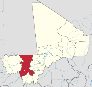
Koulikoro Region is a region in western Mali. It is the second administrative area of Mali and covers an area of 90,120 km2. Its capital is the city of Koulikoro.

Kati is an urban commune and the largest town in Mali's Koulikoro Region. The town is situated 15 km northwest of Bamako, Mali's capital, on the Dakar-Niger Railway. In the 2009 census, the commune had a population of 114,983.

Nara Cercle is an administrative subdivision of the Koulikoro Region of Mali. Its seat is the town of Nara.
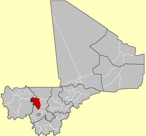
Koulikoro Cercle is an administrative subdivision of the Koulikoro Region of Mali. Its seat is the town of Koulikoro, which is also the capital of the region. A major trade and industrial town on the Niger River, Koulikoro has been surpassed by Kati to the west as the largest town in the region. Also to the southwest, lying entirely within Kati Cercle but administratively separate, is the District of Bamako, which after independence was carved out of the middle of the region.

Dioïla Cercle is an administrative subdivision of the Koulikoro Region of Mali. Its seat is the town of Dioïla. It lies at the southeast corner of the region, and prior to 1977, it was combined with what is now Kati Cercle and the District of Bamako in the "Bamako Cercle", with the capital city as its seat.

Banamba Cercle is an administrative subdivision of the Koulikoro Region of Mali. Its seat is the town of Banamba, which is also its largest settlement. It lies at the center east of the region.
Diouman or Dioumanzana is a village and commune in the Cercle of Dioila in the Koulikoro Region of southern Mali.
Bancoumana or Bankoumana is a small town and rural commune in the Cercle of Kati in the Koulikoro Region of south-western Mali. The commune includes the town and 13 villages. At the time of the 2009 census it had a population of 21,714. The town of Bancoumana lies on the left bank of the River Niger 60 km southwest of Bamako, the Malian capital.
Bougoula is a village and rural commune in the Cercle of Kati in the Koulikoro Region of south-western Mali. The commune contains 11 villages and at the time of the 2009 census had a population of 10,780. The village of Bougoula is 50 km south of the Malian capital, Bamako.
Daban is a village and rural commune in the Cercle of Kati in the Koulikoro Region of south-western Mali. The commune is the most northerly of the cercle. It contains 11 villages in an area of 737 square kilometers and at the time of 2009 census had a population of 9,435. The village of Daban is 80 km northwest of Kati, the chef-lieu of the cercle.
Dio-Gare is a village and rural commune in the Cercle of Kati in the Koulikoro Region of south-western Mali. The commune has an area of 180 km2 and contains 7 villages. At the time of the 2009 census the commune had a population of 8,161. The main village, Dio-Gare, is 20 km northwest of Kati, the chef-lieu of the cercle. The Dakar–Niger Railway passes through the village.
Faraba is a village and rural commune in the Cercle of Kati in the Koulikoro Region of south-western Mali. The commune contains 6 villages and in the 2009 census had a population of 9,577.
Kalifabougou is a small town and rural commune in the Cercle of Kati in the Koulikoro Region of south-western Mali. The commune includes 12 villages and covers an area of 241 km2. In the 2009 census the population of the commune was 4,796. The village of Kalifabougou is 30 km northwest of Kati, the chef-lieu of the cercle.
Kambila is a village and rural commune in the Cercle of Kati in the Koulikoro Region of south-western Mali. The commune has an area of 429 km2 and contains 15 villages. In the 2009 census the commune had a population of 13,974. The village of Kambila lies just to the east of the Route Nationale 1 (RN1) and 9 km north of Kati, the chef-lieu of the cercle.
N'Tjiba is a rural commune in the Cercle of Kati in the Koulikoro Region of south-western Mali. The commune covers an area of approximately 802 square kilometers and includes 18 villages. The administrative centre is the village of Faladié. In the 2009 census the commune had a population of 23,617.
Diago is a village and rural commune in the Cercle of Kati in the Koulikoro Region of south-western Mali. The commune contains 7 villages and in the 2009 census had a population of 3,269. The village of Diago is 10 km northwest the town of Kati, the chef-lieu of the cercle.
Doubabougou is a village and rural commune in the Cercle of Kati in the Koulikoro Region of south-western Mali. The commune contains 6 villages and had a population of 5,041 at the time of the 2009 census.
Yélékébougou is a village and rural commune in the Cercle of Kati in the Koulikoro Region of south-western Mali. The commune has an area of approximately 288 square kilometers and includes 16 villages. In the 2009 census the commune had a population of 7,257. The village of Yélékébougou is 30 km north of the town of Kati, the chef-lieu of the cercle.
Banko is a rural commune and village in the Cercle of Dioïla in the Koulikoro Region of south-western Mali. The village lies on the Banifing River. The commune contains 31 villages.
Diédougou is a rural commune in the Cercle of Kati in the Koulikoro Region of western Mali. The commune includes 16 villages. The main village (chef-lieu) is Torodo. In the 2009 census the commune had a population of 9,381.