Kidal | |
|---|---|
 | |
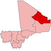
 Kidal Cercle in Mali | |
| Country | |
| Region | Kidal Region |
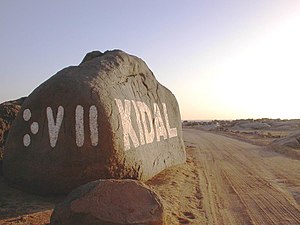
| Capital | Kidal |
| Area | |
| • Total | 21,353 km2 (8,244 sq mi) |
| Population (2009) [2] | |
| • Total | 33,087 |
| • Density | 1.5/km2 (4.0/sq mi) |
| Time zone | UTC+0 (GMT) |
Kidal Cercle is an administrative subdivision of the Kidal Region of Mali. The administrative center (chef-lieu) is the town of Kidal. The cercle is divided into rural and urban communes, and below this, quarters/villages. In 2009 the cercle had a population of 33,087. [2]

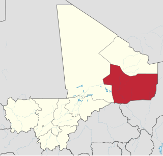
Kidal Region is the eighth administrative region of Mali, covering 151,450 square kilometres or 58,480 square miles. This area was formerly part of Gao Region, but was created as a separate region in 1991. It is located in the north of the country, within the territory which the National Movement for the Liberation of Azawad proclaimed to be the independent nation-state of Azawad on 6 April 2012. This independence has not been recognized by any country or international organization. It was under the control of different armed movements such as the Ansar Dine and MNLA until January 2013, when French forces liberated the region. The Region's administrative capital is the town of Kidal.

Mali, officially the Republic of Mali, is a landlocked country in West Africa. Mali is the eighth-largest country in Africa, with an area of just over 1,240,000 square kilometres (480,000 sq mi). The population of Mali is 18 million. 67% of its population was estimated to be under the age of 25 in 2017. Its capital is Bamako. The sovereign state of Mali consists of eight regions and its borders on the north reach deep into the middle of the Sahara Desert, while the country's southern part, where the majority of inhabitants live, features the Niger and Senegal rivers. The country's economy centers on agriculture and mining. Some of Mali's prominent natural resources include gold, being the third largest producer of gold in the African continent, and salt.
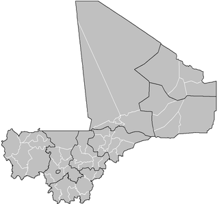
A cercle is the second level administrative unit in Mali. Mali is divided into eight régions and one capital district (Bamako); the régions are subdivided into 49 cercles. These subdivisions bear the name of their principal city.
The climate is typical Saharian with very little rainfall and large fluctuations in temperature. The average annual rainfall is around 130 mm but there are large year-to-year variations with 204 mm recorded in 1999 and only 66 mm in 1990. [1]
The mountain region of Adrar des Ifoghas was taken by French and Chadian forces on 22 February 2013 as part of the Northern Mali conflict. The area of In Arab, near Anefif, was captured by MNLA forces on 29-30 March 2013.

The Adrar des Ifoghas is a massif located in the Kidal Region of Mali, reaching into Algeria. It has an area of around 250,000 square kilometers.
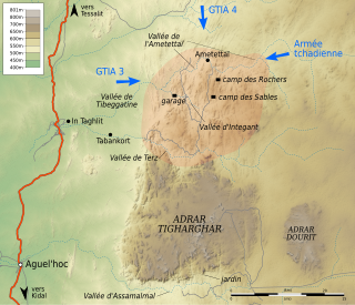
The Battle of Ifoghas, also known as the Battle of Tigharghâr or the Battle of the Ametettai, took place from 18 February to 31 March 2013, during the Northern Mali conflict. The French army and the Chadian army fought armed Salafist jihadist groups led by Al Qaeda in the Islamic Maghreb and Ansar Dine. After being defeated in January in the Battle of Konna and the Battle of Diabaly, the jihadists abandoned Timbuktu and retreated into the Adrar Tigharghar, a mountain of the Adrar of Ifoghas in northeastern Mali, which has been their sanctuary for years. The French started quickly a pursuit, and they took control of the towns of Tessalit and Aguelhok and begun the operation Panther in the Tigharghar. The first clashes erupt on February 18 and are mainly concentrated in the Ametettai Valley. It is caught between two armored columns, one French to the west and another Chadian to the east, while the paratroopers manage to surprise the jihadists by attacking on foot from the north. The valley is taken on March 3 and jihadists begin to gradually abandon the Tigharghar. Excavation missions and some skirmishes, however, continue to take place the following days. The operations cease on March 31. The battle was a turning point in the war, as with the capture of the Tigharghar, the jihadists lose their main sanctuary in the Sahel as well as most of their military arsenal, taken from the Malian army or Libya.

Anefif or Anéfis is a Saharan village and commune in the Cercle of Kidal in the Kidal Region of north-eastern Mali. The village lies 95 km (59 mi) southwest of Kidal on the route linking Kidal to Bourem and Gao. In 2009 the commune had a population of 5,087.