Tombouctou Region is one of the administrative regions of Mali. It is the largest of Mali's 10 regions and includes a large section of the Sahara Desert. For administrative purposes, the region is subdivided into five cercles.

Kidal is a town and commune in the desert region of northern Mali. The town lies 285 km (177 mi) northeast of Gao and is the capital of the Kidal Cercle and the Kidal Region. The commune has an area of about 9,910 km2 (3,830 sq mi) and includes the town of Kidal and 31 other settlements.
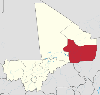
Kidal Region the eighth administrative region of Mali, covering 151,450 square kilometres or 58,480 square miles. This area was formerly part of Gao Region, but was created as a separate region in 1991. It is located in the north of the country, within the territory which the National Movement for the Liberation of Azawad proclaimed to be the independent nation-state of Azawad on 6 April 2012. This independence has not been recognized by any country or international organization. It was under the control of different armed movements such as the Ansar Dine and MNLA until January 2013, when French forces liberated the region. The Region's administrative capital is the town of Kidal.
The Gao Region is a region in northeastern Mali. The capital city is Gao.

Gargando is a small town located in the Tombouctou Region of Mali. The people are mainly from subdivisions of the Kel Ansar tribe. The village has many educated Touareg people.

Kita Cercle is an administrative subdivision of the Kayes Region of Mali. The administrative centre (chef-lieu) is the town of Kita. In the 2009 census the population of the cercle was 434,379.

Nioro Cercle is an administrative subdivision of the Kayes Region of Mali. Its administrative center (chef-lieu) is the town of Nioro du Sahel. The commune is on the Mauritanian border and has long been a major stop on the trans-Saharan trade.

Bougouni Cercle is an administrative subdivision of the Sikasso Region of Mali. The administrative center (chef-lieu) is the town of Bougouni.

Sikasso Cercle is one of seven administrative subdivision of the Sikasso Region of southern Mali. The capital is the town of Sikasso.

Yanfolila Cercle is an administrative subdivision of the Sikasso Region of southern Mali. The administrative center (chef-lieu) is the town of Yanfolila.

Yorosso Cercle is an administrative subdivision of the Sikasso Region of southern Mali. The main town (chef-lieu) is Yorosso.

Bla Cercle is an administrative subdivision of the Ségou Region of Mali. The administrative center (chef-lieu) is the town of Bla.

Douentza Cercle is an administrative subdivision of the Mopti Region of Mali. The administrative center (chef-lieu) is the town of Douentza.

Youwarou Cercle is an administrative subdivision of the Mopti Region of Mali. The administrative center (chef-lieu) is the town of Youwarou.
Diré Cercle is an administrative subdivision of the Tombouctou Region of Mali. The administrative center (chef-lieu) is the town of Diré.

Gourma-Rharous Cercle is an administrative subdivision of the Tombouctou Region of Mali. The administrative center is the town of Gourma-Rharous.

Niafunké Cercle is an administrative subdivision of the Tombouctou Region of Mali. The administrative center (chef-lieu) is the town of Niafunké. In the 2009 census the cercle had a population of 184,285. The Niger River runs for 100 km through the cercle.

Timbuktu Cercle is an administrative subdivision of the Tombouctou Region of Mali. It is the largest cercle by area in the whole of Mali. The capital lies at the city of Timbuktu. The cercle is divided into Rural and Urban Communes, and below this, quarters/villages. In the 2009 census the cercle had a population of 124,546.
Léré is a small town and rural commune of the Cercle of Niafunké in the Tombouctou Region of Mali. The commune covers an area of approximately 1,342 square kilometers and contains the town and 18 villages. In the 2009 census the commune had a population of 16,072.
Haribomo is a rural commune of the Cercle of Gourma-Rharous in the Tombouctou Region of Mali. The commune contains 29 villages and in the 2009 census had a population of 7,389. The principal village (chef-lieu) is Daka Fifo.