Bankass (Báŋkà:s) is a town and rural commune located in the Mopti Region of Mali. The commune has an area of approximately 362 square kilometers and includes the town and 25 of the surrounding villages. In the 2009 census it had a population of 30,159. The town is the seat of the Bankass Cercle, one of eight subdivisions (cercles) of the Mopti Region.
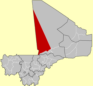
Goundam Cercle is a second-level administrative subdivision (cercle) of the Tombouctou Region in northern Mali. Its administrative center is the town of Goundam, although the most populous commune is Tonka. In the 2009 census, the cercle had a population of 150,150.

Bougouni Cercle is an administrative subdivision of the Sikasso Region of Mali. The administrative center (chef-lieu) is the town of Bougouni.

Kadiolo Cercle is an administrative subdivision of the Sikasso Region of southern Mali. The administrative center (chef-lieu) is the town of Kadiolo.

Yorosso Cercle is an administrative subdivision of the Sikasso Region of southern Mali. The main town (chef-lieu) is Yorosso.

San Cercle is an administrative subdivision of the Ségou Region of Mali. The administrative center (chef-lieu) is the town of San.

Tominian Cercle is an administrative subdivision of the Ségou Region of Mali. The administrative center of the local government is in the town of Tominian. The Cercle is divided into Communes, and below this, quarters/villages. In the 2009 census the cercle had a population of 219,853 people.

Bandiagara Cercle is an administrative subdivision of the Mopti Region of Mali. The administrative center (chef-lieu) is the town of Bandiagara.

Koro Cercle is an administrative subdivision of the Mopti Region of Mali. The administrative center is the town of Koro.

Mopti Cercle is an administrative subdivision of the Mopti Region of Mali. The administrative center (chef-lieu) is the town of Mopti.

Youwarou Cercle is an administrative subdivision of the Mopti Region of Mali. The administrative center (chef-lieu) is the town of Youwarou.

Gourma-Rharous Cercle is an administrative subdivision of the Tombouctou Region of Mali. The administrative center is the town of Gourma-Rharous.

Niafunké Cercle is an administrative subdivision of the Tombouctou Region of Mali. The administrative center (chef-lieu) is the town of Niafunké. In the 2009 census the cercle had a population of 184,285. The Niger River runs for 100 km through the cercle.
Dialloubé is a small town and rural commune in the Cercle of Mopti in the Mopti Region of Mali. The commune covers an area of approximately 1,425 square kilometers and includes the town and 8 villages. In the 2009 census the commune had a population of 13,727.
Koubewel Koundia is a rural commune in the Cercle of Douentza in the Mopti Region of Mali. The commune contains 14 villages and had a population of 13,529 in the 2009 census. The main village (chef-lieu) is Koubewel.
Pétaka is a village and rural commune in the Cercle of Douentza in the Mopti Region of Mali. The commune contains five villages and had a population of 6,010 in the 2009 census.
Pel Maoudé is a village and rural commune and seat of the Cercle of Koro in the Mopti Region of Mali. The commune covers an area of approximately 203 square kilometers and includes 9 villages. In the 2009 census the commune had a population of 13,727.
Djaptodji is a rural commune of the Cercle of Douentza in the Mopti Region of Mali. The commune contains 64 small villages and in the 2009 census had a population of 36,263. The principal village (chef-lieu) is N'Gouma.
Dougoutene II is a rural commune of the Cercle of Koro in the Mopti Region of Mali. The commune contains 20 villages and in the 2009 census had a population of 20,115. The commune is administered from Andiagana-Na.

Bambara Maoudé or Bambara Maoundé is a village and rural commune of the Cercle of Gourma-Rharous in the Tombouctou Region of Mali. The commune contains 44 villages and had a population of 16,874 in the 2009 census.