
Mopti is the fifth administrative region of Mali, covering 79,017 km2. Its capital is the city of Mopti. During the 2012 Northern Mali conflict, the frontier between Southern Mali which is controlled by the central government and the rebel-held North ran through Mopti Region.

Mopti is a town and an urban commune in the Inner Niger Delta region of Mali. The town is the capital of the Mopti Cercle and the Mopti Region. Situated 630 km northeast of Bamako, the town lies at the confluence of the Niger and the Bani Rivers and is linked by an elevated causeway to the town of Sévaré. The urban commune, which includes both Mopti and Sévaré, had a population of 114,296 in the 2009 census.

Hombori is a small town and rural commune in the Cercle of Douentza in the Mopti Region of Mali. The commune contains 25 villages and in the 2009 census had a population of 23,099. The town lies just to the north of the Hombori Tondo mesa on the R15 highway linking Mopti and Gao.

Douentza is a town and urban commune in the Mopti Region of central Mali. The town lies 145 km east-northeast of Mopti on the RN16, a paved road that links Mopti and Gao. It is the administrative center of the Douentza Cercle.
Doucoumbo or Doucombo is a village and rural commune in the Bandiagara Cercle of the Mopti Region of Mali. The commune contains 24 villages and at the time of the 2009 census had a population of 11,510. The village of Doucoumbo is 5 km west of Bandiagara on the RN15 that links Bandiagara to Sévaré.
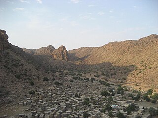
Borko is a village and rural commune in the Cercle of Bandiagara of the Mopti Region of Mali. The village lies on the edge of the Dogon Plateau, 105 km northwest of Mopti and 73 km north-northwest of Bandiagara. In the 2009 census the commune had a population of 6,254. The village is set in a valley, and is only accessible by one entrance.
Bassirou is a commune in the Cercle of Mopti in the Mopti Region of Mali. The main village of Sampara is located 20 km north of Sévaré between the RN15 and the Niger River. In 2009 the commune had a population of 2,064.
Diamnati is a commune in the Cercle of Bandigara in the Mopti Region of Mali. The commune contains 11 villages and at the time of the 2009 census had a population of 13,349. The main village of Dé lies 62 km northeast of Bandiagara.
Dallah is a village and rural commune in the Cercle of Douentza in the Mopti Region of Mali. The village is located close to the southern edge of the Gandamia Massif, an inselberg that rises 750 m above the plain. The massif extends for 60 km in an east-west direction and 10 km north to south. The metalled road, the RN16, that run between Mopti and Gao passes to the south of the village. The commune contains 12 villages and in the 2009 census had a population of 8,504.
Débéré is a village and rural commune in the Cercle of Douentza in the Mopti Region of Mali. The commune contains seven villages and in the 2009 census had a population of 5,760. Fulfulde is the main language spoken in the village.
Kéréna or Kerana is a village and rural commune in the Cercle of Douentza in the Mopti Region of Mali. Fulfulde is the main language spoken in the village. The commune contains three villages and in the 2009 census had a population of 3,289.
Toguéré Coumbé is a village and commune of the Cercle of Ténenkou in the Mopti Region of Mali. The commune contains 32 villages and in 2009 had a population of 27,057.
Femaye is a rural commune of the Cercle of Djenné in the Mopti Region of Mali. The commune includes 21 villages. The principal village (chef-lieu) is Taga.
Togué Mourari is a rural commune of the Cercle of Djenné in the Mopti Region of Mali. The commune contains 11 villages. The administrative center (chef-lieu) is the village of Mourrah.
Tédié or Tédjé is a rural commune of the Cercle of Douentza in the Mopti Region of Mali. The commune contains 12 villages and in the 2009 census had a population of 6,733. The principal village (chef-lieu) is Tongo-Tongo.
Dé is a village and seat of the commune of Diamnati in the Cercle of Bandiagara of the Mopti Region of southern-central Mali.
Boni is a village and seat of the commune of Hairé in the Cercle of Douentza in the Mopti Region of southern-central Mali. The village is 5 km south of the main road, the RN15, that links Mopti and Gao. This is the only paved road in this part of Mali.
Soufouroulaye is a village and seat of the commune of Sio in the Cercle of Mopti in the Mopti Region of southern-central Mali.
Dia (Jà) is a small town and seat of the commune of Diaka in the Cercle of Ténenkou in the Mopti Region of southern-central Mali.

Tondi Songway Kiini is a variety of Southern Songhai spoken in several villages in the area of Kikara, Mali, about 120 km west of Hombori. Westerners documented the existence of Tondi Songway Kiini in 1998.

