
Mopti is the fifth administrative region of Mali, covering 79,017 km2. Its capital is the city of Mopti. During the 2012 Northern Mali conflict, the frontier between Southern Mali which is controlled by the central government and the rebel-held North ran through Mopti Region.

Bandiagara is a small town and urban commune in the Mopti Region of Mali. The name translates roughly to "large eating bowl"—referring to the communal bowl meals are served in. Mainly on its Bandiagara Escarpment it has about 2,000 speakers of the vibrant Bangime language, an isolate used mainly as an anti-language; it has the highest point of the country.

Bandiagara Cercle is an administrative subdivision of the Mopti Region of Mali. The administrative center (chef-lieu) is the town of Bandiagara.

Doucoumbo or Doucombo is a village and rural commune in the Bandiagara Cercle of the Mopti Region of Mali. The commune contains 24 villages and at the time of the 2009 census had a population of 11,510. The village of Doucoumbo is 5 km west of Bandiagara on the RN15 that links Bandiagara to Sévaré.
Dourou (Dúrù) is a village and rural commune in the Bandiagara Cercle of the Mopti Region of Mali. The commune contains 28 villages along the Bandiagara Escarpment which together at the time of the 2009 census had a population of 19,411. Around 95 percent of the population is Dogon with the remainder being Fulani.
Dogani Béré (Dògàn-bɛ̀lɛ́) is a village and rural commune in the Cercle of Bandiagara of the Mopti Region of Mali. The commune contains five villages and at the time of the 2009 census had a population of 2400. The village cluster is called Dogani, while Dogani Béréw is the name of the main village. The other villages are Menthi, Kounde, Gobina, and Sirou.
Kendé is a village and rural commune in the Cercle of Bandiagara of the Mopti Region of Mali.> The commune contains five villages and at the time of the 2009 census had a population of 7,372.
Pelou (Pɛ̀:lú) is a village and rural commune in the Cercle of Bandiagara of the Mopti Region of Mali. The commune contains four villages and in the 2009 census had a population of 4,348.
Soroly (Sóllù) is a village and commune in the Cercle of Bandiagara of the Mopti Region of Mali. It is situated on a rocky plateau. Donno So is spoken in the village. Local surnames are Guindo, Tapily, Kélépily, and Kassogué. The commune contains nine villages and in the 2009 census had a population of 7,885.
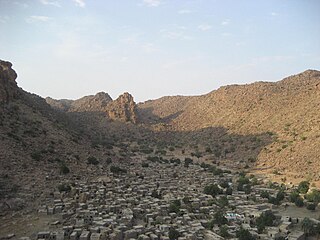
Borko is a village and rural commune in the Cercle of Bandiagara of the Mopti Region of Mali. The village lies on the edge of the Dogon Plateau, 105 km northwest of Mopti and 73 km north-northwest of Bandiagara. In the 2009 census the commune had a population of 6,254. The village is set in a valley, and is only accessible by one entrance.
Ondougou or Onjougou (ɔ̀njɔ́gɔ̀) is a rural commune in the Cercle of Bandiagara in the Mopti Region of Mali. The commune contains nine villages and in the 2009 census had a population of 7,182. The main village (chef-lieu) is Banakane. Goundaka is located near Ondougou.
Kendié or Kenndié (Kènjé) is a village and rural commune in the Cercle of Bandiagara of the Mopti Region of Mali. The commune contains 34 villages and had a population of 24,359 in the 2009 census.
Fatoma is a village and commune in the Cercle of Mopti in the Mopti Region of Mali. The commune contains 24 villages and in 2009 had a population of 24,595. The village of Fatoma lies 10 kilometres north of Sévaré.
Bassirou is a commune in the Cercle of Mopti in the Mopti Region of Mali. The main village of Sampara is located 20 km north of Sévaré between the RN15 and the Niger River. In 2009 the commune had a population of 2,064.
Korombana is a commune in the Cercle of Mopti in the Mopti Region of Mali. It is the most northerly commune in the cercle. The commune contains 32 villages and in 2009 had a population of 29,559. The main village (chef-lieu) is Korientzé.
Diamnati is a commune in the Cercle of Bandigara in the Mopti Region of Mali. The commune contains 11 villages and at the time of the 2009 census had a population of 13,349. The main village of Dé lies 62 km northeast of Bandiagara.
Dandougou Fakala is a rural commune in the Cercle of Djenné in the Mopti Region of Mali. The commune contains ten villages. The administrative center (chef-lieu) is the village of Konio. In the 2009 census the commune had a population of 9,841.
Pel Maoudé is a village and rural commune and seat of the Cercle of Koro in the Mopti Region of Mali. The commune covers an area of approximately 203 square kilometers and includes 9 villages. In the 2009 census the commune had a population of 13,727.
Bimbéré Tama is a commune of the Cercle of Youwarou in the Mopti Region of Mali. The main village (chef-lieu) is Dogo. In 2009 the commune had a population of 8,209.
Derary is a rural commune of the Cercle of Djenné in the Mopti Region of Mali. The commune contains eight villages. The administrative center (chef-lieu) is the village of Gagna. In the 2009 census the commune had a population of 6,558.

