
Bankass is a town and rural commune located in the Mopti Region of Mali. The commune has an area of approximately 362 square kilometers and includes the town and 25 of the surrounding villages. In the 2009 census it had a population of 30,159. The town is the seat of the Bankass Cercle, one of eight subdivisions (cercles) of the Mopti Region.

Goundam is a commune and town in north central Mali, in the Tombouctou Region. It is the capital of Goundam Cercle, one of five subdivisions of the Region. In the 2009 census the commune had a population of 16,253. The main ethnic groups are Songhay, Tuareg and Fulani.

Bandiagara Cercle is an administrative subdivision of the Mopti Region of Mali. The administrative center (chef-lieu) is the town of Bandiagara.

Douentza Cercle is an administrative subdivision of the Mopti Region of Mali. The administrative center (chef-lieu) is the town of Douentza.

Mopti Cercle is an administrative subdivision of the Mopti Region of Mali. The administrative center (chef-lieu) is the town of Mopti.
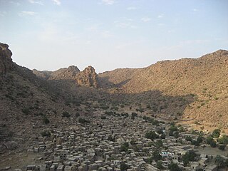
Borko is a village and rural commune in the Cercle of Bandiagara of the Mopti Region of Mali. The village lies on the edge of the Dogon Plateau, 105 km northwest of Mopti and 73 km north-northwest of Bandiagara. In the 2009 census the commune had a population of 6,254. The village is set in a valley, and is only accessible by one entrance.
Bassirou is a commune in the Cercle of Mopti in the Mopti Region of Mali. The main village of Sampara is located 20 km north of Sévaré between the RN15 and the Niger River. In 2009 the commune had a population of 2,064.
Ténenkou is a village and commune and seat of the Ténenkou Cercle in the Mopti Region of Mali. In 2009 the commune had a population of 11,310.
Bimbéré Tama is a commune of the Cercle of Youwarou in the Mopti Region of Mali. The main village (chef-lieu) is Dogo. In 2009 the commune had a population of 8,209.
Dangol Boré is a rural commune of the Cercle of Douentza in the Mopti Region of Mali. The commune contains 34 villages and in the 2009 census had a population of 27,165. The principal village (chef-lieu) is Boré.
Bamba is a rural commune of the Cercle of Koro in the Mopti Region of Mali. The commune contains 14 villages and in the 2009 census had a population of 13,610. Most of the population of the commune are Dogon. The administrative centre (chef-lieu) is the village of Déguéré.
Dougoutene II is a rural commune of the Cercle of Koro in the Mopti Region of Mali. The commune contains 20 villages and in the 2009 census had a population of 20,115. The commune is administered from Andiagana-Na.
Gagna is a village and seat (chef-lieu) of the rural commune of Derary in the Cercle of Djenné in the Mopti Region of southern-central Mali.
Taga is a village and seat of the commune of Femaye in the Cercle of Djenné in the Mopti Region of southern-central Mali.
Mougna is a village and seat of the rural commune of Néma-Badenyakafo in the Cercle of Djenné in the Mopti Region of southern-central Mali.
Senossa is a village and seat of the commune of Ouro Ali in the Cercle of Djenné in the Mopti Region of southern-central Mali.
Sofara is a small town and seat (chef-lieu) of the rural commune of Fakala in the Cercle of Djenné in the Mopti Region of southern-central Mali. The town lies on the right bank of the Bani River. A weekly market is held in the town on Tuesdays that serves the settlements in the region.


