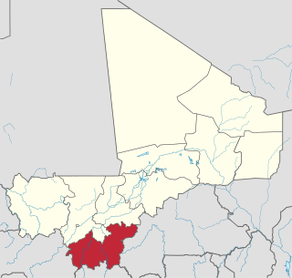
Sikasso Region is the southernmost region of Mali. The region's capital city, Sikasso, is the country's second-largest city. Major ethnic groups include the Senoufo, known for masks and reverence for animals, the Samago, known for being Mali's best farmers, and the main ethnic group in Mali, the Bambara people.
Niéna is a small town and rural commune in the Cercle of Sikasso in the Sikasso Region of southern Mali. The commune covers an area of 1,040 square kilometers and includes the town and 42 villages. In the 2009 census it had a population of 32,265. The town is the administrative center (chef-lieu) of the commune. It is 76 km west of Sikasso on the RN7, the main road linking Sikasso and Bougouni.
Yorosso is a town and rural commune in the Yorosso Cercle, in the Sikasso Region of southern Mali. The town serves as the seat of the Yorosso Cercle. It lies 151 km northeast of Sikasso and 202 km southeast of Ségou. The commune covers an area of 487 square kilometers, and includes the Yorosso town and nine other surrounding villages. According to the 2009 census, it had a population of 22,063.

Kolondiéba Cercle is an administrative subdivision of the Sikasso Region of Mali. The administrative center (chef-lieu) is the town of Kolondiéba.

Kadiolo Cercle is an administrative subdivision of the Sikasso Region of southern Mali. The administrative center (chef-lieu) is the town of Kadiolo.
Koutiala Cercle is an administrative subdivision of the Sikasso Region of southern Mali. The administrative center is the town of Koutiala. The Cercle is divided into 36 communes.

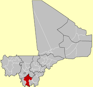
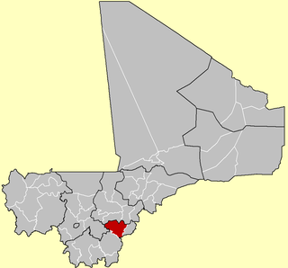
Sikasso Cercle is one of seven administrative subdivisions of the Sikasso Region of southern Mali. The capital is the town of Sikasso.

Yanfolila Cercle is an administrative subdivision of the Sikasso Region of southern Mali. The administrative center (chef-lieu) is the town of Yanfolila.

Yorosso Cercle is an administrative subdivision of the Sikasso Region of southern Mali. The main town (chef-lieu) is Yorosso.
Zaniéna is a village and rural commune in the Cercle of Sikasso in the Sikasso Region of southern Mali. The commune covers an area of 174 square kilometers and includes ten villages. In the 2009 census it had a population of 10,038. The village of Zaniéna, the administrative center (chef-lieu) of the commune, is 83 km west of Sikasso.
Zanférébougou is a village and rural commune in the Cercle of Sikasso in the Sikasso Region of southern Mali. The commune covers an area of 68 square kilometers and includes three villages. In the 2009 census it had a population of 7,275. The village of Zanférébougou, the administrative center (chef-lieu) of the commune, is 44 km west of Sikasso and 7 km south of the RN7, the main road linking Sikasso and Bougouni.
Farakala is a village and commune in the Cercle of Sikasso in the Sikasso Region of southern Mali. The commune covers an area of 280 square kilometers (110 sq mi) and includes 11 villages. In the 2009 census it had a population of 7,960. The village of Farakala lies 40 km (25 mi) west of Sikasso on the RN7 highway linking Sikasso and Bougouni.
Nongo-Souala is a village rural commune in the Cercle of Sikasso in the Sikasso Region of southern Mali. The commune covers an area of 264 square kilometers and includes four villages. In the 2009 census it had a population of 4,578. The village of Nongo-Souala, the administrative center (chef-lieu) of the commune, is 50 km north of Sikasso.
Natien is a village and rural commune in the Cercle of Sikasso in the Sikasso Region of southern Mali. The commune covers an area of 207 square kilometers and includes 9 villages. In the 2009 census it had a population of 7,404. The village of Natien, the administrative center (chef-lieu) of the commune, is 18 km west of Sikasso on the RN7, the main road linking Sikasso and Bougouni.
Sokourani-Missirikoro is a village and rural commune in the Cercle of Sikasso in the Sikasso Region of southern Mali. The commune covers an area of 88 square kilometers and includes five villages. In the 2009 census it had a population of 4,478. The village of Sokourani-Missirikoro, the administrative center (chef-lieu) of the commune, is 13 km southwest of Sikasso. The main language spoken in the commune is Senufo.
Kapolondougou is a rural commune in the Cercle of Sikasso in the Sikasso Region of southern Mali. The commune covers an area of 526 square kilometers and includes 19 villages. In the 2009 census it had a population of 12,605. The main village (chef-lieu) is N'Kourala. It lies 50 km west of Sikasso on the main road, the RN7, linking Sikasso and Bougouni.
Finkolo Ganadougou is a rural commune in the Cercle of Sikasso in the Sikasso Region of southern Mali. The commune covers an area of 464 square kilometers and includes the 16 villages. In the 2009 census it had a population of 8,498. The main village (chef-lieu) is the village of Finkolo. The village of Finkolo, the chef-lieu of the commune, is 59 km west of Sikasso.
Benkadi is a rural commune in the Cercle of Sikasso in the Sikasso Region of southern Mali. The commune covers an area of 175 square kilometers and includes 7 villages. In the 2009 census it had a population of 3,077. The main village (chef-lieu) of Koungoba is 89 km west-northwest of Sikasso.
Tiankadi is a commune in the Cercle of Sikasso in the Sikasso Region of southern Mali. The commune covers an area of 70 square kilometers and includes three villages. In the 2009 census it had a population of 4,674. The village of Zibangolola, the administrative center (chef-lieu) of the commune, is 60 km northwest of Sikasso.
Wassoulou-Ballé is a rural commune in the Cercle of Yanfolila in the Sikasso Region of southern Mali. The administrative center (chef-lieu) of the commune is the town of Yanfolila. The town is also the administrative center of the cercle. It lies 272 km west of Sikasso, 164 km south of Bamako and 23 km from the border with Guinea. The commune covers an area of 1,594 square kilometers and includes the town of Yanfolila and 29 villages. In the 2009 census it had a population of 51,727.