N'Tossoni is a village and rural commune in the Cercle of Koutiala in the Sikasso Region of southern Mali. The commune covers an area of 155 square kilometers and includes 5 villages. In the 2009 census it had a population of 8,793. The village of N'Tossoni, the administrative centre (chef-lieu) of the commune, is about 40 km northwest of Koutiala.
Karagouana Mallé is a rural commune and village in the Cercle of Koutiala in the Sikasso Region of southern Mali. The commune covers an area of 182 square kilometers and includes 5 villages. In the 2009 census it had a population of 7,520. The village of Karagouana Mallé, the administrative centre (chef-lieu) of the commune, is 38 km northwest of Koutiala.
Kouniana is a village and commune in the Cercle of Koutiala in the Sikasso Region of southern Mali. The commune covers an area of 79 square kilometers and includes 2 settlements. In the 2009 census it had a population of 3,294. The village of Kouniana, the administrative centre (chef-lieu) of the commune, is 45 km northeast of Koutiala.
Sorobasso is a village and commune in the Cercle of Koutiala in the Sikasso Region of southern Mali. The commune covers an area of 133 square kilometers and includes 5 villages. In the 2009 census it had a population of 4,884. The village of Sorobasso, the administrative centre (chef-lieu) of the commune, is 30 km northeast of Koutiala on the Route Nationale 13 that links Koutiala with San.
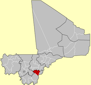
Sincina is a small town and commune in the Cercle of Koutiala in the Sikasso Region of southern Mali. The commune covers an area of 210 square kilometers and includes 7 settlements. In the 2009 census it had a population of 17,025. The town of Sincina, the administrative centre (chef-lieu) of the commune, is only 5 km southeast of the center of Koutiala. As Koutiala expands the commune will become a suburb of the town.
Konséquéla is a town and rural commune in the Cercle of Koutiala in the Sikasso Region of southern Mali. The commune covers an area of 656 square kilometers and includes 16 settlements. In the 2009 census it had a population of 31,007. The town of Konséquéla, the administrative centre (chef-lieu) of the commune, is 45 km west of Koutiala.
Konina is a small town and commune in the Cercle of Koutiala in the Sikasso Region of southern Mali. The commune covers an area of 733 square kilometers and includes 7 villages. In the 2009 census it had a population of 14,786. The village of Konina, the administrative centre (chef-lieu) of the commune, is 78 km east of Koutiala.
Sinkolo is a village and rural commune in the Cercle of Koutiala in the Sikasso Region of southern Mali. The commune covers an area of 296 square kilometers and includes 9 villages. In the 2009 census it had a population of 11,470. The village of Sinkolo, the administrative centre (chef-lieu) of the commune, is 35 km south-southwest of Koutiala.
Kafo Faboli is a commune in the Cercle of Koutiala in the Sikasso Region of southern Mali. The commune covers an area of 217 square kilometers and includes 10 villages. In the 2009 census it had a population of 8,130. The village of Peguena, the administrative centre (chef-lieu) of the commune, is 60 km northwest of Koutiala.
Zanina is a commune in the Cercle of Koutiala in the Sikasso Region of southern Mali. The commune covers an area of 125 square kilometers and includes 3 villages. In the 2009 census it had a population of 7,492. The village of Débéla, the administrative centre (chef-lieu) of the commune, is 45 km northwest of Koutiala.
Tao is a commune in the Cercle of Koutiala in the Sikasso Region of southern Mali. The commune covers an area of 67 square kilometers and includes 3 villages. In the 2009 census it had a population of 7,047. The village of Fonfona, the administrative centre (chef-lieu) of the commune, is 45 km northwest of Koutiala.
Fakolo is a commune in the Cercle of Koutiala in the Sikasso Region of southern Mali. The commune covers an area of 201 square kilometers and includes 6 villages. In the 2009 census it had a population of 13,130. The village of Zansoni, the administrative centre (chef-lieu) of the commune, is 35 km northwest of Koutiala.
Gouadji Kao is a commune in the Cercle of Koutiala in the Sikasso Region of southern Mali. The commune covers an area of 150 square kilometers and includes 5 villages. In the 2009 census it had a population of 10,579. The village of N'Togonasso, the administrative centre (chef-lieu) of the commune, is 42 km northeast of Koutiala.
Songo-Doubacoré is a commune in the Cercle of Koutiala in the Sikasso Region of southern Mali. The commune covers an area of 232 square kilometers and includes 11 villages. In the 2009 census it had a population of 14,007. The village of Oula, the administrative centre (chef-lieu) of the commune, is 26 km northeast of Koutiala.
Yognogo is a commune in the Cercle of Koutiala in the Sikasso Region of southern Mali. The commune covers an area of 66 square kilometers and includes 3 villages. In the 2009 census it had a population of 5,700. The village of Famessasso, the administrative centre (chef-lieu) of the commune, is 20 km northeast of Koutiala near the Route Nationale 13 that links Koutiala with San.
Songoua is a commune in the Cercle of Koutiala in the Sikasso Region of southern Mali. The commune covers an area of 107 square kilometers and includes the villages of Sirakélé and Kilé. In the 2009 census it had a population of 6,918. The village of Sirakélé, the administrative centre (chef-lieu) of the commune, is 15 km north of Koutiala.
Koningué is a commune in the Cercle of Koutiala in the Sikasso Region of southern Mali. The commune covers an area of 255 square kilometers and includes 4 settlements. In the 2009 census it had a population of 15,943. The small town of Sougoumba, the administrative centre (chef-lieu) of the commune, is about 40 km southeast of Koutiala.
Goudie Sougouna is a commune in the Cercle of Koutiala in the Sikasso Region of southern Mali. The commune covers an area of 267 square kilometers and includes 6 villages. In the 2009 census it had a population of 8,303. The village of Sanguela, the administrative centre (chef-lieu) of the commune, is 57 km southeast of Koutiala.
Diouradougou Kafo is a commune in the Cercle of Koutiala in the Sikasso Region of southern Mali. The commune covers an area of 402 square kilometers and includes 10 villages. In the 2009 census it had a population of 6,876. The village of Tièrè, the administrative centre (chef-lieu) of the commune, is 80 km south of Koutiala.
Fagui is a commune in the Cercle of Koutiala in the Sikasso Region of southern Mali. The commune covers an area of 504 square kilometers and includes 9 villages. In the 2009 census it had a population of 11,800. The village of Ziéna, the administrative centre (chef-lieu) of the commune, is 45 km southwest of Koutiala.