
Sikasso Cercle is one of seven administrative subdivision of the Sikasso Region of southern Mali. The capital is the town of Sikasso.

Kadiolo is a town, rural commune and seat of the Kadiolo Cercle in the Sikasso Region of southern Mali. The town lies 85 km south of Sikasso, 13 km north of the border with the Ivory Coast and 30 km west of the border with Burkino Faso. The commune of Kadiolo covers an area of 783 square kilometers and includes the town and 19 villages. In the 2009 census it had a population of 59,932.

Fourou is a town and rural commune in the Cercle of Kadiolo in the Sikasso Region of southern Mali near the border with Ivory Coast. The commune covers an area of 1,334 square kilometers and includes the town and 22 villages. In the 2009 census it had a population of 40,826. The town of Fourou, the administrative center (chef-lieu) of the commune, is 47 km northwest of Kadiolo.
Loulouni is a small town and rural commune in the Cercle of Kadiolo in the Sikasso Region of southern Mali. The commune covers an area of 1,052 square kilometers and includes the town and 28 villages. In the 2009 census it had a population of 38,919. The town of Loulouni, the administrative center (chef-lieu) of the commune, is 41 km north-northeast of Kadiolo on the RN7, the main road between Sikasso and Ouangolodougou in the Ivory Coast.
Zangasso is a small town and commune in the Cercle of Koutiala in the Sikasso Region of southern Mali. The commune covers an area of 452 square kilometers and includes 10 settlements. In the 2009 census it had a population of 19,925. The small town of Zangasso, the administrative centre (chef-lieu) of the commune, is 30 km southwest of Koutiala on the Route Nationale 11 that links Koutiala with Sikasso.
Lobougoula is a small town and rural commune in the Cercle of Sikasso in the Sikasso Region of southern Mali. The commune covers an area of 1418 square kilometers and includes the town and 31 villages. In the 2009 census it had a population of 32,505. The town of Lobougoula, the chef-lieu of the commune, is 49 km southwest of Sikasso.
Kignan is a small town and rural commune in the Cercle of Sikasso in the Sikasso Region of southern Mali. The commune covers an area of 646 square kilometers and includes the town and 14 villages. As of the 2009 census it had a population of 33,962. The town of Kignan is 77 km northwest of Sikasso on the R20 road that links Sikasso to Fana.
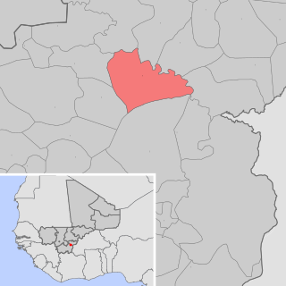
Danderesso is a small town and rural commune in the Cercle of Sikasso in the Sikasso Region of southern Mali. The commune covers an area of 1,645 square kilometers and includes the town and 30 villages. In the 2009 census it had a population of 41,723. The town of Danderesso, the chef-lieu of the commune, is 28 km northeast of Sikasso.
Kléla is a small town and rural commune in the Cercle of Sikasso in the Sikasso Region of southern Mali. The commune covers an area of 786 square kilometers and includes the town and 13 villages. In the 2009 census it had a population of 31,334. The town of Kléla is 43 km north of Sikasso.
Kouoro is a small town and rural commune in the Cercle of Sikasso in the Sikasso Region of southern Mali. The commune covers an area of 472 square kilometers and includes the town and five villages. In the 2009 census it had a population of 11,315. The town of Kouoro, the chef-lieu of the commune, is 75 km north of Sikasso, on the RN11, the main road linking Sikasso and Koutiala. It is also about 30 km west of the border with Burkina Faso.
Dogoni is a small town and rural commune in the Cercle of Sikasso in the Sikasso Region of southern Mali. The commune covers an area of 361 square kilometers and includes the town and 12 villages. In the 2009 census it had a population of 15,186. The town of Dogoni, the chef-lieu of the commune, is 100 km north-northwest of Sikasso.
Dembela is a small town and rural commune in the Cercle of Sikasso in the Sikasso Region of southern Mali. The commune covers an area of 426 square kilometers and includes 11 villages. In the 2009 census it had a population of 13,061. The village of Dembela, the chef-lieu of the commune, is 88 km northwest of Sikasso.
Fama is a small town and rural commune in the Cercle of Sikasso in the Sikasso Region of southern Mali. The commune covers an area of 222 square kilometers and includes the town and five villages. In the 2009 census it had a population of 7,960. The town of Fama, the chef-lieu of the commune, is 24 km north of Sikasso.
Blendio is a small town and rural commune in the Cercle of Sikasso in the Sikasso Region of southern Mali. The commune covers an area of 369 square kilometers and includes the town and 13 villages. In the 2009 census it had a population of 18,207. The town of Blendio, the chef-lieu of the commune, is 81 km west-northwest of Sikasso.
Kiffosso I is a village and rural commune in the Cercle of Yorosso in the Sikasso Region of southern Mali. The commune covers an area of 446 square kilometers and includes 10 villages. In the 2009 census it had a population of 15,502. The village of Kiffosso I, the administrative center (chef-lieu) of the commune, is 21 km northeast of Yorosso.
Bongosso is a village and seat (chef-lieu) of the commune of Koromo in the Cercle of Koutiala in the Sikasso Region of southern Mali. The village is 45 km northeast of Koutiala.
Sirakélé is a village and seat of the commune of Songoua in the Cercle of Koutiala in the Sikasso Region of southern Mali. The village is 15 km north of Koutiala.
Baramba is a village and administrative centre (chef-lieu) of the commune of Nampé in the Cercle of Koutiala in the Sikasso Region of southern Mali. The village is 25 km north of Koutiala.
Sah is a village and seat of the commune of N'Dodjiga in the Cercle of Youwarou in the Mopti Region of southern-central Mali. The village lies on the east (right) bank of the Bara-Issa, the smaller of the two branches of the Niger River that flow north out of Lake Débo.
Koloni is a village and administrative centre (chef-lieu) of the commune of Niantaga in the Cercle of Koutiala in the Sikasso Region of southern Mali. The village is 45 km north-northeast of Koutiala.

