
Tombouctou Region is one of the administrative regions of Mali. It is the largest of Mali's eight regions and includes a large section of the Sahara Desert. For administrative purposes, the region is subdivided into five cercles.

Koumantou is a commune and town in Mali, in the Cercle of Bougouni in the Sikasso Region. It is located near the Ivorian border.

Fourou is a town and rural commune in the Cercle of Kadiolo in the Sikasso Region of southern Mali. The commune covers an area of 1,334 square kilometers and includes the town and 22 villages. In the 2009 census it had a population of 40,826. The town of Fourou, the administrative center (chef-lieu) of the commune, is 47 km northwest of Kadiolo.
Kapala is a village and commune in the Cercle of Koutiala in the Sikasso Region of southern Mali. The commune covers an area of 199 square kilometers and includes 4 villages. In the 2009 census the commune had a population of 4,064. The village of Kapala, the administrative centre (chef-lieu) of the commune, is about 20 km south of Koutiala.
Zangasso is a small town and commune in the Cercle of Koutiala in the Sikasso Region of southern Mali. The commune covers an area of 452 square kilometers and includes 10 settlements. In the 2009 census it had a population of 19,925. The small town of Zangasso, the administrative centre (chef-lieu) of the commune, is 30 km southwest of Koutiala on the Route Nationale 11 that links Koutiala with Sikasso.
Doumanaba is a small town and rural commune in the Cercle of Sikasso in the Sikasso Region of southern Mali. The commune covers an area of 288 square kilometers and includes the town and seven villages. In the 2009 census it had a population of 15,105. The town of Doumanaba, the chef-lieu of the commune, is 49 km northwest of Sikasso.
Kouoro is a small town and rural commune in the Cercle of Sikasso in the Sikasso Region of southern Mali. The commune covers an area of 472 square kilometers and includes the town and five villages. In the 2009 census it had a population of 11,315. The town of Kouoro, the chef-lieu of the commune, is 75 km north of Sikasso, on the RN11, the main road linking Sikasso and Koutiala. It is also about 30 km west of the border with Burkina Faso.
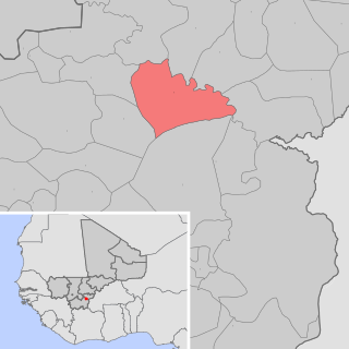
Dogoni is a small town and rural commune in the Cercle of Sikasso in the Sikasso Region of southern Mali. The commune covers an area of 361 square kilometers and includes the town and 12 villages. In the 2009 census it had a population of 15,186. The town of Dogoni, the chef-lieu of the commune, is 100 km north-northwest of Sikasso.
Dembela is a small town and rural commune in the Cercle of Sikasso in the Sikasso Region of southern Mali. The commune covers an area of 426 square kilometers and includes 11 villages. In the 2009 census it had a population of 13,061. The village of Dembela, the chef-lieu of the commune, is 88 km northwest of Sikasso.
Fama is a small town and rural commune in the Cercle of Sikasso in the Sikasso Region of southern Mali. The commune covers an area of 222 square kilometers and includes the town and five villages. In the 2009 census it had a population of 7,960. The town of Fama, the chef-lieu of the commune, is 24 km north of Sikasso.
Kafouziéla is a village and rural commune in the Cercle of Sikasso in the Sikasso Region of southern Mali. The commune covers an area of 59 square kilometers and includes six villages. In the 2009 census it had a population of 4,589. The village of Kafouziéla, the chef-lieu of the commune, is 14 km north of Sikasso.
Diomaténé is a village and rural commune in the Cercle of Sikasso in the Sikasso Region of southern Mali. The commune covers an area of 96 square kilometers and includes four villages. In the 2009 census it had a population of 4,274. The village of Diomaténé, the chef-lieu of the commune, is 11 km north of Sikasso.
Koury is a small town and rural commune in the Cercle of Yorosso in the Sikasso Region of southern Mali. The commune covers an area of 712 square kilometers and includes the town and 16 villages. In the 2009 census it had a population of 54,435. The town, the administrative center (chef-lieu) of the commune, is 19 km south of Yorosso on the main road linking Koutiala in Mali with the town of Bobo-Dioulasso in Burkina Faso.
Finkolo Ganadougou is a rural commune in the Cercle of Sikasso in the Sikasso Region of southern Mali. The commune covers an area of 464 square kilometers and includes the 16 villages. In the 2009 census it had a population of 8,498. The main village (chef-lieu) is the village of Finkolo. The village of Finkolo, the chef-lieu of the commune, is 59 km west of Sikasso.
Bongosso is a village and seat (chef-lieu) of the commune of Koromo in the Cercle of Koutiala in the Sikasso Region of southern Mali. The village is 45 km northeast of Koutiala.
Sirakélé is a village and seat of the commune of Songoua in the Cercle of Koutiala in the Sikasso Region of southern Mali. The village is 15 km north of Koutiala.
Baramba is a village and administrative centre (chef-lieu) of the commune of Nampé in the Cercle of Koutiala in the Sikasso Region of southern Mali. The village is 25 km north of Koutiala.
Koloni is a village and administrative centre (chef-lieu) of the commune of Niantaga in the Cercle of Koutiala in the Sikasso Region of southern Mali. The village is 45 km north-northeast of Koutiala.


