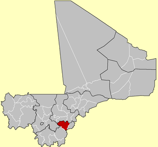
Bougouni Cercle is an administrative subdivision of the Sikasso Region of Mali. The administrative center (chef-lieu) is the town of Bougouni.

Koutiala Cercle is an administrative subdivision of the Sikasso Region of southern Mali. The administrative center is the town of Koutiala. The Cercle is divided into 36 communes.

Yorosso Cercle is an administrative subdivision of the Sikasso Region of southern Mali. The main town (chef-lieu) is Yorosso.

Bla Cercle is an administrative subdivision of the Ségou Region of Mali. The administrative center (chef-lieu) is the town of Bla.

Zan Coulibaly is a commune in the Cercle of Dioïla in the Koulikoro Region of south-western Mali. The principal town lies at Marka Coungo. In 1998 the commune had a population of 10037. The commune is known for its cotton industry.
Yinindougou is a small town and commune in the Cercle of Bougouni in the Sikasso Region of southern Mali. In 1998 the commune had a population of 4,104. The commune consists of 11 villages.
Defina is a small town and commune in the Cercle of Bougouni in the Sikasso Region of southern Mali. In 1998 the commune had a population of 6,109.
Meridiela is a small town and commune in the Cercle of Bougouni in the Sikasso Region of south-western Mali. In 1998 the commune had a population of 9,037.
Faragouaran is a small town and commune in the Cercle of Bougouni in the Sikasso Region of southern Mali. In 1998 the commune had a population of 6,971.
Sido is a small town and commune in the Cercle of Bougouni in the Sikasso Region of southern Mali. In 1998 the commune had a population of 13,877.
Kokele is a small town and commune in the Cercle of Bougouni in the Sikasso Region of southern Mali. In 1998 the commune had a population of 5,753.
Faradiele is a small town and commune in the Cercle of Bougouni in the Sikasso Region of southern Mali. In 1998 the commune had a population of 2130.
Nangalasso is a small town and commune in the Cercle of Kolondieba in the Sikasso Region of southern Mali. In 1998 the commune had a population of 7,887.
Sibirila is a commune in the Cercle of Bougouni in the Sikasso Region of southern Mali. The principal town lies at Manankoro. In 1998 the commune had a population of 14,012.
Yiridougou is a commune in the Cercle of Bougouni in the Sikasso Region of southern Mali. The principal town lies at Ouroumpana. In 1998 the commune had a population of 5,992.
Danou is a commune in the Cercle of Bougouni in the Sikasso Region of southern Mali. The principal town lies at Torakoro. In 1998 the commune had a population of 8,869.
Kouroulamini is a commune in the Cercle of Bougouni in the Sikasso Region of southern Mali. The principal town lies at N'Tentou. In 1998 the commune had a population of 3,128.
N'Golodiana is a commune in the Cercle of Kolondieba in the Sikasso Region of southern Mali. The principal town lies at Toutiala. In 1998 the commune had a population of 4435.
Dougouolo is a small town and commune in the Cercle of Bla in the Ségou Region of southern-central Mali. As of 1998 the commune had a population of 7,120.
Bondo is a village and commune and seat of the Cercle of Koro in the Mopti Region of Mali. In 1998 the commune had a population of 15,872 In 2009, population was almost 20,000.


