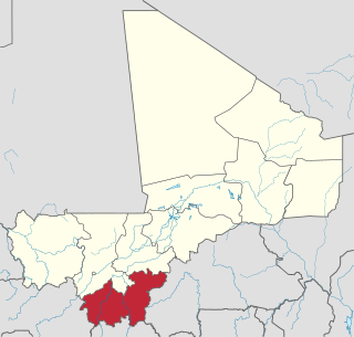
Sikasso Region is the southernmost region of Mali. The region's capital city, Sikasso, is the country's second-largest city. Major ethnic groups include the Senoufo, known for masks and reverence for animals, the Samago, known for being Mali's best farmers, and the main ethnic group in Mali, the Bambara people.
Niéna is a small town and rural commune in the Cercle of Sikasso in the Sikasso Region of southern Mali. The commune covers an area of 1,040 square kilometers and includes the town and 42 villages. In the 2009 census it had a population of 32,265. The town is the administrative center (chef-lieu) of the commune. It is 76 km west of Sikasso on the RN7, the main road linking Sikasso and Bougouni.
Zanférébougou is a village and rural commune in the Cercle of Sikasso in the Sikasso Region of southern Mali. The commune covers an area of 68 square kilometers and includes three villages. In the 2009 census it had a population of 7,275. The village of Zanférébougou, the administrative center (chef-lieu) of the commune, is 44 km west of Sikasso and 7 km south of the RN7, the main road linking Sikasso and Bougouni.
Farakala is a village and commune in the Cercle of Sikasso in the Sikasso Region of southern Mali. The commune covers an area of 280 square kilometers (110 sq mi) and includes 11 villages. In the 2009 census it had a population of 7,960. The village of Farakala lies 40 km (25 mi) west of Sikasso on the RN7 highway linking Sikasso and Bougouni.
Sanzana is a village and rural commune in the Cercle of Sikasso in the Sikasso Region of southern Mali. The commune covers an area of 326 square kilometers and includes eight villages. In the 2009 census it had a population of 11,214. The village of Sanzana, the administrative center (chef-lieu) of the commune, is 57 km northwest of region capital Sikasso.
Kourouma is a village and rural commune in the Cercle of Sikasso in the Sikasso Region of southern Mali. The commune covers an area of 293 square kilometers and includes 10 villages. In the 2009 census, it had a population of 11,234. The village of Kourouma, the chef-lieu of the commune, is 81 km northwest of Sikasso.
Tella is a village and rural commune in the Cercle of Sikasso in the Sikasso Region of southern Mali. The commune covers an area of 511 square kilometers and includes six villages. In the 2009 census it had a population of 4,372. The village of Tella, the administrative center (chef-lieu) of the commune, is 82 km northwest of Sikasso.
Koumankou is a village and rural commune in the Cercle of Sikasso in the Sikasso Region of southern Mali. The commune covers an area of 243 square kilometers and includes 4 villages. In the 2009 census it had a population of 4,227. The village of Koumankou, the chef-lieu of the commune, is 101 km northwest of Sikasso.
Gongasso is a village and rural commune in the Cercle of Sikasso in the Sikasso Region of southern Mali. The commune covers an area of 378 square kilometers and includes ten villages. In the 2009 census it had a population of 8465. The village of Gongasso lies 29 km northwest of Sikasso on the main road, the RN11, linking Sikasso and Koutiala.
Pimperna is a village and rural commune in the Cercle of Sikasso in the Sikasso Region of southern Mali. The commune covers an area of 161 square kilometers and includes 10 villages. In the 2009 census it had a population of 11,329. The village of Pimperna, the administrative center (chef-lieu) of the commune, is 16 km northwest of Sikasso on the RN11, the main road between Sikasso and Koutiala.
Natien is a village and rural commune in the Cercle of Sikasso in the Sikasso Region of southern Mali. The commune covers an area of 207 square kilometers and includes 9 villages. In the 2009 census it had a population of 7,404. The village of Natien, the administrative center (chef-lieu) of the commune, is 18 km west of Sikasso on the RN7, the main road linking Sikasso and Bougouni.
Kapala is a village and rural commune in the Cercle of Sikasso in the Sikasso Region of southern Mali. The commune covers an area of 175 square kilometers and includes eight villages. In the 2009 census it had a population of 10,200. The village of Kapala is about 25 km south of Sikasso.
Finkolo is a village and rural commune in the Cercle of Sikasso in the Sikasso Region of southern Mali. The commune covers an area of 477 square kilometers and includes 11 villages. In the 2009 census it had a population of 22,429. The village of Finoko, the chef-lieu of the commune, is 18 km east-southeast of Sikasso on the N7, the small road that links Sikasso with Bobo-Dioulasso in Burkina Faso.
Zangaradougou is a village and rural commune in the Cercle of Sikasso in the Sikasso Region of southern Mali. The commune covers an area of 99 square kilometers and includes five villages. In the 2009 census it had a population of 6,818. The village of Zangaradougou, the administrative center (chef-lieu) of the commune, is 11 km northeast of Sikasso.
Diomaténé is a village and rural commune in the Cercle of Sikasso in the Sikasso Region of southern Mali. The commune covers an area of 96 square kilometers and includes four villages. In the 2009 census, it had a population of 4,274. The village of Diomaténé, the chef-lieu of the commune, is 11 km north of Sikasso.
Blendio is a small town and rural commune in the Cercle of Sikasso in the Sikasso Region of southern Mali. The commune covers an area of 369 square kilometers and includes the town and 13 villages. In the 2009 census it had a population of 18,207. The town of Blendio, the chef-lieu of the commune, is 81 km west-northwest of Sikasso.
Zanina is a commune in the Cercle of Koutiala in the Sikasso Region of southern Mali. The commune covers an area of 125 square kilometers and includes 3 villages. In the 2009 census it had a population of 7,492. The village of Débéla, the administrative centre (chef-lieu) of the commune, is 45 km northwest of Koutiala.
Kapolondougou is a rural commune in the Cercle of Sikasso in the Sikasso Region of southern Mali. The commune covers an area of 526 square kilometers and includes 19 villages. In the 2009 census it had a population of 12,605. The main village (chef-lieu) is N'Kourala. It lies 50 km west of Sikasso on the main road, the RN7, linking Sikasso and Bougouni.
Tiankadi is a commune in the Cercle of Sikasso in the Sikasso Region of southern Mali. The commune covers an area of 70 square kilometers and includes three villages. In the 2009 census it had a population of 4,674. The village of Zibangolola, the administrative center (chef-lieu) of the commune, is 60 km northwest of Sikasso.
Wassoulou-Ballé is a rural commune in the Cercle of Yanfolila in the Sikasso Region of southern Mali. The administrative center (chef-lieu) of the commune is the town of Yanfolila. The town is also the administrative center of the cercle. It lies 272 km west of Sikasso, 164 km south of Bamako and 23 km from the border with Guinea. The commune covers an area of 1,594 square kilometers and includes the town of Yanfolila and 29 villages. In the 2009 census it had a population of 51,727.

