
Sikasso Region is the southernmost region of Mali. The region's capital city, Sikasso, is the country's second-largest city. Major ethnic groups include the Senoufo, known for masks and reverence for animals, the Samago, known for being Mali's best farmers, and the main ethnic group in Mali, the Bambara people.

Bougouni Cercle is an administrative subdivision of the Sikasso Region of Mali. The administrative center (chef-lieu) is the town of Bougouni.

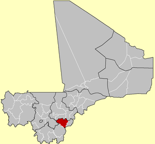
Kolondiéba Cercle is an administrative subdivision of the Sikasso Region of Mali. The administrative center (chef-lieu) is the town of Kolondiéba.
Koutiala Cercle is an administrative subdivision of the Sikasso Region of southern Mali. The administrative center is the town of Koutiala. The Cercle is divided into 36 communes.

Sikasso Cercle is one of seven administrative subdivision of the Sikasso Region of southern Mali. The capital is the town of Sikasso.

Yanfolila Cercle is an administrative subdivision of the Sikasso Region of southern Mali. The administrative center (chef-lieu) is the town of Yanfolila.

Yorosso Cercle is an administrative subdivision of the Sikasso Region of southern Mali. The main town (chef-lieu) is Yorosso.

Niafunké Cercle is an administrative subdivision of the Tombouctou Region of Mali. The administrative center (chef-lieu) is the town of Niafunké. In the 2009 census the cercle had a population of 184,285. The Niger River runs for 100 km through the cercle.
Kadiolo is a town, rural commune and seat of the Kadiolo Cercle in the Sikasso Region of southern Mali. The town lies 85 km south of Sikasso, 13 km north of the border with the Ivory Coast and 30 km west of the border with Burkino Faso. The commune of Kadiolo covers an area of 783 square kilometers and includes the town and 19 villages. In the 2009 census it had a population of 59,932.
Dioumaténé is a village and rural commune in the Cercle of Kadiolo in the Sikasso Region of southern Mali. The commune covers an area of 225 square kilometers and includes 5 villages. In the 2009 census it had a population of 4,274. The village of Dioumaténé, the administrative center (chef-lieu) of the commune, is 16 km west of Kadiolo.
Zégoua is a City and commune in the Cercle of Kadiolo in the Sikasso Region of southern Mali. The commune covers an area of 978 square kilometers and includes the town and 8 villages. In the 2017 census it had a population of 230,360. The city of Zégoua, the administrative center (chef-lieu) of the commune, is 2 km north of the border with the Ivory Coast and 14 km southeast of Kadiolo on the RN7, the main road linking Sikasso and Ouangolodougou.

Fourou is a town and rural commune in the Cercle of Kadiolo in the Sikasso Region of southern Mali near the border with Ivory Coast. The commune covers an area of 1,334 square kilometers and includes the town and 22 villages. In the 2009 census it had a population of 40,826. The town of Fourou, the administrative center (chef-lieu) of the commune, is 47 km northwest of Kadiolo.
Nimbougou is a village and rural commune in the Cercle of Kadiolo in the Sikasso Region of southern Mali. The commune covers an area of 238 square kilometers and includes 5 villages. In the 2009 census it had a population of 9,992. The village of Nimbougou, the administrative center (chef-lieu) of the commune, is 43 km northeast of Kadiolo and 8 km from the border with Burkina Faso The primary language is Senufo, specifically Suppire.
Misséni is a village and rural commune in the Cercle of Kadiolo in the Sikasso Region of southern Mali near the border with Ivory Coast. The commune covers an area of 915 square kilometers and includes 19 villages. In the 2009 census it had a population of 45,240. The village of Misséni, the administrative center (chef-lieu) of the commune, is 44 km southwest of Kadiolo.
N'Tossoni is a village and rural commune in the Cercle of Koutiala in the Sikasso Region of southern Mali. The commune covers an area of 155 square kilometers and includes 5 villages. In the 2009 census it had a population of 8,793. The village of N'Tossoni, the administrative centre (chef-lieu) of the commune, is about 40 km northwest of Koutiala.
N'Golonianasso is a village and rural commune in the Cercle of Koutiala in the Sikasso Region of southern Mali. The commune covers an area of 402 square kilometers and includes 10 villages. In the 2009 census it had a population of 18,446. The village of N'Golonianasso, the administrative centre (chef-lieu) of the commune, is 25 km west of Koutiala.
Zaniéna is a village and rural commune in the Cercle of Sikasso in the Sikasso Region of southern Mali. The commune covers an area of 174 square kilometers and includes ten villages. In the 2009 census it had a population of 10,038. The village of Zaniéna, the administrative center (chef-lieu) of the commune, is 83 km west of Sikasso.
N'Tjikouna is a village and rural commune in the Cercle of Sikasso in the Sikasso Region of southern Mali. The commune covers an area of 104 square kilometers and includes five villages. In the 2009 census it had a population of 4604. The village of N'Tjikouna, the administrative center (chef-lieu) of the commune, is 66 km southwest of Sikasso.
Zanfigué is a commune in the Cercle of Koutiala in the Sikasso Region of southern Mali. The commune covers an area of 226 square kilometers and includes 11 villages. In the 2009 census it had a population of 14,841. The village of Bobola Zangasso, the administrative centre (chef-lieu) of the commune, is 55 km east-northeast of Koutiala.
Gouadji Kao is a commune in the Cercle of Koutiala in the Sikasso Region of southern Mali. The commune covers an area of 150 square kilometers and includes 5 villages. In the 2009 census it had a population of 10,579. The village of N'Togonasso, the administrative centre (chef-lieu) of the commune, is 42 km northeast of Koutiala.


