Since 2016, Mali has been divided into ten regions and one capital district. A reorganization of the country from eight to nineteen regions was passed into law in 2012, but of the new regions, only Taoudénit and Ménaka have begun to be implemented. Each of the regions bears the name of its capital. The regions are divided into 56 cercles. The cercles and the capital district are divided into 703 communes.

Hombori is a small town and rural commune in the Cercle of Douentza in the Mopti Region of Mali. The commune contains 25 villages and in the 2009 census had a population of 23,099. The town lies just to the north of the Hombori Tondo mesa on the R15 highway linking Mopti and Gao.

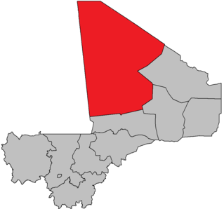
Taoudenni is a remote salt mining center in the desert region of northern Mali, 664 km (413 mi) north of Timbuktu. It is the capital of Taoudénit Region. The salt is dug by hand from the bed of an ancient salt lake, cut into slabs, and transported either by truck or by camel to Timbuktu. The camel caravans (azalai) from Taoudenni are some of the last that still operate in the Sahara Desert. In the late 1960s, during the regime of Moussa Traoré, a prison was built at the site and the inmates forced to work in the mines. The prison was closed in 1988.

Kidal is a town and commune in the desert region of northern Mali. The town lies 285 km (177 mi) northeast of Gao and is the capital of the Kidal Cercle and the Kidal Region. The commune has an area of about 9,910 km2 (3,830 sq mi) and includes the town of Kidal and 31 other settlements.

Kidal Region is the eighth administrative region of Mali, covering 151,450 square kilometres or 58,480 square miles. This area was formerly part of Gao Region, but was created as a separate region in 1991. It is located in the north of the country, within the territory which the National Movement for the Liberation of Azawad proclaimed to be the independent nation-state of Azawad on 6 April 2012. This independence has not been recognized by any country or international organization. It was under the control of different armed movements such as the Ansar Dine and MNLA until January 2013, when French forces liberated the region. The Region's administrative capital is the town of Kidal.

The Insurgency in the Maghreb refers to Islamist militant and terrorist activity in the Maghreb and Sahel regions of North Africa since 2002. The conflict succeeded the conclusion of the Algerian Civil War as the militant group Salafist Group for Preaching and Combat (GSPC) allied itself with al-Qaeda to eventually become al-Qaeda in the Islamic Maghreb (AQIM). Algeria and other Maghreb states affected by the activity have been offered assistance in fighting extremist militants by the United States and the United Kingdom since 2007, when Operation Enduring Freedom – Trans Sahara began.

Bla Cercle is an administrative subdivision of the Ségou Region of Mali. The administrative center (chef-lieu) is the town of Bla.
Dégnékoro is a rural commune and village in the Cercle of Dioila in the Koulikoro Region of southern Mali.
Diouman or Dioumanzana is a village and commune in the Cercle of Dioila in the Koulikoro Region of southern Mali.
Benkadi is a rural commune in the Cercle of Dioïla in the Koulikoro Region of south-western Mali. The main village (chef-lieu) is Kotoula.
Danderesso is a small town and rural commune in the Cercle of Sikasso in the Sikasso Region of southern Mali. The commune covers an area of 1,645 square kilometers and includes the town and 30 villages. In the 2009 census it had a population of 41,723. The town of Danderesso, the chef-lieu of the commune, is 28 km northeast of Sikasso.
Sankarani is a rural commune in the Cercle of Yanfolila in the Sikasso Region of southern Mali. The commune covers an area of 229 square kilometers and includes 8 villages. In the 2009 census it had a population of 7,876. The village of Bambala, the administrative center (chef-lieu) of the commune, is 30 km northwest of Yanfolila on the western shore of Lake Sélingué.

Ménaka is a region of Mali legislatively created in 2012 from the cercle of the same name previously part of Gao Region. Actual implementation of the region began on 19 January 2016 with the appointment of Daouda Maïga as the region's governor. Members of the region's transitional council were appointed on 14 October 2016. The region is divided into four cercles: Andéramboukane, Inékar, Tidermène, and Ménaka, the location of the capital, also called Ménaka.
Achouratt is a cercle of Taoudénit Region, Mali.
Al-Ourche is a cercle of Taoudénit Region, Mali.
Boudje-Béha is a cercle of Taoudénit Region, Mali.
Foum-Alba is a cercle of Taoudénit Region, Mali.
Taoudénit is a cercle of Taoudénit Region, Mali.