Banamba Cercle

Last updated
Banamba
Cercle of Banamba.png
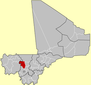
Location of Banamba Cercle in Mali
CountryFlag of Mali.svg  Mali
Region Koulikoro Region
Admin HQ ( Chef-lieu ) Banamba
Area
[1]
  Total7,500 km2 (2,900 sq mi)
Population
 (2009 census) [2]
  Total190,235
  Density25/km2 (66/sq mi)
Time zone UTC+0 (GMT)

Banamba Cercle is an administrative subdivision of the Koulikoro Region of Mali. Its seat is the town of Banamba, which is also its largest settlement. It lies at the center east of the region.

Koulikoro Region Region in Mali

Koulikoro Region is a region in western Mali. It is the second administrative area of Mali and covers an area of 90,120 km2. Its capital is the city of Koulikoro.

Mali Republic in West Africa

Mali, officially the Republic of Mali, is a landlocked country in West Africa. Mali is the eighth-largest country in Africa, with an area of just over 1,240,000 square kilometres (480,000 sq mi). The population of Mali is 18 million. 67% of its population was estimated to be under the age of 25 in 2017. Its capital is Bamako. The sovereign state of Mali consists of eight regions and its borders on the north reach deep into the middle of the Sahara Desert, while the country's southern part, where the majority of inhabitants live, features the Niger and Senegal rivers. The country's economy centers on agriculture and mining. Some of Mali's prominent natural resources include gold, being the third largest producer of gold in the African continent, and salt.

Banamba Place in Koulikoro Region, Mali

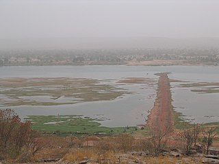
Banamba is the capital of Banamba Cercle, one of the seven Cercles of the Koulikoro Region of Mali. Its estimated 2008 population is 7000. The town lies due north of the regional capital of Koulikoro, and is connected by a 40 km all-weather road via the town of Sirakorola, about halfway between the two. It is the location of the Lycée Franco-Arabe de Banamba.

Banamba Cercle is home to primarily Bambara farmers, and formed part of the pre-colonial Bambara Empire. The Cercle falls largely in the dryer Sahel region, especially in its north, where the population is mostly Fula and Maure pastoralists.

Bambara people ethnic group

The Bambara are a Mandé ethnic group native to much of West Africa, primarily southern Mali, Guinea, Burkina Faso and Senegal. Today they make up the largest Mandé ethnic group in Mali, with 80% of the population speaking the Bambara language, regardless of ethnicity.

Sahel Ecoclimatic and biogeographic transition zone in Africa

The Sahel is the ecoclimatic and biogeographic zone of transition in Africa between the Sahara to the north and the Sudanian Savanna to the south. Having a semi-arid climate, it stretches across the south-central latitudes of Northern Africa between the Atlantic Ocean and the Red Sea. The name is derived from the Arabic word sāḥil meaning "coast" or "shore" in a figurative sense, while the name in Swahili means "coastal [dweller]" in a literal sense. However, this figurative use is unattested in Classical Arabic. The word might have been derived from the Arabic word sahl.

Fula people A large ethnic group in Sahel and West Africa

The Fula,Fulani or Fulɓe people are one of the largest ethnic groups in the Sahel and West Africa, widely dispersed across the region. Inhabiting many countries, they live mainly in West Africa and northern parts of Central Africa but also in South Sudan, Sudan, and regions near the Red Sea coast. There are an estimated 40 million people of Fulani descent in West Africa in total.

The Banamba Cercle is divided into nine rural communes: [3]

Communes of Mali

A Commune is the third level administrative unit in Mali. Mali is divided into eight regions and one capital district (Bamako). These subdivisions bear the name of their principal city. The regions are divided into 49 Cercles. The Cercles and the district are divided into 703 Communes, with 36 Urban Communes and 667 Rural Communes, while some larger Cercles still contain Arrondissements above the Commune level, these are organisational areas with no independent power or office. Rural Communes are subdivided in Villages, while Urban Communes are subdivided into Quartier. Communes usually bear the name of their principal town. The capital, Bamako, consists of six Urban Communes. There were initially 701 communes until the Law No. 01-043 of 7 June 2001 created two new Rural Communes in the desert region in the north east of the country: Alata, Ménaka Cercle in the Gao Region and Intadjedite, Tin-Essako Cercle in the Kidal Region.

Ben Kadi Commune in Koulikoro Region, Mali

Ben Kadi is a commune in the Cercle of Banamba in the Koulikoro Region of south-western Mali. The principal town lies at Samakele. In 1998 the commune had a population of 7606.

Boron, Mali Commune and town in Koulikoro Region, Mali

Boron is a town and commune in the Cercle of Banamba in the Koulikoro Region of south-western Mali. As of 1998 the commune had a population of 32,250.

Duguwolowula Commune in Koulikoro Region, Mali

Duguwolowula is a commune in the Cercle of Banamba in the Koulikoro Region of south-western Mali. The principal town lies at Touba. As of 1998 the commune had a population of 26,374.

Related Research Articles

Nara Cercle Cercle in Koulikoro Region, Mali

Nara Cercle is an administrative subdivision of the Koulikoro Region of Mali. Its seat is the town of Nara.

Koulikoro Cercle Cercle in Koulikoro Region, Mali

Koulikoro Cercle is an administrative subdivision of the Koulikoro Region of Mali. Its seat is the town of Koulikoro, which is also the capital of the region. A major trade and industrial town on the Niger River, Koulikoro has been surpassed by Kati to the west as the largest town in the region. Also to the southwest, lying entirely within Kati Cercle but administratively separate, is the District of Bamako, which after independence was carved out of the middle of the region.

Kolokani Cercle Cercle in Koulikoro Region, Mali

Kolokani Cercle is an administrative subdivision of the Koulikoro Region of Mali. Its seat is the town of Kolokani, which is also its largest settlement. It lies directly to the north of Kati Cercle. Also to the south, is the District of Bamako, which after independence was carved out of the middle of the Region. The cercle is further divided into communes.

Dioïla Cercle Cercle in Koulikoro Region, Mali

Dioïla Cercle is an administrative subdivision of the Koulikoro Region of Mali. Its seat is the town of Dioïla. It lies at the southeast corner of the region, and prior to 1977, it was combined with what is now Kati Cercle and the District of Bamako in the "Bamako Cercle", with the capital city as its seat.

Yorosso Cercle Cercle in Sikasso Region, Mali

Yorosso Cercle is an administrative subdivision of the Sikasso Region of southern Mali. The main town (chef-lieu) is Yorosso.

Gourma-Rharous Cercle Cercle in Tombouctou Region, Mali

Gourma-Rharous Cercle is an administrative subdivision of the Tombouctou Region of Mali. The administrative center is the town of Gourma-Rharous.

Toubakoro Commune in Koulikoro Region, Mali

Toubakoro or Toubacoro is a rural commune in the Cercle of Banamba in the Koulikoro Region of south-western Mali. The commune contains 21 villages.

Degnekoro Commune and village in Koulikoro Region, Mali

Dégnékoro is a rural commune and village in the Cercle of Dioila in the Koulikoro Region of southern Mali.

Diouman Commune and village in Koulikoro Region, Mali

Diouman or Dioumanzana is a village and commune in the Cercle of Dioila in the Koulikoro Region of southern Mali.

Guéniébé Commune and village in Koulikoro Region, Mali

Guéniébé is a village and rural commune in the Cercle of Nara in the Koulikoro Region of south-western Mali. The village is 25 km northeast of Nara, the administrative centre of the cercle.

Guiré Commune and town in Koulikoro Region, Mali

Guiré is a small town and rural commune in the Cercle of Nara in the Koulikoro Region of south-western Mali. The commune covers an area of 6,892 square kilometers and extends to the Mauritanian border. It contains 25 villages and had a population of 19,879 in the 2009 census. The town of Guiré is 90 km southeast of Nara, the administrative centre (chef-lieu) of the cercle.

Koronga Commune and village in Koulikoro Region, Mali

Koronga is a village and commune in the Cercle of Nara in the Koulikoro Region of south-western Mali. The village is 40 km northwest of Nara, the administrative centre of the cercle, and 20 km south of the Mauritanian border. The commune contains 17 villages and in the 2009 census had a population of 7,931.

Banko, Mali Commune and village in Koulikoro Region, Mali

Banko is a rural commune and village in the Cercle of Dioïla in the Koulikoro Region of south-western Mali. The village lies on the Banifing River. The commune contains 31 villages.

Benkadi, Koulikoro Commune in Koulikoro Region, Mali

Benkadi is a rural commune in the Cercle of Dioïla in the Koulikoro Region of south-western Mali. The main village (chef-lieu) is Kotoula.

Binko, Koulikoro Commune in Koulikoro Region, Mali

Binko is a commune in the Cercle of Dioïla in the Koulikoro Region of south-western Mali. The main village (chef-lieu) is Tingolé.

Diédougou, Dioïla Commune in Koulikoro Region, Mali

Diédougou is a rural commune in the Cercle of Dioïla in the Koulikoro Region of south-western Mali. The commune contains 34 villages. The administrative center (chef-lieu) is at the village of Béléko Soba which lies 205 km east of Bamako. In the 2009 census the commune had a population of 39,021.

Niamana, Koulikoro Commune in Koulikoro Region, Mali

Niamana is a rural commune in the Cercle of Nara in the Koulikoro Region of south-western Mali. The commune has an area of 4,985 km2 and contains 39 villages. In the 2009 census the commune had a population of 28,166. The administrative centre is the village of Mourdiah.

Ouagadou Commune in Koulikoro Region, Mali

Ouagadou is a commune in the Cercle of Nara in the Koulikoro Region of south-western Mali. The commune contains the town of Goumbou which is the administrative centre and 6 villages. In the 2009 census the commune had a population of 19,123. Goumbou is 28 km southwest of Nara, the administrative centre (chef-lieu) of the cercle.

Toukoroba Commune and village in Koulikoro Region, Mali

Toukoroba is a rural commune and village in the Cercle of Banamba in the Koulikoro Region of south-western Mali. The commune contains 17 villages.

References

  1. Synthèsis des Plans de Securité Alimentaire des Communes du Cercle Banamba 2008-2012 (PDF) (in French), Commissariat à la Sécurité Alimentaire, République du Mali, USAID-Mali, 2008, archived from the original (PDF) on 2011-07-26, retrieved 2011-02-02.
  2. Resultats Provisoires RGPH 2009 (Région de Koulikoro) (PDF) (in French), République de Mali: Institut National de la Statistique, archived from the original (PDF) on 2011-07-22.
  3. Communes de la Région de Koulokoro (PDF) (in French), Ministère de l’administration territoriale et des collectivités locales, République du Mali, archived from the original (PDF) on 2012-03-09.

Coordinates: 13°45′N7°20′W / 13.750°N 7.333°W / 13.750; -7.333

Geographic coordinate system Coordinate system

A geographic coordinate system is a coordinate system that enables every location on Earth to be specified by a set of numbers, letters or symbols. The coordinates are often chosen such that one of the numbers represents a vertical position and two or three of the numbers represent a horizontal position; alternatively, a geographic position may be expressed in a combined three-dimensional Cartesian vector. A common choice of coordinates is latitude, longitude and elevation. To specify a location on a plane requires a map projection.