Baguinéda-Camp is a small town and rural commune in the Cercle of Kati in the Koulikoro Region of southern Mali. The commune contains 32 villages and in the 2009 census had a population of 58,661. The town lies to the south of the Niger River.
Nyamina is a small town and rural commune in the Cercle of Koulikoro in the Koulikoro Region of south-western Mali. The commune lies to the north of the Niger River and covers an area of 1,283 km2. It includes the town of Nyamina and 47 villages. In the 2009 census the commune had a population of 35,548. The town lies on the left bank of the river, 80 km northeast of Koulikoro.
Bancoumana or Bankoumana is a small town and rural commune in the Cercle of Kati in the Koulikoro Region of south-western Mali. The commune includes the town and 13 villages. At the time of the 2009 census it had a population of 21,714. The town of Bancoumana lies on the left bank of the River Niger 60 km southwest of Bamako, the Malian capital.
Bougoula is a village and rural commune in the Cercle of Kati in the Koulikoro Region of south-western Mali. The commune contains 11 villages and at the time of the 2009 census had a population of 10,780. The village of Bougoula is 50 km south of the Malian capital, Bamako.
Daban is a village and rural commune in the Cercle of Kati in the Koulikoro Region of south-western Mali. The commune is the most northerly of the cercle. It contains 11 villages in an area of 737 square kilometers and at the time of 2009 census had a population of 9,435. The village of Daban is 80 km northwest of Kati, the chef-lieu of the cercle.
Dio-Gare is a village and rural commune in the Cercle of Kati in the Koulikoro Region of south-western Mali. The commune has an area of 180 km2 and contains 7 villages. At the time of the 2009 census the commune had a population of 8,161. The main village, Dio-Gare, is 20 km northwest of Kati, the chef-lieu of the cercle. The Dakar–Niger Railway passes through the village.
Faraba is a village and rural commune in the Cercle of Kati in the Koulikoro Region of south-western Mali. The commune contains 6 villages and in the 2009 census had a population of 9,577.
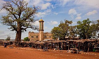
Kalifabougou is a small town and rural commune in the Cercle of Kati in the Koulikoro Region of south-western Mali. The commune includes 12 villages and covers an area of 241 km2. In the 2009 census the population of the commune was 4,796. The village of Kalifabougou is 30 km northwest of Kati, the chef-lieu of the cercle.
Kambila is a village and rural commune in the Cercle of Kati in the Koulikoro Region of south-western Mali. The commune has an area of 429 km2 and contains 15 villages. In the 2009 census the commune had a population of 13,974. The village of Kambila lies just to the east of the Route Nationale 1 (RN1) and 9 km north of Kati, the chef-lieu of the cercle.
Kourouba is a village and rural commune in the Cercle of Kati in the Koulikoro Region of south-western Mali. The commune covers an area of 245 km2 and includes 5 villages. In the 2009 census the commune had a population of 8,248. The village of Kourouba is on the right bank of the Sankarani River just upstream of where it joins the Niger River.
N'Gouraba is a village and rural commune in the Cercle of Kati in the Koulikoro Region of south-western Mali. The commune covers an area of 579 square kilometers and includes 13 villages. In the 2009 census the commune had a population of 15,474. The village of N'Gouraba is 75 km southeast of the Malian capital, Bamako.
Doubabougou is a village and rural commune in the Cercle of Kati in the Koulikoro Region of south-western Mali. The commune contains 6 villages and had a population of 5,041 at the time of the 2009 census.
Mountougoula is a village and rural commune in the Cercle of Kati in the Koulikoro Region of south-western Mali. The commune covers an area of 369 square kilometers and includes 16 villages. In the 2009 census the commune had a population of 11,814. The village of Mountougoula lies 30 km southeast of Bamako, the Malian capital.
N'Gabacoro or N'Gabacoro-Droit is a small town and rural commune in the Cercle of Kati in the Koulikoro Region of south-western Mali. The commune covers an area of 103 square kilometers and includes the town and 6 villages. In the 2009 census the commune had a population of 15,153. The town of N'Gabacoro lies 18 km east of the Malian capital, Bamako.
Fallou is a village and rural commune in the Cercle of Nara in the Koulikoro Region of south-western Mali. The commune contains 43 villages and in the 2009 census had a population of 30,239.
Guiré is a small town and rural commune in the Cercle of Nara in the Koulikoro Region of south-western Mali. The commune covers an area of 6,892 square kilometers and extends to the Mauritanian border. It contains 25 villages and had a population of 19,879 in the 2009 census. The town of Guiré is 90 km southeast of Nara, the administrative centre (chef-lieu) of the cercle.
Diédougou is a rural commune in the Cercle of Dioïla in the Koulikoro Region of south-western Mali. The commune contains 34 villages. The administrative center (chef-lieu) is at the village of Béléko Soba which lies 205 km east of Bamako. In the 2009 census the commune had a population of 39,021.
Bossofala is a rural commune in the Cercle of Kati in the Koulikoro Region of south-western Mali. The commune contains the main town, Neguela, and 16 villages. At the time of the 2009 census the commune had a population of 17,455. The commune lies to the northwest of Bamako, the Malian capital, and is bounded to the west by the River Baoulé, a tributary of Bakoy.
Dabo is a rural commune in the Cercle of Nara in the Koulikoro Region of south-western Mali. The commune contains 10 villages and had a population of 11,855 in the 2009 census. The main village is Boulal.
Niamana is a rural commune in the Cercle of Nara in the Koulikoro Region of south-western Mali. The commune has an area of 4,985 km2 and contains 39 villages. In the 2009 census the commune had a population of 28,166. The administrative centre is the village of Mourdiah.

