Diéma Cercle is an administrative subdivision of the Kayes Region of Mali. Its administrative center (chef-lieu) is the small town of Diéma. The Cercle is divided into one urban commune and fourteen rural communes. In the 2009 census the cercle had a population of 212,062.

Kayes Cercle is an administrative subdivision of the Kayes Region of Mali. Its seat is the city of Kayes, which is also the capital of its Region and its largest city. The Cercle is further divided into Communes. The city of Kayes is subdivided into Urban Communes and Wards. Kayes Cercle's population in 2009 was 513,362.

Nara Cercle is an administrative subdivision of the Koulikoro Region of Mali. Its seat is the town of Nara.
Sandare is a small town and commune in the Cercle of Nioro du Sahel in the Kayes Region of south-western Mali. In 1998 the commune had a population of 18328.
Simbi, Mali is a small town and commune in the Cercle of Nioro du Sahel in the Kayes Region of south-western Mali. In 1998 the commune had a population of 15658.

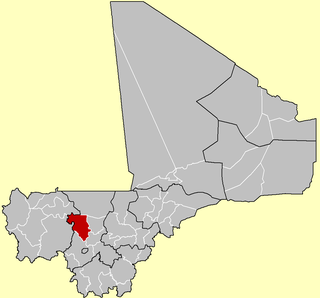
Bougouni Cercle is an administrative subdivision of the Sikasso Region of Mali. The administrative center (chef-lieu) is the town of Bougouni.

Niono Cercle is an administrative subdivision of the Ségou Region of Mali. The administrative center (chef-lieu) is the town of Niono.

Bandiagara Cercle is an administrative subdivision of the Mopti Region of Mali. The administrative center (chef-lieu) is the town of Bandiagara.

Koro Cercle is an administrative subdivision of the Mopti Region of Mali. The administrative center is the town of Koro.

Mopti Cercle is an administrative subdivision of the Mopti Region of Mali. The administrative center (chef-lieu) is the town of Mopti.
Bladié-Tiémala is a rural commune and village in the Cercle of Bougouni in the Sikasso Region of southern Mali.
Kokele is a small town and commune in the Cercle of Bougouni in the Sikasso Region of southern Mali. In 1998 the commune had a population of 5,753.
Sibirila is a commune in the Cercle of Bougouni in the Sikasso Region of southern Mali. The principal town lies at Manankoro. In 1998 the commune had a population of 14,012.
Kouroulamini is a commune in the Cercle of Bougouni in the Sikasso Region of southern Mali. The principal town lies at N'Tentou. In 1998 the commune had a population of 3,128.

Dogofry is a village and a rural commune in the Cercle of Niona in the Ségou Region of southern-central Mali. The commune covers an area of approximately 3,820 square kilometers and is bordered to the north by the Republic of Mauritania, to the east by the commune of Nampalari, to the southeast by the commune of Diabaly, to the southwest by the commune of Sokolo and to the west by the commune of Guiré in the Cercle of Nara. It includes 19 villages, and had a population of 34,057 in the 2009 census. The south of the commune includes a region irrigated as part of the Office du Niger scheme. The village of Dogofry lies in this irrigated area, about 60 km north of Niono, to the west of the Fala de Molodo and the Distributeur de Kogoni.
N'Goa is a small town and commune in the Cercle of San in the Ségou Region of Mali. As of 1998 the commune had a population of 7,172.
Bondo is a village and commune and seat of the Cercle of Koro in the Mopti Region of Mali. In 1998 the commune had a population of 15,872 In 2009, population was almost 20,000.
Diankabou is a village and commune and seat of the Cercle of Koro in the Mopti Region of Mali. In 1998 the commune had a population of 14,760.
Kassa is a commune of the Cercle of Koro in the Mopti Region of Mali. The principal village lies at Berdosso. In 1998 the commune had a population of 11,218.
Bambara Maoudé or Bambara Maoundé is a village and rural commune of the Cercle of Gourma-Rharous in the Tombouctou Region of Mali. The commune contains 44 villages and had a population of 16,874 in the 2009 census.