Niantjila | |
|---|---|
Commune and town | |
| Country | |
| Region | Koulikoro Region |
| Cercle | Dioila Cercle |
| Population (1998) | |
| • Total | 12,845 |
| Time zone | UTC+0 (GMT) |
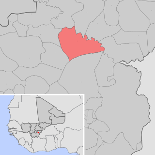
Niantjila is a small town and commune in the Cercle of Dioila in the Koulikoro Region of southern Mali.
Niantjila | |
|---|---|
Commune and town | |
| Country | |
| Region | Koulikoro Region |
| Cercle | Dioila Cercle |
| Population (1998) | |
| • Total | 12,845 |
| Time zone | UTC+0 (GMT) |
Niantjila is a small town and commune in the Cercle of Dioila in the Koulikoro Region of southern Mali.
As of 1998 the commune had a population of 12,845. [1]

Kayes Cercle is an administrative subdivision of the Kayes Region of Mali. Its seat is the city of Kayes, which is also the capital of its Region and its largest city. The Cercle is further divided into Communes. The city of Kayes is subdivided into Urban Communes and Wards. Kayes Cercle's population in 2009 was 513,362.

Dioïla Cercle is an administrative subdivision of the Koulikoro Region of Mali. Its seat is the town of Dioïla. It lies at the southeast corner of the region, and prior to 1977, it was combined with what is now Kati Cercle and the District of Bamako in the "Bamako Cercle", with the capital city as its seat.

Bougouni Cercle is an administrative subdivision of the Sikasso Region of Mali. The administrative center (chef-lieu) is the town of Bougouni.

Kolondiéba Cercle is an administrative subdivision of the Sikasso Region of Mali. The administrative center (chef-lieu) is the town of Kolondiéba.

Sikasso Cercle is one of seven administrative subdivision of the Sikasso Region of southern Mali. The capital is the town of Sikasso.

Barouéli Cercle is an administrative subdivision of the Ségou Region of Mali. The administrative center (chef-lieu) is the town of Barouéli.

Macina Cercle is an administrative subdivision of the Ségou Region of Mali. The administrative center (chef-lieu) is the town of Macina.

Niono Cercle is an administrative subdivision of the Ségou Region of Mali. The administrative center (chef-lieu) is the town of Niono.

Tominian Cercle is an administrative subdivision of the Ségou Region of Mali. The administrative center of the local government is in the town of Tominian. The Cercle is divided into Communes, and below this, quarters/villages. In the 2009 census the cercle had a population of 219,853 people.

Gourma-Rharous Cercle is an administrative subdivision of the Tombouctou Region of Mali. The administrative center is the town of Gourma-Rharous.
Defina is a small town and commune in the Cercle of Bougouni in the Sikasso Region of southern Mali. In 1998 the commune had a population of 6,109.
Bladié-Tiémala is a rural commune and village in the Cercle of Bougouni in the Sikasso Region of southern Mali.
Wola is a small town and commune in the Cercle of Bougouni in the Sikasso Region of south-western Mali. In 1998 the commune had a population of 10,158.
Debelin is a small town and commune in the Cercle of Bougouni in the Sikasso Region of south-western Mali. In 1998 the commune had a population of 4,990.
Faragouaran is a small town and commune in the Cercle of Bougouni in the Sikasso Region of southern Mali. In 1998 the commune had a population of 6,971.
Farako is a small town and commune in the Cercle of Kolondieba in the Sikasso Region of southern Mali. In 1998 the commune had a population of 9,769.
Tousseguela is a small town and commune in the Cercle of Kolondieba in the Sikasso Region of southern Mali. In 1998 the commune had a population of 4894.
Mena is a small town and commune in the Cercle of Kolondieba in the Sikasso Region of southern Mali. In 1998 the commune had a population of 5014.
Kouoro is a small town and rural commune in the Cercle of Sikasso in the Sikasso Region of southern Mali. The commune covers an area of 472 square kilometers and includes the town and five villages. In the 2009 census it had a population of 11,315. The town of Kouoro, the chef-lieu of the commune, is 75 km north of Sikasso, on the RN11, the main road linking Sikasso and Koutiala. It is also about 30 km west of the border with Burkina Faso.

Dogofry is a village and a rural commune in the Cercle of Niona in the Ségou Region of southern-central Mali. The commune covers an area of approximately 3,820 square kilometers and is bordered to the north by the Republic of Mauritania, to the east by the commune of Nampalari, to the southeast by the commune of Diabaly, to the southwest by the commune of Sokolo and to the west by the commune of Guiré in the Cercle of Nara. It includes 19 villages, and had a population of 34,057 in the 2009 census. The south of the commune includes a region irrigated as part of the Office du Niger scheme. The village of Dogofry lies in this irrigated area, about 60 km north of Niono, to the west of the Fala de Molodo and the Distributeur de Kogoni.
Coordinates: 11°47′51″N6°32′41″W / 11.79750°N 6.54472°W
| This Koulikoro Region location article is a stub. You can help Wikipedia by expanding it. |
