Nara Cercle is an administrative subdivision of the Koulikoro Region of Mali. Its seat is the town of Nara.
Kolokani Cercle is an administrative subdivision of the Koulikoro Region of Mali. Its seat is the town of Kolokani, which is also its largest settlement. It lies directly to the north of Kati Cercle. Also to the south, is the District of Bamako, which after independence was carved out of the middle of the Region. The cercle is further divided into communes.

Dioïla Cercle is an administrative subdivision of the Koulikoro Region of Mali. Its seat is the town of Dioïla. It lies at the southeast corner of the region, and prior to 1977, it was combined with what is now Kati Cercle and the District of Bamako in the "Bamako Cercle", with the capital city as its seat.

Banamba Cercle is an administrative subdivision of the Koulikoro Region of Mali. Its seat is the town of Banamba, which is also its largest settlement. It lies at the center east of the region.

The Kangaba Cercle is an administrative subdivision of the Koulikoro Region of Mali. Its seat is the town and commune of Benkadi Habaladougou (Kenieba), also known as Kangaba. It lies at the southwest corner of the region, along the Guinean border, with the Niger River forming its southern edge.
N'Golobougou is a small town and commune in the Cercle of Dioila in the Koulikoro Region of southern Mali. As of 1998 the commune had a population of 14,880.
Jèkafo is a small town and commune in the Cercle of Dioila in the Koulikoro Region of southern Mali. As of 1998 the commune had a population of 5,138.
Kaniogo is a small town and commune in the Cercle of Kangaba in the Koulikoro Region of south-western Mali. As of 1998 the commune had a population of 11415.

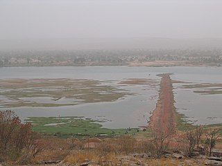
Nyamina is a small town and rural commune in the Cercle of Koulikoro in the Koulikoro Region of south-western Mali. The commune lies to the north of the Niger River and covers an area of 1,283 km2. It includes the town of Nyamina and 47 villages. In the 2009 census the commune had a population of 35,548. The town lies on the left bank of the river, 80 km northeast of Koulikoro.
Nonkon is a small town and commune in the Cercle of Kolokani in the Koulikoro Region of south-western Mali. As of 1998 the commune had a population of 15,253. The economy is based on agriculture.
Sagabala is a small town and commune in the Cercle of Kolokani in the Koulikoro Region of south-western Mali. As of 1998 the commune had a population of 15,464.
Bougoula is a village and rural commune in the Cercle of Kati in the Koulikoro Region of south-western Mali. The commune contains 11 villages and at the time of the 2009 census had a population of 10,780. The village of Bougoula is 50 km south of the Malian capital, Bamako.
Dialakoroba is a village and rural commune in the Cercle of Kati in the Koulikoro Region of south-western Mali. The commune contains 24 villages and in the 2009 census had a population of 22,907. The village of Dialakoroba lies on the Route Nationale 7 (RN7) 50 km south of Bamako, the Malian capital.
N'Gouraba is a village and rural commune in the Cercle of Kati in the Koulikoro Region of south-western Mali. The commune covers an area of 579 square kilometers and includes 13 villages. In the 2009 census the commune had a population of 15,474. The village of N'Gouraba is 75 km southeast of the Malian capital, Bamako.
N'Tjiba is a rural commune in the Cercle of Kati in the Koulikoro Region of south-western Mali. The commune covers an area of approximately 802 square kilometers and includes 18 villages. The administrative centre is the village of Faladié. In the 2009 census the commune had a population of 23,617.

Ouélessébougou is a town and rural commune in the Cercle of Kati in the Koulikoro Region of south-western Mali. The commune covers an area of approximately 1,118 square kilometers and includes the town of Ouélessébougou and 44 villages. In the 2009 census the commune had a population of 50,056. The town lies 80 km south of Bamako on the Route Nationale 7.
Zan Coulibaly is a commune in the Cercle of Dioïla in the Koulikoro Region of south-western Mali. The principal town lies at Marka Coungo. In 1998 the commune had a population of 10037.The commune is known for its cotton industry.
Dinandougou is a commune in the Cercle of Koulikoro in the Koulikoro Region of south-western Mali. The principal town lies at Kenekou and it has 28 villages: Banancoro, Bakolé, Bougoukoro, Bouramabougou, Dinan-Marka, Dinan-Bamanan, Diaguinébougou, Diecoungo, Dioni, Doubala, Donéguébougou, Fatiambougou, Gossigo, Goundando, Kakoulé, Kaliabougou, Kamani, Kassa, Mamadibougou, Ourongo, Sassila, Sirimou, Tamato, Tiécourabougou-Est, Tiécorurabougou-Ouest, Tieconungo, Tidiani-Tourébougou, and Tierkéla. As of 2005 the commune had a population of 17841.
Sanankoro Djitoumou is a village and rural commune in the Cercle of Kati in the Koulikoro Region of southern Mali. The commune covers an area of approximately 630 square kilometers and includes 27 villages. In the 2009 census it had a population of 13,382. The village lies 75 km south of the Malian capital, Bamako.