
Kéniéba is a rural commune, small town and seat of Kéniéba Cercle in Mali's Kayes Region. As well as the main town, the commune includes 26 other villages. In the 2009 census the commune had a population of 39,557.
Nara is a town and rural commune in the Koulikoro Region of southwestern Mali. The town is the administrative center of the Nara Cercle. It is 37 km south of the Mauritanian border and 292 km north-northeast of the Malian capital, Bamako. The rural commune covers an area of 1300 square kilometers and includes the town and 16 surrounding villages. In the 2009 census the commune had a population of 19,793.

Nara Cercle is an administrative subdivision of the Koulikoro Region of Mali. Its seat is the town of Nara.
Koulikoro Cercle is an administrative subdivision of the Koulikoro Region of Mali. Its seat is the town of Koulikoro, which is also the capital of the region. A major trade and industrial town on the Niger River, Koulikoro has been surpassed by Kati to the west as the largest town in the region. Also to the southwest, lying entirely within Kati Cercle but administratively separate, is the District of Bamako, which after independence was carved out of the middle of the region.

Dioïla Cercle is an administrative subdivision of the Koulikoro Region of Mali. Its seat is the town of Dioïla. It lies at the southeast corner of the region, and prior to 1977, it was combined with what is now Kati Cercle and the District of Bamako in the "Bamako Cercle", with the capital city as its seat.
Baguinéda-Camp is a small town and rural commune in the Cercle of Kati in the Koulikoro Region of southern Mali. The commune contains 32 villages and in the 2009 census had a population of 58,661. The town lies to the south of the Niger River.
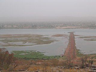
Nyamina is a small town and rural commune in the Cercle of Koulikoro in the Koulikoro Region of south-western Mali. The commune lies to the north of the Niger River and covers an area of 1,283 km2. It includes the town of Nyamina and 47 villages. In the 2009 census the commune had a population of 35,548. The town lies on the left bank of the river, 80 km northeast of Koulikoro.
Bancoumana or Bankoumana is a small town and rural commune in the Cercle of Kati in the Koulikoro Region of south-western Mali. The commune includes the town and 13 villages. At the time of the 2009 census it had a population of 21,714. The town of Bancoumana lies on the left bank of the River Niger 60 km southwest of Bamako, the Malian capital.
Dogodouman is a small town and commune in the Cercle of Kati in the Koulikoro Region of south-western Mali. The small commune is classified as rural commune but lies close to the western suburbs of Bamako, the Malian capital, at the edge of the Monts Mandigues. In the 2009 census the commune had a population of 8,851.
Kalifabougou is a small town and rural commune in the Cercle of Kati in the Koulikoro Region of south-western Mali. The commune includes 12 villages and covers an area of 241 km2. In the 2009 census the population of the commune was 4,796. The village of Kalifabougou is 30 km northwest of Kati, the chef-lieu of the cercle.

Ouélessébougou is a town and rural commune in the Cercle of Kati in the Koulikoro Region of south-western Mali. The commune covers an area of approximately 1,118 square kilometers and includes the town of Ouélessébougou and 44 villages. In the 2009 census the commune had a population of 50,056. The town lies 80 km south of Bamako on the Route Nationale 7.
Diago is a village and rural commune in the Cercle of Kati in the Koulikoro Region of south-western Mali. The commune contains 7 villages and in the 2009 census had a population of 3,269. The village of Diago is 10 km northwest the town of Kati, the chef-lieu of the cercle.
Yélékébougou is a village and rural commune in the Cercle of Kati in the Koulikoro Region of south-western Mali. The commune has an area of approximately 288 square kilometers and includes 16 villages. In the 2009 census the commune had a population of 7,257. The village of Yélékébougou is 30 km north of the town of Kati, the chef-lieu of the cercle.
Allahina is a small town and rural commune in the Cercle of Nara in the Koulikoro Region of south-western Mali. The town lies 31 km south of the Mauritanian border and 156 km west of Nara, the administrative centre of the cercle. The commune, which includes the town and seven of the surrounding villages, had a population of 11,683 in the 2009 census.
Guiré is a small town and rural commune in the Cercle of Nara in the Koulikoro Region of south-western Mali. The commune covers an area of 6,892 square kilometers and extends to the Mauritanian border. It contains 25 villages and had a population of 19,879 in the 2009 census. The town of Guiré is 90 km southeast of Nara, the administrative centre (chef-lieu) of the cercle.
Ouagadou is a commune in the Cercle of Nara in the Koulikoro Region of south-western Mali. The commune contains the town of Goumbou which is the administrative centre and 6 villages. In the 2009 census the commune had a population of 19,123. Goumbou is 28 km southwest of Nara, the administrative centre (chef-lieu) of the cercle.
Sanankoroba is a small town and rural commune in the Cercle of Kati in the Koulikoro Region of southern Mali. The commune covers an area of approximately 617 square kilometers and includes the town and 25 villages. In the 2009 census the commune had a population of 37,294. The town lies 34 km south of the Malian capital, Bamako, on the Route Nationale 7 (RN7).


