Dégnékoro is a rural commune and village in the Cercle of Dioila in the Koulikoro Region of southern Mali.
Diouman or Dioumanzana is a village and commune in the Cercle of Dioila in the Koulikoro Region of southern Mali.
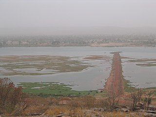
Baguinéda-Camp is a small town and rural commune in the Cercle of Kati in the Koulikoro Region of southern Mali. The commune contains 32 villages and in the 2009 census had a population of 58,661. The town lies to the south of the Niger River.
Nyamina is a small town and rural commune in the Cercle of Koulikoro in the Koulikoro Region of south-western Mali. The commune lies to the north of the Niger River and covers an area of 1,283 km2. It includes the town of Nyamina and 47 villages. In the 2009 census the commune had a population of 35,548. The town lies on the left bank of the river, 80 km northeast of Koulikoro.
Doumba is a small town and commune in the Cercle of Koulikoro in the Koulikoro Region of south-western Mali. It covers a surface of 250 km2 and comprises 7 villages: Doumba, Fani, Babougou, Dombana, Kossaba, Dibaro, and Sinzani. As of 2008 the commune had a population of 7557 inhabitants
Bougoula is a village and rural commune in the Cercle of Kati in the Koulikoro Region of south-western Mali. The commune contains 11 villages and at the time of the 2009 census had a population of 10,780. The village of Bougoula is 50 km south of the Malian capital, Bamako.
Dialakoroba is a village and rural commune in the Cercle of Kati in the Koulikoro Region of south-western Mali. The commune contains 24 villages and in the 2009 census had a population of 22,907. The village of Dialakoroba lies on the Route Nationale 7 (RN7) 50 km south of Bamako, the Malian capital.
Dio-Gare is a village and rural commune in the Cercle of Kati in the Koulikoro Region of south-western Mali. The commune has an area of 180 km2 and contains 7 villages. At the time of the 2009 census the commune had a population of 8,161. The main village, Dio-Gare, is 20 km northwest of Kati, the chef-lieu of the cercle. The Dakar–Niger Railway passes through the village.
Dombila is a village and rural commune in the Cercle of Kati in the Koulikoro Region of south-western Mali. The commune contains 11 villages and in the 2009 census had a population of 3,506.
Kourouba is a village and rural commune in the Cercle of Kati in the Koulikoro Region of south-western Mali. The commune covers an area of 245 km2 and includes 5 villages. In the 2009 census the commune had a population of 8,248. The village of Kourouba is on the right bank of the Sankarani River just upstream of where it joins the Niger River.

Ouélessébougou is a town and rural commune in the Cercle of Kati in the Koulikoro Region of south-western Mali. The commune covers an area of approximately 1,118 square kilometers and includes the town of Ouélessébougou and 44 villages. In the 2009 census the commune had a population of 50,056. The town lies 80 km south of Bamako on the Route Nationale 7.
Doubabougou is a village and rural commune in the Cercle of Kati in the Koulikoro Region of south-western Mali. The commune contains 6 villages and had a population of 5,041 at the time of the 2009 census.
Banko is a rural commune and village in the Cercle of Dioïla in the Koulikoro Region of south-western Mali. The village lies on the Banifing River. The commune contains 31 villages.
Dolendougou is a commune in the Cercle of Dioïla in the Koulikoro Region of south-western Mali. The main village (chef-lieu) is Dandougou.
Benkadi is a rural commune in the Cercle of Dioïla in the Koulikoro Region of south-western Mali. The main village (chef-lieu) is Kotoula.
Binko is a commune in the Cercle of Dioïla in the Koulikoro Region of south-western Mali. The main village (chef-lieu) is Tingolé.
Diédougou is a rural commune in the Cercle of Dioïla in the Koulikoro Region of south-western Mali. The commune contains 34 villages. The administrative center (chef-lieu) is at the village of Béléko Soba which lies 205 km east of Bamako. In the 2009 census the commune had a population of 39,021.
Sanankoro Djitoumou is a village and rural commune in the Cercle of Kati in the Koulikoro Region of southern Mali. The commune covers an area of approximately 630 square kilometers and includes 27 villages. In the 2009 census it had a population of 13,382. The village lies 75 km south of the Malian capital, Bamako.