
Nara is a town and rural commune in the Koulikoro Region of southwestern Mali. The town is the administrative center of the Nara Cercle. It is about 37 kilometres (23 mi), south of the international border with Mauritania and approximately 374 kilometres (232 mi), by road, northeast of the Malian capital, Bamako.
Baguinéda-Camp is a small town and rural commune in the Cercle of Kati in the Koulikoro Region of southern Mali. The commune contains 32 villages and in the 2009 census had a population of 58,661. The town lies to the south of the Niger River.
Nyamina is a small town and rural commune in the Cercle of Koulikoro in the Koulikoro Region of south-western Mali. The commune lies to the north of the Niger River and covers an area of 1,283 km2. It includes the town of Nyamina and 47 villages. In the 2009 census the commune had a population of 35,548. The town lies on the left bank of the river, 80 km northeast of Koulikoro.
Bancoumana or Bankoumana is a small town and rural commune in the Cercle of Kati in the Koulikoro Region of south-western Mali. The commune includes the town and 13 villages. At the time of the 2009 census it had a population of 21,714. The town of Bancoumana lies on the left bank of the River Niger 60 km southwest of Bamako, the Malian capital.
Dialakoroba is a village and rural commune in the Cercle of Kati in the Koulikoro Region of south-western Mali. The commune contains 24 villages and in the 2009 census had a population of 22,907. The village of Dialakoroba lies on the Route Nationale 7 (RN7) 50 km south of Bamako, the Malian capital.
Faraba is a village and rural commune in the Cercle of Kati in the Koulikoro Region of south-western Mali. The commune contains 6 villages and in the 2009 census had a population of 9,577.
Tiakadougou-Dialakoro is a village and rural commune in the Cercle of Kati in the Koulikoro Region of south-western Mali. The commune covers an area of 327 square kilometers and includes 9 villages. In the 2009 census it had a population of 6,738.
Kambila is a village and rural commune in the Cercle of Kati in the Koulikoro Region of south-western Mali. The commune has an area of 429 km2 and contains 15 villages. In the 2009 census the commune had a population of 13,974. The village of Kambila lies just to the east of the Route Nationale 1 (RN1) and 9 km north of Kati, the chef-lieu of the cercle.
Moribabougou is a small town and rural commune in the Cercle of Kati in the Koulikoro Region of south-western Mali. It lies on the eastern outskirts of the greater Bamako area. In the 2009 census the commune had a population of 28,574.
N'Gouraba is a village and rural commune in the Cercle of Kati in the Koulikoro Region of south-western Mali. The commune covers an area of 579 square kilometers and includes 13 villages. In the 2009 census the commune had a population of 15,474. The village of N'Gouraba is 75 km southeast of the Malian capital, Bamako.
N'Tjiba is a rural commune in the Cercle of Kati in the Koulikoro Region of south-western Mali. The commune covers an area of approximately 802 square kilometers and includes 18 villages. The administrative centre is the village of Faladié. In the 2009 census the commune had a population of 23,617.
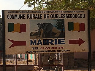
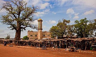
Ouélessébougou is a town and rural commune in the Cercle of Kati in the Koulikoro Region of south-western Mali. The commune covers an area of approximately 1,118 square kilometers and includes the town of Ouélessébougou and 44 villages. In the 2009 census the commune had a population of 50,056. The town lies 80 km south of Bamako on the Route Nationale 7.
Safo is a village and rural commune in the Cercle of Kati in the Koulikoro Region of south-western Mali. The commune has an area of approximately 307 square kilometers and includes 14 villages. In the 2009 census the commune had a population of 16,066. The village of Safo is 20 km northeast of Bamako, the Malian capital.
Nioumamakana or Niouma Makana is a village and rural commune in the Cercle of Kati in the Koulikoro Region of south-western Mali. The commune covers an area of 311 square kilometers and includes 10 villages. In the 2009 census it had a population of 7,442. The administrative centre (chef-lieu) is the village of Nioumamakana.
Niagadina is a village and rural commune in the Cercle of Kati in the Koulikoro Region of south-western Mali. The commune has an area of 87 square kilometers and includes five villages. The administrative center is the village of Niagadina which lies on the right bank of the Niger River, 72 km southwest of Bamako, the Malian capital. In the 2009 census the commune had a population of 11,961.
Yélékébougou is a village and rural commune in the Cercle of Kati in the Koulikoro Region of south-western Mali. The commune has an area of approximately 288 square kilometers and includes 16 villages. In the 2009 census the commune had a population of 7,257. The village of Yélékébougou is 30 km north of the town of Kati, the chef-lieu of the cercle.
Sangarébougou is a suburb of Bamako, the capital of Mali, and a commune in the Cercle of Kati in the Koulikoro Region of south-western Mali. The commune lies to the northeast of Commune I of Bamako and around 10 km from the city center. The commune covers and area of 20 square kilometers and in the 2009 census had a population of 45,518.
N'Gabacoro or N'Gabacoro-Droit is a small town and rural commune in the Cercle of Kati in the Koulikoro Region of south-western Mali. The commune covers an area of 103 square kilometers and includes the town and 6 villages. In the 2009 census the commune had a population of 15,153. The town of N'Gabacoro lies 18 km east of the Malian capital, Bamako.
Guiré is a small town and rural commune in the Cercle of Nara in the Koulikoro Region of south-western Mali. The commune covers an area of 6,892 square kilometers and extends to the Mauritanian border. It contains 25 villages and had a population of 19,879 in the 2009 census. The town of Guiré is 90 km southeast of Nara, the administrative centre (chef-lieu) of the cercle.
Sanankoro Djitoumou is a village and rural commune in the Cercle of Kati in the Koulikoro Region of southern Mali. The commune covers an area of approximately 630 square kilometers and includes 27 villages. In the 2009 census it had a population of 13,382. The village lies 75 km south of the Malian capital, Bamako.

