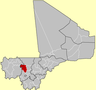
Koulikoro Cercle is an administrative subdivision of the Koulikoro Region of Mali. Its seat is the town of Koulikoro, which is also the capital of the region. A major trade and industrial town on the Niger River, Koulikoro has been surpassed by Kati to the west as the largest town in the region. Also to the southwest, lying entirely within Kati Cercle but administratively separate, is the District of Bamako, which after independence was carved out of the middle of the region.
Kolokani Cercle is an administrative subdivision of the Koulikoro Region of Mali. Its seat is the town of Kolokani, which is also its largest settlement. It lies directly to the north of Kati Cercle. Also to the south, is the District of Bamako, which after independence was carved out of the middle of the Region. The cercle is further divided into communes.
Baguinéda-Camp is a small town and rural commune in the Cercle of Kati in the Koulikoro Region of southern Mali. The commune contains 32 villages and in the 2009 census had a population of 58,661. The town lies to the south of the Niger River.
Bancoumana or Bankoumana is a small town and rural commune in the Cercle of Kati in the Koulikoro Region of south-western Mali. The commune includes the town and 13 villages. At the time of the 2009 census it had a population of 21,714. The town of Bancoumana lies on the left bank of the River Niger 60 km southwest of Bamako, the Malian capital.
Bougoula is a village and rural commune in the Cercle of Kati in the Koulikoro Region of south-western Mali. The commune contains 11 villages and at the time of the 2009 census had a population of 10,780. The village of Bougoula is 50 km south of the Malian capital, Bamako.
Daban is a village and rural commune in the Cercle of Kati in the Koulikoro Region of south-western Mali. The commune is the most northerly of the cercle. It contains 11 villages in an area of 737 square kilometers and at the time of 2009 census had a population of 9,435. The village of Daban is 80 km northwest of Kati, the chef-lieu of the cercle.
Dialakoroba is a village and rural commune in the Cercle of Kati in the Koulikoro Region of south-western Mali. The commune contains 24 villages and in the 2009 census had a population of 22,907. The village of Dialakoroba lies on the Route Nationale 7 (RN7) 50 km south of Bamako, the Malian capital.
Dio-Gare is a village and rural commune in the Cercle of Kati in the Koulikoro Region of south-western Mali. The commune has an area of 180 km2 and contains 7 villages. At the time of the 2009 census the commune had a population of 8,161. The main village, Dio-Gare, is 20 km northwest of Kati, the chef-lieu of the cercle. The Dakar–Niger Railway passes through the village.
Dombila is a village and rural commune in the Cercle of Kati in the Koulikoro Region of south-western Mali. The commune contains 11 villages and in the 2009 census had a population of 3,506.
Faraba is a village and rural commune in the Cercle of Kati in the Koulikoro Region of south-western Mali. The commune contains 6 villages and in the 2009 census had a population of 9,577.
Kalifabougou is a small town and rural commune in the Cercle of Kati in the Koulikoro Region of south-western Mali. The commune includes 12 villages and covers an area of 241 km2. In the 2009 census the population of the commune was 4,796. The village of Kalifabougou is 30 km northwest of Kati, the chef-lieu of the cercle.
Kambila is a village and rural commune in the Cercle of Kati in the Koulikoro Region of south-western Mali. The commune has an area of 429 km2 and contains 15 villages. In the 2009 census the commune had a population of 13,974. The village of Kambila lies just to the east of the Route Nationale 1 (RN1) and 9 km north of Kati, the chef-lieu of the cercle.
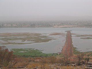
Kourouba is a village and rural commune in the Cercle of Kati in the Koulikoro Region of south-western Mali. The commune covers an area of 245 km2 and includes 5 villages. In the 2009 census the commune had a population of 8,248. The village of Kourouba is on the right bank of the Sankarani River just upstream of where it joins the Niger River.
N'Tjiba is a rural commune in the Cercle of Kati in the Koulikoro Region of south-western Mali. The commune covers an area of approximately 802 square kilometers and includes 18 villages. The administrative centre is the village of Faladié. In the 2009 census the commune had a population of 23,617.
Doubabougou is a village and rural commune in the Cercle of Kati in the Koulikoro Region of south-western Mali. The commune contains 6 villages and had a population of 5,041 at the time of the 2009 census.
Niagadina is a village and rural commune in the Cercle of Kati in the Koulikoro Region of south-western Mali. The commune has an area of 87 square kilometers and includes five villages. The administrative center is the village of Niagadina which lies on the right bank of the Niger River, 72 km southwest of Bamako, the Malian capital. In the 2009 census the commune had a population of 11,961.
Yélékébougou is a village and rural commune in the Cercle of Kati in the Koulikoro Region of south-western Mali. The commune has an area of approximately 288 square kilometers and includes 16 villages. In the 2009 census the commune had a population of 7,257. The village of Yélékébougou is 30 km north of the town of Kati, the chef-lieu of the cercle.
Mandé is a commune in the Cercle of Kati in the Koulikoro Region of south-western Mali. The commune lies to the southwest of Bamako, the Malian capital, along the left bank of the Niger River. It covers for an area of 730 km2 and includes the small town of Ouezzindougou, the administrative centre, and 24 villages. In the 2009 census the commune had a population of 59,352.
Bossofala is a rural commune in the Cercle of Kati in the Koulikoro Region of south-western Mali. The commune contains the main town, Neguela, and 16 villages. At the time of the 2009 census the commune had a population of 17,455. The commune lies to the northwest of Bamako, the Malian capital, and is bounded to the west by the River Baoulé, a tributary of Bakoy.
Diédougou is a rural commune in the Cercle of Kati in the Koulikoro Region of western Mali. The commune includes 16 villages. The main village (chef-lieu) is Torodo. In the 2009 census the commune had a population of 9,381.

