Niéna is a small town and rural commune in the Cercle of Sikasso in the Sikasso Region of southern Mali. The commune covers an area of 1,040 square kilometers and includes the town and 42 villages. In the 2009 census it had a population of 32,265. The town is the administrative center (chef-lieu) of the commune. It is 76 km west of Sikasso on the RN7, the main road linking Sikasso and Bougouni.

Kadiolo Cercle is an administrative subdivision of the Sikasso Region of southern Mali. The administrative center (chef-lieu) is the town of Kadiolo.
Kadiolo is a town, rural commune and seat of the Kadiolo Cercle in the Sikasso Region of southern Mali. The town lies 85 km south of Sikasso, 13 km north of the border with the Ivory Coast and 30 km west of the border with Burkino Faso. The commune of Kadiolo covers an area of 783 square kilometers and includes the town and 19 villages. In the 2009 census it had a population of 59,932.
Dioumaténé is a village and rural commune in the Cercle of Kadiolo in the Sikasso Region of southern Mali. The commune covers an area of 225 square kilometers and includes 5 villages. In the 2009 census it had a population of 4,274. The village of Dioumaténé, the administrative center (chef-lieu) of the commune, is 16 km west of Kadiolo.
Diou is a village and rural commune in the Cercle of Kadiolo in the Sikasso Region of southern Mali. The commune covers an area of 137 square kilometers and includes 3 villages. In the 2009 census it had a population of 6,003. The village of Diou, the administrative center (chef-lieu) of the commune, is 24 km west of Kadiolo.
Kaï is a village and rural commune in the Cercle of Kadiolo in the Sikasso Region of southern Mali. The commune covers an area of 183 square kilometers and includes 8 villages. In the 2009 census it had a population of 8,827. The village of Kaï, the administrative center (chef-lieu) of the commune, is 47 km north of Kadiolo.
Zégoua is a City and commune in the Cercle of Kadiolo in the Sikasso Region of southern Mali. The commune covers an area of 978 square kilometers and includes the town and 8 villages. In the 2017 census it had a population of 230,360. The city of Zégoua, the administrative center (chef-lieu) of the commune, is 2 km north of the border with the Ivory Coast and 14 km southeast of Kadiolo on the RN7, the main road linking Sikasso and Ouangolodougou.
Nimbougou is a village and rural commune in the Cercle of Kadiolo in the Sikasso Region of southern Mali. The commune covers an area of 238 square kilometers and includes 5 villages. In the 2009 census it had a population of 9,992. The village of Nimbougou, the administrative center (chef-lieu) of the commune, is 43 km northeast of Kadiolo and 8 km from the border with Burkina Faso The primary language is Senufo, specifically Suppire.
Loulouni is a small town and rural commune in the Cercle of Kadiolo in the Sikasso Region of southern Mali. The commune covers an area of 1,052 square kilometers and includes the town and 28 villages. In the 2009 census it had a population of 38,919. The town of Loulouni, the administrative center (chef-lieu) of the commune, is 41 km north-northeast of Kadiolo on the RN7, the main road between Sikasso and Ouangolodougou in the Ivory Coast. It lies close to Mount Tenakourou on the border with Burkina Faso, the highest point of that country.
Misséni is a village and rural commune in the Cercle of Kadiolo in the Sikasso Region of southern Mali near the border with Ivory Coast. The commune covers an area of 915 square kilometers and includes 19 villages. In the 2009 census it had a population of 45,240. The village of Misséni, the administrative center (chef-lieu) of the commune, is 44 km southwest of Kadiolo.
Lobougoula is a small town and rural commune in the Cercle of Sikasso in the Sikasso Region of southern Mali. The commune covers an area of 1418 square kilometers and includes the town and 31 villages. In the 2009 census it had a population of 32,505. The town of Lobougoula, the chef-lieu of the commune, is 49 km southwest of Sikasso.
Kignan is a small town and rural commune in the Cercle of Sikasso in the Sikasso Region of southern Mali. The commune covers an area of 646 square kilometers and includes the town and 14 villages. As of the 2009 census it had a population of 33,962. The town of Kignan is 77 km northwest of Sikasso on the R20 road that links Sikasso to Fana.
Danderesso is a small town and rural commune in the Cercle of Sikasso in the Sikasso Region of southern Mali. The commune covers an area of 1,645 square kilometers and includes the town and 30 villages. In the 2009 census it had a population of 41,723. The town of Danderesso, the chef-lieu of the commune, is 28 km northeast of Sikasso.
Kléla is a small town and rural commune in the Cercle of Sikasso in the Sikasso Region of southern Mali. The commune covers an area of 786 square kilometers and includes the town and 13 villages. In the 2009 census it had a population of 31,334. The town of Kléla is 43 km north of Sikasso.
Dogoni is a small town and rural commune in the Cercle of Sikasso in the Sikasso Region of southern Mali. The commune covers an area of 361 square kilometers and includes the town and 12 villages. In the 2009 census it had a population of 15,186. The town of Dogoni, the chef-lieu of the commune, is 100 km north-northwest of Sikasso.
Dembela is a small town and rural commune in the Cercle of Sikasso in the Sikasso Region of southern Mali. The commune covers an area of 426 square kilometers and includes 11 villages. In the 2009 census it had a population of 13,061. The village of Dembela, the chef-lieu of the commune, is 88 km northwest of Sikasso.
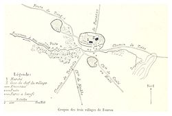
Fama is a small town and rural commune in the Cercle of Sikasso in the Sikasso Region of southern Mali. The commune covers an area of 222 square kilometers and includes the town and five villages. In the 2009 census it had a population of 7,960. The town of Fama, the chef-lieu of the commune, is 24 km north of Sikasso.
Blendio is a small town and rural commune in the Cercle of Sikasso in the Sikasso Region of southern Mali. The commune covers an area of 369 square kilometers and includes the town and 13 villages. In the 2009 census it had a population of 18,207. The town of Blendio, the chef-lieu of the commune, is 81 km west-northwest of Sikasso.
Kapolondougou is a rural commune in the Cercle of Sikasso in the Sikasso Region of southern Mali. The commune covers an area of 526 square kilometers and includes 19 villages. In the 2009 census it had a population of 12,605. The main village (chef-lieu) is N'Kourala. It lies 50 km west of Sikasso on the main road, the RN7, linking Sikasso and Bougouni.
Kofan is a rural commune in the Cercle of Sikasso in the Sikasso Region of southern Mali. The commune covers an area of 283 square kilometers and includes a small town and 7 villages. In the 2009 census it had a population of 10,236. The administrative center of the commune, the chef-lieu, is the small town of Kafana. The town is 68 km northwest of Sikasso.