Goundam Circle is a second-level administrative subdivision of the Tombouctou Region in northern Mali. Its administrative center is the town of Goundam, although the most populous commune is that of Tonka. In the 2009 census, the circle had a population of 150,150.
Diré Cercle is an administrative subdivision of the Tombouctou Region of Mali. The administrative center (chef-lieu) is the town of Diré.

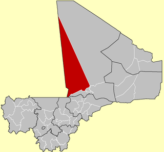
Timbuktu Cercle is an administrative subdivision of the Tombouctou Region of Mali. It is the largest cercle by area in the whole of Mali. The capital lies at the city of Timbuktu. The cercle is divided into Rural and Urban Communes, and below this, quarters/villages. In the 2009 census the cercle had a population of 124,546.

Dangha is a village and commune of the Cercle of Diré in the Tombouctou Region of Mali.
Sareyamou is a village and commune of the Cercle of Diré in the Tombouctou Region of Mali. The commune contains 11 settlements.
Tienkour is a village and rural commune of the Cercle of Diré in the Tombouctou Region of Mali.
Douékiré is a village and commune of the Cercle of Goudam in the Tombouctou Region of Mali.
Doukouria is a village and rural commune of the Cercle of Goudam in the Tombouctou Region of Mali.
Léré is a small town and rural commune of the Cercle of Niafunké in the Tombouctou Region of Mali. The commune covers an area of approximately 1,342 square kilometers and contains the town and 18 villages. In the 2009 census the commune had a population of 16,072.
N'Gorkou is a village and rural commune of the Cercle of Niafunké in the Tombouctou Region of Mali. The commune includes around 54 small settlements.
Soboundou is a commune of the Cercle of Niafunké in the Tombouctou Region of Mali. The administrative center (chef-lieu) is the town of Niafunké.
Adiora is a small village and seat of the commune of Ouinerden in the Cercle of Gourma-Rharous in the Tombouctou Region of Mali.
Madiakoye is a village and seat of the commune of Séréré in the Cercle of Gourma-Rharous in the Tombouctou Region of Mali. The village lies on the right bank of the River Niger, upstream of Gourma-Rharous.
Ber is a village and commune of the Cercle of Timbuktu in the Tombouctou Region of Mali. The village lies 8 km north of the Niger River and 53 km east of Timbuktu. In the 2009 census the commune had a population of 9,128. The commune is mainly sand dunes and extends for 35,280 km2.
Tinguereguif is a rural commune of the Cercle of Diré in the Tombouctou Region of Mali. The administrative center (chef-lieu) is the village of Gari.
Tilemsi is a commune of the Cercle of Goundam in the Tombouctou Region of Mali. The seat lies at Kel Malha. In the 2009 census the commune had a population of 7,296.
Ouinderden is a rural commune of the Cercle of Gourma-Rharous in the Tombouctou Region of Mali. The seat lies at Adiora. The commune contains 28 small villages and in the 2009 census had a population of 6,105, nearly all of whom are nomadic pastoralists.
Salam is a rural commune of the Cercle of Timbuktu in the Tombouctou Region of Mali. The commune contains 26 villages and in the 2009 census had a population of 17,139. The commune is administered from Agouni. The commune includes the oasis village of Araouane.


