Tematagi

Last updated
Tematagi
Tematangi.JPG
NASA picture of Tematagi Atoll
Polynesie francaise collectivity location map.svg
Red pog.svg
Tematagi
Geography
Location Pacific Ocean
Coordinates 21°40′S140°37′W / 21.667°S 140.617°W / -21.667; -140.617
Archipelago Tuamotus
Area61 km2 (24 sq mi) (lagoon)
7.7 km2 (3.0 sq mi) (above water)
Length11.5 km (7.15 mi)
Width7 km (4.3 mi)
Administration
France
Overseas collectivity French Polynesia
Administrative subdivision Tuamotus
Commune Tureia
Demographics
Population58 [1] (2012)
Location of Tematagi Atoll Tematangi - Tuamotus Locator Map.jpg
Location of Tematagi Atoll

Tematagi or Tematangi [2] is an atoll in the southeastern area of the Tuamotu Archipelago, French Polynesia. Tematagi's nearest neighbour is Mururoa, which is located 161 kilometres (100 miles) to the ESE.

Contents

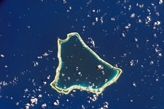
Tematagi is a medium-sized atoll. It measures approximately 11.5 kilometres (7.1 miles) in length and has a maximum width of 7 kilometres (4.3 miles) with a land area of almost 8 square kilometres (3.1 square miles). As its reef completely encloses the deep lagoon, which is 61 square kilometres (24 square miles), there is no navigable pass to enter the lagoon.

There are many relatively large islands on Tematagi's reef, as well as a few small motu. The main village is Tuihana. There were 58 inhabitants on Tematagi in the last census.

History

The first recorded European to visit this atoll was Captain William Bligh on the ship Providence on April 5, 1792. At the time of Bligh's visit, it was uninhabited. Tematagi Atoll appears in some maps as "Bligh's Lagoon Island".

When Frederick Beechey visited Tematagi in 1826 he found inhabitants there. In 1857, the captain of the Julia, coasting along Tematagi Atoll saw armed natives follow the course of his schooner... "clad in many-coloured stuffs".

Population

In 1966, Catholic missionary Father Victor Valleys mentioned in a letter to his bishop that he had planted 135,000 coconut trees on the islands. Teams of workers from neighboring atolls spent three or four months a year at Tematagi harvesting copra. Legally, the atoll did not belong in the public domain of Polynesia: a document states that "the atoll of Tematagi was granted a final license to SCI Tematagi Vanavana in 1974." This SCI was led by Valleys and ceased operation with his death in 1986.[ citation needed ]

A pontoon landing was built at the village of Teakoro, along with a church and administrative buildings. The legal status of the population is not clear since the atoll remains the property of SCI, under the guise of a Catholic Mission. Transactions were even made in 1998 between the vice-president of French Polynesia and Bruno Wan, a pearl prospector. In 2001, the village had 36 residents. The atoll has no airstrip, but, since 2015 there has been a telephone and fax service via satellite.[ citation needed ]

Antipodes of Mecca

Tematagi is the closest landmass to the antipodes of Mecca. This means that the correct direction of Muslim prayer (qibla) varies widely between Tematagi and its neighboring islands. The exact antipodes of Tematagi, however, is a point roughly 4 kilometers northwest of the Jeddah Eastern Forest, a recreation area east of the Saudi-Arabian harbour city of Jeddah (about 55 kilometers from Mecca itself).

This map shows the antipodes of each point on the Earth's surface; the points where the blue and yellow overlap are land antipodes (most land has its antipodes in the ocean). Both Mecca and Tematagi are to the upper left of the center of the map. Antipodes LAEA.png
This map shows the antipodes of each point on the Earth's surface; the points where the blue and yellow overlap are land antipodes (most land has its antipodes in the ocean). Both Mecca and Tematagi are to the upper left of the center of the map.

Administration

Administratively Tematagi belongs to the commune of Tureia, which includes the atolls of Tureia, Fangataufa, Moruroa, Tematagi and Vanavana.

Images & Maps

Related Research Articles

<span class="mw-page-title-main">Moruroa</span> Atoll in French Polynesia

Moruroa, also historically known as Aopuni, is an atoll which forms part of the Tuamotu Archipelago in French Polynesia in the southern Pacific Ocean. It is located about 1,250 kilometres (780 mi) southeast of Tahiti. Administratively Moruroa Atoll is part of the commune of Tureia, which includes the atolls of Tureia, Fangataufa, Tematangi and Vanavana. France undertook nuclear weapon tests between 1966 and 1996 at Moruroa and Fangataufa, causing international protests, notably in 1974 and 1995. The number of tests performed on Moruroa has been variously reported as 175 and 181.

<span class="mw-page-title-main">Fangataufa</span> Atoll in French Polynesia

Fangataufa is an uninhabited coral atoll in the eastern part of the Tuamotu Archipelago in French Polynesia. The atoll has been fully-owned by the French state since 1964. From 1966 to 1996 it was used as a nuclear test site by the French government. In total, 4 atmospheric and 10 underground nuclear explosions were carried out on the atoll.

<span class="mw-page-title-main">Tuamotus</span> Archipelago in French Polynesia

The Tuamotu Archipelago or the Tuamotu Islands are a French Polynesian chain of just under 80 islands and atolls in the southern Pacific Ocean. They constitute the largest chain of atolls in the world, extending over an area roughly the size of Western Europe. Their combined land area is 850 square kilometres. This archipelago's major islands are Anaa, Fakarava, Hao and Makemo.

<span class="mw-page-title-main">Tepoto (North)</span> Atoll in French Polynesia

Tepoto, also known as Te Poto, Toho, or Pukapoto, is a coral island. It is the northwesternmost of the Disappointment Islands, in the Tuamotu Archipelago. Despite being often referred to as "atoll", Tepoto is not a typical Tuamotu atoll, but a single separate island without a lagoon. It is located at the limit of the Tuamotu archipelago; the closest land is Napuka, which lies 16 kilometres to the southeast.

<span class="mw-page-title-main">Ahe</span> Atoll in French Polynesia

Ahe, Ahemaru or Omaru, is a coral atoll in the northern Tuamotu Archipelago, 14 km to the west of Manihi, in French Polynesia. Its ring shape is broken by only a single small passage into the lagoon. It has a land area of approximately 12 km2 and a lagoon area of 138 km2. As of 2012, Ahe Atoll had 553 inhabitants. The only village in Ahe is Tenukupara with approximately 100 inhabitants. It is located on an island in the south side of the Atoll.

<span class="mw-page-title-main">Arutua</span> Atoll in French Polynesia

Arutua, or Ngaru-atua is an atoll in the Tuamotu group in French Polynesia. It is located 40 km SW of Rangiroa. The closest land is Apataki Atoll, only 16 km to the East.

<span class="mw-page-title-main">Fakarava</span> Atoll in French Polynesia

Fakarava, Havaiki-te-araro, Havai'i or Farea is an atoll in the west of the Tuamotu group in French Polynesia. It is the second largest of the Tuamotu atolls. The nearest land is Toau, a coral atoll which lies 14 kilometres to the northwest.

<span class="mw-page-title-main">Fangatau</span> Atoll in French Polynesia

Fangatau, or Nakai-erua, is a small atoll in the Tuamotu group in French Polynesia. The nearest land is Fakahina Atoll, located 72 km to the ESE. This small atoll has an elongated shape. Its length is 8 kilometres, maximum width 3.5 kilometres. It has a total area of 22.2 square kilometres, land area 5.9 km2. Its reef encloses its lagoon completely. Anchorage is difficult. Fangatau Atoll has 135 inhabitants. Teana is the main village.

<span class="mw-page-title-main">Takaroa</span> Atoll in French Polynesia

Takaroa, Taka-roa or Takapua, is an atoll in the Tuamotu group in French Polynesia. It has a length of 27.4 kilometres and a width of 7 km (4 mi); its land area is 20 square kilometres.

<span class="mw-page-title-main">Tatakoto</span> Atoll in French Polynesia

Tatakoto is an atoll in the Tuamotu group in French Polynesia.

<span class="mw-page-title-main">Tikehau</span> Atoll in French Polynesia

Tikehau or Porutu-kai is a coral atoll in the Palliser Islands group, part of the Tuamotu Archipelago in French Polynesia. It is included in the commune of Rangiroa.

<span class="mw-page-title-main">Fakahina</span> Atoll in French Polynesia

Fakahina, or Kaīna, is a small atoll in the north of the Tuamotu group in French Polynesia. The nearest land is Fangatau Atoll, located 72 km to the north-west. Fakahina's length is 9 kilometres and its maximum width 6.3 kilometres. It has a land area of 11.55 square kilometres and a lagoon area of 20 square kilometres. There is no pass connecting the lagoon with the ocean.

<span class="mw-page-title-main">Takume</span> Atoll in French Polynesia

Takume or Pukamaru is an atoll of the Tuamotus chain in French Polynesia, located 790 km northeast of Tahiti and 6 km northeast of Raroia and 128 kilometres to the west of Fangatau.

<span class="mw-page-title-main">Aratika</span> Atoll in French Polynesia

Aratika is an atoll in the Tuamotu group in French Polynesia. The nearest land is Kauehi Atoll, located 35 km to the south east.

<span class="mw-page-title-main">Taenga</span> Atoll in French Polynesia

Taenga, or Taunga-hara, is one of the Tuamotu atolls in French Polynesia. It is located 32 km to the northeast of Makemo Atoll and 27 km to the northwest of Nihiru Atoll.

<span class="mw-page-title-main">Vairaatea</span> Atoll in French Polynesia

Vairaatea is a small atoll of the Tuamotu group in French Polynesia. Geographically Vairaatea Atoll is part of the East-central subgroup of the Tuamotus, which includes Ahunui, Amanu, Fangatau, Hao and Nukutavake. Nukutavake, the closest land, lies 41 kilometres to the east.

<span class="mw-page-title-main">Tuanake</span> Atoll in French Polynesia

Tuanake or Mata-rua-puna is a small uninhabited atoll located in the Tuamotu Archipelago in French Polynesia. It made up the Raevski Islands subgroup with Tepoto Sud and Hiti. It is administratively attached to the municipality of Makemo.

<span class="mw-page-title-main">Katiu</span> Atoll in French Polynesia

Katiu, or Taungataki, is an atoll of the central Tuamotu Archipelago in French Polynesia. It is located 23.5 kilometres west of Makemo Atoll's westernmost point. It measures 27 kilometres in length with a maximum width of 12.5 kilometres. Its total area, including the lagoon is 232.5 square kilometres and a land area of approximately 10 square kilometres. There are many narrow islands on the north-eastern side of its long reef with a total land area of about 3 square kilometres. Its lagoon is connected to the ocean.

<span class="mw-page-title-main">Vanavana</span> Atoll in French Polynesia

Vanavana, Kurataki, or Huataki is an atoll in the southeastern area of the Tuamotu Archipelago, French Polynesia. Vanavana's nearest neighbour is Tureia, which is located 58 kilometres to the east.

<span class="mw-page-title-main">Vahitahi</span> Atoll in French Polynesia

Vahitahi, or Vaitake, is an atoll in the eastern area of the Tuamotu Archipelago, French Polynesia. Vahitahi's nearest neighbour is Akiaki, which is located 41 kilometres to the northwest.

References

  1. "Population". Institut de la statistique de la Polynésie française. Retrieved 9 October 2014.
  2. Board of Geographical Names Site Internet: http://geonames.usgs.gov/foreign/index.html