Vanavana

Last updated
Vanavana
Vanavana.jpeg
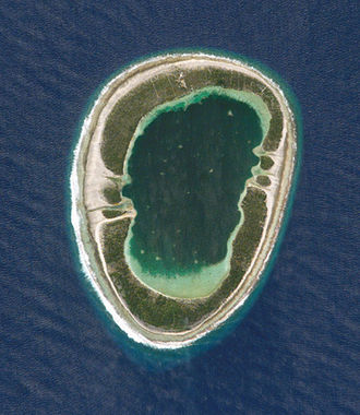
NASA picture of Vanavana Atoll
Polynesie francaise collectivity location map.svg
Red pog.svg
Vanavana
Geography
Location Pacific Ocean
Coordinates 20°47′S139°10′W / 20.783°S 139.167°W / -20.783; -139.167 Coordinates: 20°47′S139°10′W / 20.783°S 139.167°W / -20.783; -139.167
Archipelago Tuamotus
Area6 km2 (2.3 sq mi) (lagoon)
5 km2 (2 sq mi) (above water)
Length3.5 km (2.17 mi)
Width2.2 km (1.37 mi)
Administration
France
Overseas collectivity French Polynesia
Administrative subdivision Tuamotus
Commune Tureia
Demographics
PopulationUninhabited [1] (2012)

Vanavana, Kurataki, or Huataki is an atoll in the southeastern area of the Tuamotu Archipelago, French Polynesia. Vanavana's nearest neighbour is Tureia, which is located 58 kilometres (36 miles) to the east. [2] [3] [4]

Contents

Vanavana is a small oval-shaped atoll. It measures approximately 3.5 kilometres (2.2 miles) in length, has a maximum width of 2.2 kilometres (1.4 miles) and a land area of approximately 5 square kilometres (1.9 square miles). Its reef encloses completely the deep lagoon, which is 6 square kilometres (2.3 square miles). There is one hook-shaped large island in the north and another in the south of its reef.

Vanavana Atoll is uninhabited; however, buildings on the northern end of the island are present.

History

The first recorded European to arrive at Vanavana was British mariner Captain Frederick Beechey in 1826. He named this atoll "Barrow Island", after Sir John Barrow. [5]

Administration

Administratively Vanavana Atoll belongs to the commune of Tureia, which includes the atolls of Tureia, Fangataufa, Moruroa, Tematangi and Vanavana.

Related Research Articles

Coral Sea Islands

The Coral Sea Islands Territory is an external territory of Australia which comprises a group of small and mostly uninhabited tropical islands and reefs in the Coral Sea, northeast of Queensland, Australia. The only inhabited island is Willis Island. The territory covers 780,000 km2 (301,160 sq mi), most of which is ocean, extending east and south from the outer edge of the Great Barrier Reef and includes Heralds Beacon Island, Osprey Reef, the Willis Group and fifteen other reef/island groups. Cato Island is the highest point in the Territory.

Atolls of the Maldives Physical geographic entity

The Maldives are formed by 20 natural atolls, along with a few islands and isolated reefs today which form a pattern stretching from 7 degrees 10′ North to 0 degrees 45′ South. The largest of these atolls is Boduthiladhunmathi, while the atoll containing the most islands is Huvadhu.

Moruroa Atoll in French Polynesia

Moruroa, also historically known as Aopuni, is an atoll which forms part of the Tuamotu Archipelago in French Polynesia in the southern Pacific Ocean. It is located about 1,250 kilometres (780 mi) southeast of Tahiti. Administratively Moruroa Atoll is part of the commune of Tureia, which includes the atolls of Tureia, Fangataufa, Tematangi and Vanavana. France undertook nuclear weapon tests between 1966 and 1996 at Moruroa and Fangataufa, causing international protests, notably in 1974 and 1995. The number of tests performed has been variously reported as 175 and 181.

Fangataufa Atoll in French Polynesia

Fangataufa is a small, low, narrow, coral atoll in the eastern side of the Tuamotu Archipelago. It was formerly known as Cockburn Island. Along with its neighboring atoll, Moruroa, it has been the site of approximately 200 nuclear bomb tests.

Tuamotus Archipelago in French Polynesia

The Tuamotu Archipelago or the Tuamotu Islands, are a French Polynesian chain of just under 80 islands and atolls in the southern Pacific Ocean. They constitute the largest chain of atolls in the world, extending over an area roughly the size of Western Europe. Their combined land area is 850 square kilometres. This archipelago’s major islands are Anaa, Fakarava, Hao and Makemo.

Geography of the British Indian Ocean Territory

The British Indian Ocean Territory (BIOT) is an archipelago of 55 islands in the Indian Ocean, located south of India. It is situated approximately halfway between Africa and Indonesia. The islands form a semicircular group with an open sea towards the east. The largest, Diego Garcia, is located at the southern extreme end. It measures 60 square kilometres (23 sq mi) and accounts for almost three-quarters of the total land area of the territory. Diego Garcia is the only inhabited island and is home to the joint UK-US naval support facility. Other islands within the archipelago include Danger Island, Three Brothers Islands, Nelson Island, and Peros Banhos, as well as the island groups of the Egmont Islands, Eagle Islands, and the Salomon Islands.

Tenararo

Tenararo is the smallest atoll in the Acteon Group in the southeastern part of the Tuamotu Islands in French Polynesia. It is administratively a part of the Gambier Islands. It is uninhabited.

St. François Atoll Atoll in the Seychelles

St. François Atoll is one of two atolls of the Alphonse Group in the Seychelles that are part of the Outer Islands.

Tureia Atoll in French Polynesia

Tureia is an atoll in the Tuamotu Archipelago in French Polynesia.

Tematagi Atoll in French Polynesia

Tematagi or Tematangi is an atoll in the southeastern area of the Tuamotu Archipelago, French Polynesia. Tematagi's nearest neighbour is Mururoa, which is located 161 kilometres to the ESE.

Fakarava Atoll in French Polynesia

Fakarava, Havaiki-te-araro, Havai'i or Farea is an atoll in the west of the Tuamotu group in French Polynesia. It is the second largest of the Tuamotu atolls. The nearest land is Toau Atoll, which lies 14 kilometres to the northwest.

Fangatau Atoll in French Polynesia

Fangatau, or Nakai-erua, is a small atoll in the Tuamotu group in French Polynesia. The nearest land is Fakahina Atoll, located 72 km to the ESE. This small atoll has an elongated shape. Its length is 8 kilometres, maximum width 3.5 kilometres. It has a total area of 22.2 square kilometres, land area 5.9 km2. Its reef encloses its lagoon completely. Anchorage is difficult. Fangatau Atoll has 135 inhabitants. Teana is the main village.

Tatakoto Atoll in French Polynesia

Tatakoto is an atoll in the Tuamotu group in French Polynesia.

Namonuito Atoll Pacific atoll of Federated States of Micronesia

Namonuito Atoll, also called Namonweito, Weito, or Magur Islands, is the largest atoll of the Federated States of Micronesia and of the Caroline Islands with a total area of 2,267 square kilometres, unless one considers the still larger Chuuk (Truk) Lagoon as a type of atoll in an early stage of development. In Micronesia, only Kwajalein Atoll of the Marshall Islands is still larger.

Tikehau Atoll in French Polynesia

Tikehau or Porutu-kai is a coral atoll in the Palliser Islands group, part of the Tuamotu Archipelago in French Polynesia. It is included in the commune of Rangiroa.

Takume Atoll in French Polynesia

Takume or Pukamaru is an atoll of the Tuamotus chain in French Polynesia, located 790 km northeast of Tahiti and 6 km northeast of Raroia and 128 kilometres to the west of Fangatau.

Vairaatea Atoll in French Polynesia

Vairaatea is a small atoll of the Tuamotu group in French Polynesia. Geographically Vairaatea Atoll is part of the East-central subgroup of the Tuamotus, which includes Ahunui, Amanu, Fangatau, Hao and Nukutavake. Nukutavake, the closest land, lies 41 kilometres to the east.

Katiu Atoll in French Polynesia

Katiu, or Taungataki, is an atoll of the central Tuamotu Archipelago in French Polynesia. It is located 23.5 kilometres west of Makemo Atoll's westernmost point. It measures 27 kilometres in length with a maximum width of 12.5 kilometres. Its total area, including the lagoon is 232.5 square kilometres and a land area of approximately 10 square kilometres. There are many narrow islands on the north-eastern side of its long reef with a total land area of about 3 square kilometres. Its lagoon is connected to the ocean.

Anuanurunga Atoll in French Polynesia

Anuanurunga is an atoll in French Polynesia, Pacific Ocean. It is part of the Duke of Gloucester Islands, a subgroup of the Tuamotu group. Anuanurunga's nearest neighbor is Nukutepipi, which is located about 22 km (14 mi) to the ESE.

Vahitahi Atoll in French Polynesia

Vahitahi, or Vaitake, is an atoll in the eastern area of the Tuamotu Archipelago, French Polynesia. Vahitahi's nearest neighbour is Akiaki, which is located 41 kilometres to the northwest.

References

  1. "Population". Institut de la statistique de la Polynésie française. Retrieved 22 September 2014.
  2. Vanavana
  3. Map of Vanavana
  4. Atoll names
  5. "History". Archived from the original on 2006-10-10. Retrieved 2006-10-10.