Tepoto Atoll, or Ti Poto, is a small atoll of the Tuamotu Archipelago in French Polynesia. It is located 44 kilometres southwest of Makemo Atoll.
Hereheretue or Hiri-oro is an atoll in French Polynesia, Pacific Ocean. It is the northernmost island of the Duke of Gloucester Islands group, or Îles du Duc de Gloucester, a subgroup of the Tuamotu group. Hereheretue's nearest neighbour is Anuanuraro, which is located about 150 km away. It lies 450 km southwest of Hao and 488 km southeast of Tahiti.

Hikueru, Tiveru, or Te Kārena, is one of the Central Tuamotu atolls. The closest land to Hikueru is Tekokota Atoll, located 22 km to the north.

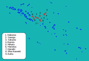
Makemo, Rangi-kemo or Te Paritua, is an inhabited atoll in the Tuamotu archipelago in French Polynesia.

Raroia, or Raro-nuku, is an atoll of the Tuamotus chain in French Polynesia, located 740 km northeast of Tahiti and 6 km southwest of Takume. Administratively it is a part of the commune of Makemo.
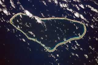
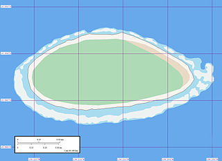
Fakahina, or Kaīna, is a small atoll in the north of the Tuamotu group in French Polynesia. The nearest land is Fangatau Atoll, located 72 km to the north-west. Fakahina's length is 9 kilometres and its maximum width 6.3 kilometres. It has a land area of 11.55 square kilometres and a lagoon area of 20 square kilometres. There is no pass connecting the lagoon with the ocean.

Takume or Pukamaru is an atoll of the Tuamotus chain in French Polynesia, located 790 km northeast of Tahiti and 6 km northeast of Raroia and 128 kilometres to the west of Fangatau.

The Raeffsky Islands or Raevski Islands is a subgroup with just over 3000 people in the Tuamotu group in French Polynesia. They are located roughly in the central area of the main Tuamotu atoll cluster. Named after Nikolay Raevsky, a Russian general of the Napoleonic wars.

Nihiru, or Nikia, is one of the Tuamotu atolls in French Polynesia. It is a relatively small atoll located 49 km to the east of Makemo Atoll and 30 km northeast of Marutea Atoll.
Taenga, or Taunga-hara, is one of the Tuamotu atolls in French Polynesia. It is located 32 km to the northeast of Makemo Atoll and 27 km to the northwest of Nihiru Atoll.

Maria Atoll is an uninhabited small atoll of the Tuamotu group in French Polynesia. It is located in the far southeast of the archipelago, about 72 km (45 mi) southwest from Marutea Sud. Maria's closest neighbour is the small atoll of Matureivavao of the Acteon Group, 56 km (35 mi) to the northwest.

Haraiki is a small atoll of the Tuamotu Archipelago in French Polynesia. It is located 42 km southwest of Marutea Nord.

Hiti, or Hiti-rau-mea, is a small atoll of the Tuamotu Archipelago in French Polynesia. It is located 19 km southwest of Makemo Atoll.

Tuanake or Mata-rua-puna is a small atoll located in the Tuamotu Archipelago in French Polynesia. It made up the Raevski Islands subgroup with Tepoto Sud and Hiti. It is administratively attached to the municipality of Makemo.

Katiu, or Taungataki, is an atoll of the central Tuamotu Archipelago in French Polynesia. It is located 23.5 kilometres west of Makemo Atoll's westernmost point. It measures 27 kilometres in length with a maximum width of 12.5 kilometres. Its total area, including the lagoon is 232.5 square kilometres and a land area of approximately 10 square kilometres. There are many narrow islands on the north-eastern side of its long reef with a total land area of about 3 square kilometres. Its lagoon is connected to the ocean.

Anuanuraro is an atoll in French Polynesia, Pacific Ocean. It is part of the Duke of Gloucester Islands, a subgroup of the Tuamotu group. Anuanuraro's nearest neighbor is Anuanurunga, which is located about 29 km to the southeast.

Nukutepipi, or Nuku-te-pipi is an atoll in French Polynesia, Pacific Ocean. It is part of the Duke of Gloucester Islands, a subgroup of the Tuamotu group. Nukutepipi's nearest neighbor is Anuanurunga, which is located about 22 km to the WNW.

Manuhangi is an atoll of the Tuamotu Archipelago in French Polynesia. It is located 68 km southeast of Nengonengo, 52 km west of Paraoa and 845 km east of Tahiti.

Morane is an uninhabited small isolated atoll of the Tuamotu Archipelago in French Polynesia. It is located 153 km southwest of Maria Est, its closest neighbour. Morane Atoll is the southernmost atoll of the Tuamotus proper. It measures 5.8 km in length, 3.5 km in width and has a land area of 2.85 km2. The lagoon has an area of 11 km2 and has no passes. The islands on its reef are covered with screw pine (Pandanus) and coconut trees.
Akiaki is a low coral atoll in the eastern area of the Tuamotu Archipelago, French Polynesia. Akiaki's nearest neighbor is Vahitahi, which is located 41 km to the southeast.