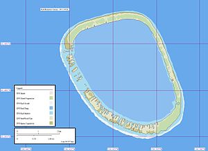
Matureivavao

Last updated
Matureivavao
Matureivavao.JPG
NASA picture of Matureivavao Atoll
Polynesie francaise collectivity location map.svg
Red pog.svg
Matureivavao
Geography
Location Pacific Ocean
Coordinates 21°29′S136°25′W / 21.483°S 136.417°W / -21.483; -136.417
Archipelago Tuamotus
Area18 km2 (6.9 sq mi) (lagoon)
2.5 km2 (1 sq mi) (above water)
Length6.6 km (4.1 mi)
Width4.6 km (2.86 mi)
Administration
France
Overseas collectivity French Polynesia
Administrative subdivision Tuamotus
Commune Gambier Islands
Demographics
PopulationUninhabited [1] (2012)
Map of Matureivavao Atoll. Matureivavao Map.jpg
Map of Matureivavao Atoll.

Matureivavao, or Maturei-vavao [2] is an uninhabited atoll in the Acteon Group in the southeastern part of the Tuamotu Islands. It is the largest atoll within the Acteon Group, and like others in this group, is administratively part of the commune of the Gambier Islands.

Contents

Geography

Matureivavao is about 6.6 km (4.1 mi) long in a NNW-SSE direction and 4.6 km (2.9 mi) wide. It has a land area of 2.5 km2 (1.0 sq mi) and a lagoon area of 18 km2 (6.9 sq mi). It lies 16 km (10 mi) southeast of Tenarunga and 1,390 km (860 mi) from Tahiti. The atoll is high enough to be visible from a considerable distance. It appears as a sandy beach, backed by a line of dark green. In bad weather, the seas sometimes sweep over the reef. There is no entrance to the lagoon.

In some maps, this atoll also appears as "Melbourne".

History

The first recorded sighting of this atoll was made during the Spanish expedition of the Portuguese navigator Pedro Fernández de Quirós on 5 February 1606 under the name Las Cuatro Coronadas (the "four crowned" (by coconut palms)), [3] [4] however, these observations were not fully documented. As such, the first unambiguous approach to the island was made on 14 March 1828 by the explorer Hugh Cuming in his ship Discoverer captained by Samuel Grimwood. The next sighting was in 1833 by navigator Thomas Ebrill on his merchant vessel Amphitrite and again in 1837 by Lord Edward Russell, commander of HMS Actaeon, the name given to the group. [5] It was previously owned by a man named Captain Nicholas but was redeemed in 1934. [6]

Flora and fauna

After the hurricane in 1983, Matureivavao was entirely replanted with thousands of coconut trees. [7] The atoll is also colonized by the invasive Amaranthaceae Achyranthes aspera var. velutina. [8] It is also one of the few atolls in which rats were never introduced.

See also

Related Research Articles

<span class="mw-page-title-main">Hao (French Polynesia)</span> Atoll in French Polynesia

Hao, or Haorangi, is a large coral atoll in the central part of the Tuamotu Archipelago. It has c. 1000 people living on 35 km2 (14 sq mi). It was used to house the military support base for the nuclear tests on Mururoa. Because of its shape, French explorer Louis Antoine de Bougainville named it "Île de la Harpe".

<span class="mw-page-title-main">Hereheretue</span> Atoll in French Polynesia

Hereheretue or Hiri-oro is an atoll in French Polynesia, Pacific Ocean. It is the northernmost island of the Duke of Gloucester Islands group, or Îles du Duc de Gloucester, a subgroup of the Tuamotu group. Hereheretue's nearest neighbour is Anuanuraro, which is located about 150 km away. It lies 450 km southwest of Hao and 488 km southeast of Tahiti.

<span class="mw-page-title-main">Tenararo</span>

Tenararo is the smallest atoll in the Acteon Group in the southeastern part of the Tuamotu Islands in French Polynesia. It is administratively a part of the Gambier Islands. It is uninhabited.

<span class="mw-page-title-main">Tenarunga</span>

Tenarunga or Tenania, previously Narunga and formerly Minto Island, is a low, wooded atoll in the Acteon Group in the southeastern part of the Tuamotu Islands in French Polynesia. It is administratively a part of the Gambier Islands. The atoll has a population of between 10 and 50 people.

<span class="mw-page-title-main">Vahanga</span>

Vahanga is a small uninhabited atoll part of the Acteon Group in the Tuamotu archipelago, French Polynesia and belongs to the municipality of the Gambier Islands.

<span class="mw-page-title-main">Anaa</span> Atoll in French Polynesia

Anaa, Nganaa-nui is an atoll in the Tuamotu archipelago, in French Polynesia. It is located in the north-west of the archipelago, 350 km to the east of Tahiti. It is oval in shape, 29.5 km in length and 6.5 km wide, with a total land area of 38 km2 and a population of 504. The atoll is made up by eleven small barren islands with deeper and more fertile soil than other atolls in the Tuamotus. The lagoon is shallow, without entrance, and formed by three main basins. Although it does not have any navigable access, the water of the lagoon renews by several small channels that can be crossed walking.

<span class="mw-page-title-main">Amanu</span> Atoll in French Polynesia

Amanu, Timanu, or Karere, is an atoll in the Tuamotu archipelago. Amanu lies at right angles to neighbouring Hao Atoll; this orientation is quite rare for the Tuamotu atolls.

<span class="mw-page-title-main">Raroia</span> Atoll in French Polynesia

Raroia, or Raro-nuku, is an atoll of the Tuamotus chain in French Polynesia, located 740 km northeast of Tahiti and 6 km southwest of Takume. Administratively it is a part of the commune of Makemo.

<span class="mw-page-title-main">Takume</span> Atoll in French Polynesia

Takume or Pukamaru is an atoll of the Tuamotus chain in French Polynesia, located 790 km northeast of Tahiti and 6 km northeast of Raroia and 128 kilometres to the west of Fangatau.

<span class="mw-page-title-main">Faaite</span> Atoll in French Polynesia

Faaite, or Faaiti is an atoll of the Tuamotus in French Polynesia. It is located 60 kilometres to the north of Anaa Atoll. The total surface of the atoll is 227 square kilometres Its dry land area is 8.87 square kilometres. Its length is 28 kilometres and its width 10.5 kilometres. The total population as of 2022 is 440 inhabitants.

<span class="mw-page-title-main">Duke of Gloucester Islands</span>

The Duke of Gloucester Islands is a subgroup of the Tuamotu group in French Polynesia. They are located southeast of Tahiti and south of the main Tuamotu atoll cluster and are rather isolated.

<span class="mw-page-title-main">Acteon Group</span>

The Acteon Group is a rather isolated and uninhabited subgroup in the far southeast of the Tuamotu atoll group in French Polynesia. It is located about 1,400 km (870 mi) east-southeast of Tahiti at latitude: 21° 17' 60 S, longitude: 136° 29' W.

<span class="mw-page-title-main">Vairaatea</span> Atoll in French Polynesia

Vairaatea is a small atoll of the Tuamotu group in French Polynesia. Geographically Vairaatea Atoll is part of the East-central subgroup of the Tuamotus, which includes Ahunui, Amanu, Fangatau, Hao and Nukutavake. Nukutavake, the closest land, lies 41 kilometres to the east.

<span class="mw-page-title-main">Maria Est</span> Atoll in French Polynesia

Maria Atoll is an uninhabited small atoll of the Tuamotu group in French Polynesia. It is located in the far southeast of the archipelago, about 72 km (45 mi) southwest from Marutea Sud. Maria's closest neighbour is the small atoll of Matureivavao of the Acteon Group, 56 km (35 mi) to the northwest.

<span class="mw-page-title-main">Marutea Sud</span> Atoll in French Polynesia

Marutea Atoll, also known as Lord Hood Island, Marutea-i-runga, and Nuku-nui, is an atoll in the far southeast of the Tuamotu group of French Polynesia. It lies in the east-northeast part of the Gambier (commune), about 72 km northeast from Maria Atoll.

<span class="mw-page-title-main">Tauere</span> Atoll in French Polynesia

Tauere Atoll or Taouere, also known as Te Putua, is a small atoll of the central Tuamotu Archipelago in French Polynesia. It is located 85 kilometres northwest of Hao Atoll's westernmost point.

<span class="mw-page-title-main">Anuanuraro</span> Atoll in French Polynesia

Anuanuraro is an atoll in French Polynesia, Pacific Ocean. It is part of the Duke of Gloucester Islands, a subgroup of the Tuamotu group. Anuanuraro's nearest neighbor is Anuanurunga, which is located about 29 km to the southeast.

<span class="mw-page-title-main">Anuanurunga</span> Atoll in French Polynesia

Anuanurunga is an atoll in French Polynesia, Pacific Ocean. It is part of the Duke of Gloucester Islands, a subgroup of the Tuamotu group. Anuanurunga's nearest neighbor is Nukutepipi, which is located about 22 km (14 mi) to the ESE.

<span class="mw-page-title-main">Nukutepipi</span> Atoll in French Polynesia

Nukutepipi, or Nuku-te-pipi is an atoll in French Polynesia, Pacific Ocean. It is part of the Duke of Gloucester Islands, a subgroup of the Tuamotu group. Nukutepipi's nearest neighbor is Anuanurunga, which is located about 22 km to the WNW.

<span class="mw-page-title-main">Rekareka</span> Atoll in French Polynesia

Rekareka, Tehuata or Tu-henua, is an atoll of the Tuamotu Archipelago in French Polynesia. It is located in the Centre East of the group, 83 km southeast from Raroia, and lies 70 km NW of Tauere, its nearest neighbor. The shoal water of this small atoll extends 0.8 km seaward from its northern, western, and southern sides, and about 1.3 km from its south-eastern side. Rekareka has no fresh water and is uninhabited.

References

  1. "Population". Institut de la statistique de la Polynésie française. Retrieved 9 October 2014.
  2. Young, J.L. (1899). "Names of the Paumotu Islands, with the old names so far as they are known". Journal of the Polynesian Society. 8 (4): 264–268. Retrieved 7 January 2015.
  3. Brand, Donald D. The Pacific Basin: A History of its Geographical Explorations The American Geographical Society, New York, 1967, p.136.
  4. Kelly, Celsus, O.F.M. La Austrialia del Espiritu Santo. The Journal of Fray Martín de Munilla O.F.M. and other documents relating to the Voyage of Pedro Fernández de Quirós to the South Sea (1605–1606) and the Franciscan Missionary Plan (1617–1627) Cambridge, 1966, p.39,62.
  5. Pacific Island: Eastern-Pacific – Geographical handbook series, James Wightman Davidson and Naval Intelligence Division, editions Naval Intelligence Division, 1945, p.224.
  6. Archaeology of Mangareva and neighboring atolls by Kenneth Pike Emory, editions Kraus, 1971, pp.58–60.
  7. Dahl, prepared by the International Union for Conservation of Nature and Natural Resources, Commission on National Parks and Protected Areas ; in collaboration with the United Nations Environment Programme ; based on the work of Arthur Lyon (1986). Review of the protected areas system in Oceania (Sept. 1986. ed.). Gland, Switzerland: IUCN. ISBN   9782880325091.{{cite book}}: CS1 maint: multiple names: authors list (link)
  8. Florence, Jacques (2004). Flore de la Polynésie française (Reimpr. ed.). Paris: IRD Ed. [u.a.] ISBN   9782709915434.