Ahe, Ahemaru or Omaru, is a coral atoll in the northern Tuamotu Archipelago, 14 km to the west of Manihi, in French Polynesia. Its ring shape is broken by only a single small passage into the lagoon. It has a land area of approximately 12 km2 and a lagoon area of 138 km2. As of 2012, Ahe Atoll had 553 inhabitants. The only village in Ahe is Tenukupara with approximately 100 inhabitants. It is located on an island in the south side of the Atoll.

Vahanga is a small uninhabited atoll part of the Acteon Group in the Tuamotu archipelago, French Polynesia and belongs to the municipality of the Gambier Islands.

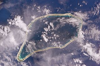
Anaa, Nganaa-nui is an atoll in the Tuamotu archipelago, in French Polynesia. It is located in the north-west of the archipelago, 350 km to the east of Tahiti. It is oval in shape, 29.5 km in length and 6.5 km wide, with a total land area of 38 km2 and a population of 504. The atoll is made up by eleven small barren islands with deeper and more fertile soil than other atolls in the Tuamotus. The lagoon is shallow, without entrance, and formed by three main basins. Although it does not have any navigable access, the water of the lagoon renews by several small channels that can be crossed walking.

Amanu, Timanu, or Karere, is an atoll in the Tuamotu archipelago. Amanu lies at right angles to neighbouring Hao Atoll; this orientation is quite rare for the Tuamotu atolls.

Nukutavake or Nukutuvake is an island in the Tuamotu group in French Polynesia. It lies 1125 km from Tahiti. The closest land is small Pinaki Atoll, located 15 km to the southeast. Vairaatea Atoll lies 38 km to the west of Nukutavake.
Niau is a small atoll in French Polynesia, in the commune of Fakarava. This atoll has a broad fringing reef, a diameter of 8 km and an area of 53 km2.

Arutua, or Ngaru-atua is an atoll in the Tuamotu group in French Polynesia. It is located 40 km SW of Rangiroa. The closest land is Apataki Atoll, only 16 km to the East.
Fakarava, Havaiki-te-araro, Havai'i or Farea is an atoll in the west of the Tuamotu group in French Polynesia. It is the second largest of the Tuamotu atolls. The nearest land is Toau, a coral atoll which lies 14 kilometres to the northwest.

Vairaatea is a small atoll of the Tuamotu group in French Polynesia. Geographically Vairaatea Atoll is part of the East-central subgroup of the Tuamotus, which includes Ahunui, Amanu, Fangatau, Hao and Nukutavake. Nukutavake, the closest land, lies 41 kilometres to the east.

Hiti, or Hiti-rau-mea, is a small atoll of the Tuamotu Archipelago in French Polynesia. It is located 19 km southwest of Makemo Atoll.
Paraoa, Tohora, or Hariri is a small atoll of the central Tuamotu Archipelago in French Polynesia. It is located 76 km south of Hao Atoll's westernmost point. The closest land is Manuhangi Atoll, 52 km to the west.

Anuanuraro is an atoll in French Polynesia, Pacific Ocean. It is part of the Duke of Gloucester Islands, a subgroup of the Tuamotu group. Anuanuraro's nearest neighbor is Anuanurunga, which is located about 29 km to the southeast.
Anuanurunga is an atoll in French Polynesia, Pacific Ocean. It is part of the Duke of Gloucester Islands, a subgroup of the Tuamotu group. Anuanurunga's nearest neighbor is Nukutepipi, which is located about 22 km (14 mi) to the ESE.

Nengonengo is a small atoll of the Tuamotu Archipelago in French Polynesia. It is located 53 km southeast of Ravahere, its closest neighbor, and 100 km southwest of Hao Atoll.

Marokau is an atoll of the Tuamotu Archipelago in French Polynesia. It lies 53 km southeast of Hikueru Atoll and it is separated by a 2 km wide sound from Ravahere, its closest neighbor in the south.

Ahunui or Nga-taumanga is a small atoll of the eastern Tuamotu Archipelago in French Polynesia. It is located 55 km SSE of Paraoa Atoll and 120 km WSW of Vairaatea.

Manuhangi is an atoll of the Tuamotu Archipelago in French Polynesia. It is located 68 km southeast of Nengonengo, 52 km west of Paraoa and 845 km east of Tahiti.

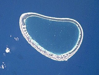
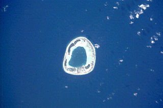
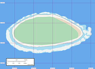
Morane is an uninhabited small isolated atoll of the Tuamotu Archipelago in French Polynesia. It is located 153 km southwest of Maria Est, its closest neighbour. Morane Atoll is the southernmost atoll of the Tuamotus proper. It measures 5.8 km in length, 3.5 km in width and has a land area of 2.85 km2. The lagoon has an area of 11 km2 and has no passes. The islands on its reef are covered with screw pine (Pandanus) and coconut trees.
Akiaki is a low coral atoll in the eastern area of the Tuamotu Archipelago, French Polynesia. Akiaki's nearest neighbor is Vahitahi, which is located 41 km to the southeast.
Nukutavake Airport is an airport serving the village of Tavananui, located on the Nukutavake island, in the Tuamotu group of atolls in French Polynesia, 1,125 kilometres (699 mi) from Tahiti. The closest land is small Pinaki Atoll, located 15 kilometres (9.3 mi) to the southeast. Vairaatea Atoll Atoll lies 38 kilometres (24 mi) to the west of Nukutavake.


