Tatakoto

Last updated
Tatakoto
TatakotoISS004-E-12992.PNG
NASA picture of Tatakoto Atoll
Localizacion de Tatakoto en las Tuamotu.png
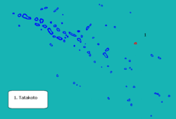
Location of Tatakoto
Tatakoto
Coordinates: 17°21′06″S138°24′05″W / 17.3517°S 138.4013°W / -17.3517; -138.4013 Coordinates: 17°21′06″S138°24′05″W / 17.3517°S 138.4013°W / -17.3517; -138.4013
Country France
Overseas collectivity French Polynesia
Subdivision Îles Tuamotu-Gambier
Area
1
7.3 km2 (2.8 sq mi)
Population
 (2017)
259
  Density35/km2 (92/sq mi)
Time zone UTC−10:00
INSEE/Postal code
98751 /98783
1 French Land Register data, which excludes lakes, ponds, glaciers > 1 km2 (0.386 sq mi or 247 acres) and river estuaries.

Tatakoto is an atoll in the Tuamotu group in French Polynesia.

Contents

Tatakoto is one of the more isolated atolls of the Tuamotus. It is situated in the east of the archipelago, 1,182 kilometres (734 miles) from Tahiti. This atoll is 14 kilometres (9 miles) long and 3.5 kilometres (2 miles) wide. It has one large island and 65 islets separated by numerous channels on the reef surrounding the lagoon. The islands are mostly located on its windward side (south). All the islands are flat, not much higher than the ocean level. Its land area is about 7.3 km2, and the lagoon area is about 20 km2.

The main settlement is Tumukuru, and the total population was 259 in the 2017 census. [1]

History

Tatakoto Atoll was sighted the same day by two Spaniards. In the second expedition of the Águila, the two captains, Domingo de Bonechea and José Andía y Varela, separated when leaving Peru and did not see each other until reaching Tahiti. On 29 October 1774 (the day of Saint Narcissus) the two disembarked on Tatakoto without meeting. They named the island "San Narciso". [2] Historically the island was also known as "d'Augier".

Chronicler José Andía described the atoll as "extremely agreeable to the eyes by being very populated by shrubs." At the beginning of the twentieth century France established a colony and replanted the island with coconut palms, which still cover the island.

Tatakoto Airport was inaugurated in 1979.

Administration

Administratively Tatakoto Atoll has its own commune, which belongs to the Îles Tuamotu-Gambier administrative subdivision of French Polynesia. [3]

Transport

The atoll is served by the Tatakoto Airport ( IATA : TKV, ICAO : NTGO).

Related Research Articles

Napuka Atoll in French Polynesia

Napuka, or Pukaroa, is a small coral atoll in the Disappointment Islands, in the northeastern part of the Tuamotu Archipelago in French Polynesia. It is located only 15 km to the southeast of Tepoto Nord, its nearest neighbor, forming a small group. These two atolls are quite isolated, the nearest land being Fangatau Atoll 170 km to the south.

Rangiroa Atoll in French Polynesia

Rangiroa or Te Kokōta is the largest atoll in the Tuamotus and one of the largest in the world.

Manihi Atoll in French Polynesia

Manihi, or Paeua, is a coral atoll in the Tuamotu Archipelago, part of French Polynesia. It is one of the northernmost of the Tuamotus, located in the King George subgroup. The closest land to Manihi is Ahe Atoll, located 14 km to the west. The population is 650 inhabitants.

Ahe Atoll in French Polynesia

Ahe, Ahemaru or Omaru, is a coral atoll in the northern Tuamotu Archipelago, 14 km to the west of Manihi, in French Polynesia. Its ring shape is broken by only a single small passage into the lagoon. It has a land area of approximately 12 km2 and a lagoon area of 138 km2. As of 2012, Ahe Atoll had 553 inhabitants. The only village in Ahe is Tenukupara with approximately 100 inhabitants. It is located on an island in the south side of the Atoll.

Hao (French Polynesia) Atoll in French Polynesia

Hao, or Haorangi, is a large coral atoll in the central part of the Tuamotu Archipelago. It has c. 1000 people living on 35 km². It was used to house the military support base for the nuclear tests on Mururoa. Because of its shape, French explorer Louis Antoine de Bougainville named it "Île de la Harpe".

Apataki Atoll in French Polynesia

Apataki is a coral atoll in the South Pacific Ocean, territorially part of French Polynesia. It is one of the Palliser Islands, a subgroup of the Tuamotu Archipelago. Apataki is located approximately 370 kilometres northeast of the island of Tahiti, 17 km (11 mi) east of Arutua and 24 km (15 mi) northeast of Kaukura. The island is approximately rectangular; it is 34 km (21 mi) long and 24 km (15 mi) wide. It has a total area of approximately 706 km2 with a land area of approximately 21 km2 (8 sq mi). Two navigable passes enter its wide lagoon.

Anaa Atoll in French Polynesia

Anaa, Nganaa-nui is an atoll in the Tuamotu archipelago, in French Polynesia. It is located in the north-west of the archipelago, 350 km to the east of Tahiti. It is oval in shape, 29.5 km in length and 6.5 km wide, with a total land area of 38 km² and a population of 504. The atoll is made up by eleven small barren islands with deeper and more fertile soil than other atolls in the Tuamotus. The lagoon is shallow, without entrance, and formed by three main basins. Although it does not have any navigable access, the water of the lagoon renews by several small channels that can be crossed walking.

Nukutavake Atoll in French Polynesia

Nukutavake or Nukutuvake is an island in the Tuamotu group in French Polynesia. It lies 1125 km from Tahiti. The closest land is small Pinaki Atoll, located 15 km to the southeast. Vairaatea Atoll lies 38 km to the west of Nukutavake.

Tureia Atoll in French Polynesia

Tureia is an atoll in the Tuamotu Archipelago in French Polynesia.

Makemo Atoll in French Polynesia

Makemo, Rangi-kemo or Te Paritua, is an atoll in the Tuamotu archipelago in French Polynesia.

Arutua Atoll in French Polynesia

Arutua, or Ngaru-atua is an atoll in the Tuamotu group in French Polynesia. It is located 40 km SW of Rangiroa. The closest land is Apataki Atoll, only 16 km to the East.

Fakarava Atoll in French Polynesia

Fakarava, Havaiki-te-araro, Havai'i or Farea is an atoll in the west of the Tuamotu group in French Polynesia. It is the second largest of the Tuamotu atolls. The nearest land is Toau Atoll, which lies 14 kilometres to the northwest.

Fangatau Atoll in French Polynesia

Fangatau, or Nakai-erua, is a small atoll in the Tuamotu group in French Polynesia. The nearest land is Fakahina Atoll, located 72 km to the ESE. This small atoll has an elongated shape. Its length is 8 kilometres, maximum width 3.5 kilometres. It has a total area of 22.2 square kilometres, land area 5.9 km2. Its reef encloses its lagoon completely. Anchorage is difficult. Fangatau Atoll has 135 inhabitants. Teana is the main village.

Takaroa Atoll in French Polynesia

Takaroa, Taka-roa or Takapua, is an atoll in the Tuamotu group in French Polynesia. It has a length of 27.4 kilometres and a width of 7 km (4 mi); its land area is 20 square kilometres.

Tikehau Atoll in French Polynesia

Tikehau or Porutu-kai is a coral atoll in the Palliser Islands group, part of the Tuamotu Archipelago in French Polynesia. It is included in the commune of Rangiroa.

Takume Atoll in French Polynesia

Takume or Pukamaru is an atoll of the Tuamotus chain in French Polynesia, located 790 km northeast of Tahiti and 6 km northeast of Raroia and 128 kilometres to the west of Fangatau.

Faaite Atoll in French Polynesia

Faaite, or Faaiti is an atoll of the Tuamotus in French Polynesia. It is located 60 kilometres to the north of Anaa Atoll. The total surface of the atoll is 227 square kilometres Its dry land area is 8.87 square kilometres. Its length is 28 kilometres and its width 10.5 kilometres. The total population as of 2012 is 401 inhabitants.

Tuanake Atoll in French Polynesia

Tuanake or Mata-rua-puna is a small atoll located in the Tuamotu Archipelago in French Polynesia. He made up the Raevski Islands subgroup with Tepoto Sud and Hiti. It is administratively attached to the municipality of Makemo.

Temoe

Temoe, or Te Moe, is a small atoll of the Gambier Islands in French Polynesia. It is located in the far southeast of the Tuamotu group archipelago. It lies about 37 km southeast from the Gambier Islands and more than 1,700 kilometres southeast from Mataiva, at the other end of the Tuamotu archipelago.

Gambier (commune) Commune in French Polynesia, France

Gambier is a commune of French Polynesia in the archipelago of the Tuamotu Islands. The commune includes the Gambier Islands and several nearby groups of islands, including the Acteon Group, and the nearby atolls of Maria Est, Morane, Marutea Sud and Temoe, mostly uninhabited, and are sometimes mistakenly included among the Gambier Islands themselves. Its population was 1,535 at the 2017 census. Its total land area is 46.0 km2.

References

  1. Répartition de la population en Polynésie française en 2017, Institut de la statistique de la Polynésie française
  2. Corney, Bolton Granvill The quest and occupation of Tahiti by emissaries of Spain during the years 1772-1776, London, 1913, Vol I, p.XLIII, XLVII
  3. Décret n° 2005-1611 du 20 décembre 2005 pris pour l'application du statut d'autonomie de la Polynésie française, Légifrance