
Gran Sasso d'Italia is a massif in the Apennine Mountains of Italy. Its highest peak, Corno Grande, is the highest mountain in the Apennines, and the second-highest mountain in Italy outside the Alps. The mountain lies within Gran Sasso e Monti della Laga National Park.
Santo Stefano is the Italian name of Saint Stephen.

The province of L'Aquila is the largest, most mountainous and least densely populated province of the Abruzzo region of Italy. It comprises about half the landmass of Abruzzo and occupies the western part of the region. It has borders with the provinces of Teramo to the north, Pescara and Chieti to the east, Isernia to the south and Frosinone, Rome and Rieti to the west. Its capital is the city of L'Aquila.

Clusone is an Italian town and comune in the province of Bergamo, Lombardy, Italy. Located in the Val Seriana, it received the honorary title of city on 15 May 1957 with a presidential decree which ratified a Napoleon's promise of the year 1801. It is one of I Borghi più belli d'Italia.

Rocca Grimalda is a village and comune in the province of Alessandria, Piedmont, Northern Italy. It lies in Upper Montferrat, a historical region of Piedmont, and it was built upon a rocky hill on the Orba's left bank, very close to Ovada. The nearest airport is the Cristoforo Colombo Airport in Genoa.

Carapelle Calvisio is a comune and town in the province of L'Aquila in the Abruzzo region of central Italy. It is located in the natural park known as the Gran Sasso e Monti della Laga National Park at 900 metres (3,000 ft) above sea level. It is mostly known as being one of the smallest non-alpine comunes in Italy, with 85 inhabitants as of 31 December 2013. This town is also the smallest community in Abruzzo. It is located directly some kilometers from the historical castle Rocca Calascio.

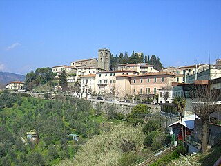
Castel del Monte is a medieval and Renaissance hill town and comune in the province of L'Aquila in northern Abruzzo, Italy. Located in the heart of the Gran Sasso mountain range, the town is set into a steep hillside nestled beneath mountain peaks near the high plain of Campo Imperatore. Castel del Monte sits opposite the ancient mountaintop fortress of Rocca Calascio and faces Monte Sirente in the distance. It is located in the Gran Sasso e Monti della Laga National Park. It is one of I Borghi più belli d'Italia.
Roccacasale is a comune in the Province of L'Aquila in the Abruzzo region of Italy. Built on the slopes of the Monte della Rocca in the central Apennines, the village overlooks the Peligna Valley and the town of Sulmona.

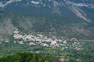
Santo Stefano di Sessanio is a comune and hill town in the province of L'Aquila in the Abruzzo region of southern Italy. Located in the Gran Sasso e Monti della Laga National Park, in the highest region of the Apennines, this medieval hill town sits adjacent to the high plain of Campo Imperatore. It is one of I Borghi più belli d'Italia.

Santo Stefano Belbo is a comune (municipality) in the Province of Cuneo in the Italian region Piedmont, located 60 km (37 mi) southeast of Turin and 60 km (37 mi) northeast of Cuneo.
Montecarlo is a comune (municipality) in the Province of Lucca in the Italian region Tuscany, located about 50 kilometres (31 mi) west of Florence and about 12 kilometres (7 mi) east of Lucca.

Serravalle Pistoiese is a comune (municipality) in the Province of Pistoia in the Italian region Tuscany, located about 35 kilometres (22 mi) northwest of Florence and about 8 kilometres (5 mi) southwest of Pistoia.

Ferentillo is a comune (municipality) in the Province of Terni in the Italian region Umbria, located about 60 km southeast of Perugia and about 12 km northeast of Terni. The comune, located in the valley of the Nera, is divided by the river into the burghs of Matterella and Precetto.

Ficulle is a comune (municipality) in the Province of Terni in the Italian region Umbria, located about 40 km southwest of Perugia and about 60 km northwest of Terni.

Campo Imperatore is a mountain grassland or alpine meadow formed by a high basin shaped plateau located above Gran Sasso massif, the largest plateau of Apennine ridge. Known as "Little Tibet", it is located in Gran Sasso e Monti della Laga National Park, near L'Aquila, Abruzzo, Italy.
The Gran Sasso and Monti della Laga National Park is a natural park in central Italy. Established in 1991, it covers an area of 2,014 square kilometres (778 sq mi), mostly within the provinces of Teramo, L'Aquila, and Pescara in Abruzzo, with small areas in the provinces of Rieti in Lazio and Ascoli Piceno in Marche. The terrain is predominantly mountainous with alpine plains.
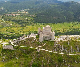
The Castle of Rocca Calascio is a mountaintop fortress or rocca in the municipality of Calascio, in the Province of L'Aquila, Abruzzo, Italy.

Tourism in Abruzzo has become one of the most prosperous sectors in the economy of Abruzzo, and in recent years has seen a remarkable growth attracting numerous tourists from Italy and Europe. According to statistics, in 2021 arrivals totaled 1,330,887. A total of 5,197,765 arrivals were tourists, a figure that puts the region seventeenth among the Italian regions for numbers of tourists per year. A moderate support to tourism is also given to the Abruzzo Airport with many low cost and charter flights connecting the entire region with the rest of Europe.

Assergi is a frazione of the comune of L'Aquila, located about 11 km (6.8 mi) from the capital. With a population of just over 500, it is situated at an altitude of approximately 1,000 meters, below the western slope of the Gran Sasso in a small plain called the Piana di Assergi (Plain of Assergi). Assergi was formerly included in the comune of Camarda, which is directly to its south.


