Sante Marie

Last updated

Sante Marie
Comune di Sante Marie
Sante Marie8857133.jpg
Sante Marie-Stemma.png
Location of Sante Marie
Sante Marie
Italy provincial location map 2016.svg
Red pog.svg
Sante Marie
Location of Sante Marie in Italy
Italy Abruzzo location map.svg
Red pog.svg
Sante Marie
Sante Marie (Abruzzo)
Coordinates: 42°6′16″N13°12′5″E / 42.10444°N 13.20139°E / 42.10444; 13.20139
Country Italy
Region Abruzzo
Province L'Aquila (AQ)
Frazioni Castelvecchio, San Giovanni, Santo Stefano, Scanzano, Tubione, Valle dei Varri
Government
  MayorLorenzo Berardinetti
Area
[1]
  Total40.82 km2 (15.76 sq mi)
Elevation
850 m (2,790 ft)
Population
 (30 November 2017) [2]
  Total1,156
  Density28/km2 (73/sq mi)
Demonym Santemariani
Time zone UTC+1 (CET)
  Summer (DST) UTC+2 (CEST)
Postal code
67067
Dialing code 0863
Patron saint San Quirico, Santa Giulitta, San Nicola, Santa Filomena
Saint day14 July
Website Official website

Sante Marie is a comune and town in the province of L'Aquila, in the Abruzzo region of central Italy

It is served by a station on the Rome-Pescara railroad.

Climate

Climate data for Sante Marie-Tubione, elevation 856 m (2,808 ft), (1951–2000)
MonthJanFebMarAprMayJunJulAugSepOctNovDecYear
Mean daily maximum °C (°F)6.9
(44.4)
7.9
(46.2)
11.2
(52.2)
14.1
(57.4)
19.3
(66.7)
22.9
(73.2)
26.4
(79.5)
26.9
(80.4)
22.3
(72.1)
17.3
(63.1)
11.3
(52.3)
7.3
(45.1)
16.2
(61.1)
Daily mean °C (°F)3.0
(37.4)
3.6
(38.5)
6.4
(43.5)
9.0
(48.2)
13.6
(56.5)
17.0
(62.6)
19.7
(67.5)
20.1
(68.2)
16.3
(61.3)
12.0
(53.6)
7.2
(45.0)
3.7
(38.7)
11.0
(51.8)
Mean daily minimum °C (°F)−0.9
(30.4)
−0.7
(30.7)
1.6
(34.9)
4.0
(39.2)
8.0
(46.4)
11.2
(52.2)
13.1
(55.6)
13.3
(55.9)
10.4
(50.7)
6.8
(44.2)
3.0
(37.4)
0.1
(32.2)
5.8
(42.5)
Average precipitation mm (inches)76.1
(3.00)
77.8
(3.06)
71.0
(2.80)
91.8
(3.61)
70.8
(2.79)
54.2
(2.13)
33.9
(1.33)
42.1
(1.66)
68.5
(2.70)
94.3
(3.71)
142.5
(5.61)
127.5
(5.02)
950.5
(37.42)
Average precipitation days8.48.49.111.09.16.84.44.46.17.910.610.897
Source: Regione Abruzzo [3]

Related Research Articles

Villavallelonga is a village and comune in the Abruzzo region in central Italy. A part of Marsica traditional area, it is included in the Abruzzo, Lazio and Molise National Park.

<span class="mw-page-title-main">Scanno, Abruzzo</span> Comune in Abruzzo, Italy

Scanno is a town and district in the province of L'Aquila, in the Abruzzo region of central Italy. It is one of I Borghi più belli d'Italia.

<span class="mw-page-title-main">Palmoli</span> Comune in Abruzzo, Italy

Palmoli is a comune and town in the province of Chieti, Abruzzo, south-eastern Italy.

<span class="mw-page-title-main">Montazzoli</span> Comune in Abruzzo, Italy

Montazzoli is a comune and town in the Province of Chieti in the Abruzzo region of Italy

<span class="mw-page-title-main">Torino di Sangro</span> Comune in Abruzzo, Italy

Torino di Sangro is a comune and town in the province of Chieti in the Abruzzo region of central Italy.

<span class="mw-page-title-main">Balsorano</span> Comune in Abruzzo, Italy

Balsorano is a comune (municipality) and town in the province of L'Aquila in the Abruzzo region of Italy.

<span class="mw-page-title-main">Barisciano</span> Comune in Abruzzo, Italy

Barisciano, is a comune and town in the province of L'Aquila in the Abruzzo region of central Italy. It is located in the Gran Sasso e Monti della Laga National Park.

<span class="mw-page-title-main">Bisegna</span> Comune in Abruzzo, Italy

Bisegna is a comune and town in the Province of L'Aquila in the Abruzzo region of Italy.

<span class="mw-page-title-main">Capistrello</span> Comune in Abruzzo, Italy

Capistrello is a comune and town in the province of L'Aquila in the Abruzzo region of central-southern Italy. It is located at the border between the upper Liri River valley and the Marsica. Capistrello borders the following municipalities: Avezzano, Canistro, Castellafiume, Filettino (Frosinone), Luco dei Marsi, Scurcola Marsicana and Tagliacozzo.

<span class="mw-page-title-main">Cerchio</span> Comune in Abruzzo, Italy

Cerchio is a comune and town in the province of L'Aquila in the Abruzzo region of southern Italy.

<span class="mw-page-title-main">Goriano Sicoli</span> Comune in Abruzzo, Italy

Goriano Sicoli is a comune and town in the Province of L'Aquila in the Abruzzo region of Italy.

<span class="mw-page-title-main">Massa d'Albe</span> Comune in Abruzzo, Italy

Massa d'Albe is a comune and town in the province of L'Aquila in the Abruzzo region of central Italy. It is part of the Marsica.

<span class="mw-page-title-main">Montereale, Abruzzo</span> Comune in Abruzzo, Italy

Montereale is a comune and town in the province of L'Aquila, in the Abruzzo, region of Italy. It is located in the Gran Sasso e Monti della Laga National Park.

<span class="mw-page-title-main">Ovindoli</span> Comune in Abruzzo, Italy

Ovindoli is a village and comune of the province of L'Aquila in the Abruzzo region of central Italy. Close to Rome, it is a resort for both summer and winter sports, including hiking, biking, equestrian activities and downhill and cross-country skiing.

Pescocostanzo is a comune and town of 1038 inhabitants in the Province of L'Aquila in the Abruzzo region of Italy. It is a tourist destination, attracting people from all over Italy due to its landscape and environment. It is part of the Maiella National Park and is one of I Borghi più belli d'Italia. In winter, Pescocostanzo is a destination for skiers and snowboarders, and has its own ski resort. The towns of Roccaraso and Rivisondoli are close by.

<span class="mw-page-title-main">Rocca di Mezzo</span> Comune in Abruzzo, Italy

Rocca di Mezzo is a comune and town in the Province of L'Aquila, in the Abruzzo region of central Italy.

<span class="mw-page-title-main">Catignano</span> Comune in Abruzzo, Italy

Catignano is a comune and town in the Province of Pescara in the Abruzzo region of Italy

<span class="mw-page-title-main">Isola del Gran Sasso d'Italia</span> Comune in Abruzzo, Italy

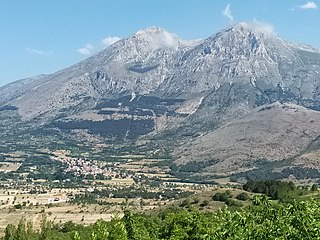
Isola del Gran Sasso d'Italia is a town and comune in province of Teramo in the Abruzzo region of southern Italy. It is located in the Gran Sasso e Monti della Laga National Park. The Gran Sasso mountain is the highest mountain in the Apennine chain in Italy.

<span class="mw-page-title-main">Bellante, Abruzzo</span> Comune in Abruzzo, Italy

Bellante is a town and comune in the province of Teramo, in the Abruzzo region of eastern Italy.

<span class="mw-page-title-main">Nereto</span> Comune in Abruzzo, Italy

Nereto is a town and comune in Teramo province in the Abruzzo region of eastern Italy.

References

  1. "Superficie di Comuni Province e Regioni italiane al 9 ottobre 2011". Italian National Institute of Statistics. Retrieved 16 March 2019.
  2. All demographics and other statistics from the Italian statistical institute (Istat)
  3. "VALORI MEDI CLIMATICI DAL 1951 AL 2000 NELLA REGIONE ABRUZZO" (PDF). Regione Abruzzo. Archived from the original (PDF) on 30 June 2024. Retrieved 30 June 2024.