
The province of L'Aquila is the largest, most mountainous and least densely populated province of the Abruzzo region of Italy. It comprises about half the landmass of Abruzzo and occupies the western part of the region. It has borders with the provinces of Teramo to the north, Pescara and Chieti to the east, Isernia to the south and Frosinone, Rome and Rieti to the west. Its capital is the city of L'Aquila.

Avezzano is a city in the Abruzzo region, province of L'Aquila, Italy. It is the second most populous municipality in the province and the sixth in the region. It is the main commercial, industrial and agricultural centre of the Marsica area, with important high-tech industries and the Fucino Space Centre.

Pescasseroli is a town and comune in the province of L'Aquila, in Southern Abruzzo, central Italy.
Guardiagrele is a town and comune in the province of Chieti, part of the Abruzzo region of central Italy. It is in the foothills of the Maiella mountain at an elevation of around 576 metres (1,890 ft). Its population numbers about 10,000.

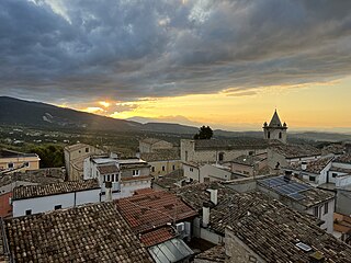
Scanno is a town and district in the province of L'Aquila, in the Abruzzo region of central Italy. It is one of I Borghi più belli d'Italia.

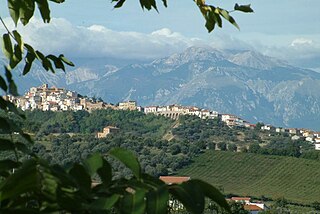
Tagliacozzo is a town and comune in the province of L'Aquila, Abruzzo, central Italy. It is one of I Borghi più belli d'Italia.
Torino di Sangro is a comune and town in the province of Chieti in the Abruzzo region of central Italy.

Balsorano is a comune (municipality) and town in the province of L'Aquila in the Abruzzo region of Italy.
Barrea is a comune in the province of L'Aquila in the Abruzzo region of Italy.
Massa d'Albe is a comune and town in the province of L'Aquila in the Abruzzo region of central Italy. It is part of the Marsica.

Ovindoli is a village and comune of the province of L'Aquila in the Abruzzo region of central Italy. Close to Rome, it is a resort for both summer and winter sports, including hiking, biking, equestrian activities and downhill and cross-country skiing.

Rocca di Mezzo is a comune and town in the Province of L'Aquila, in the Abruzzo region of central Italy.

San Benedetto dei Marsi is a comune and town in the province of L'Aquila in the Abruzzo region of central Italy. It is on the eastern shore of the dried Lake Fucino, 20 kilometres (12 mi) from the remains of another ancient site, Alba Fucens.

Scurcola Marsicana is a comune and town in the province of L'Aquila, in the Abruzzo region of central Italy.
Sant'Eufemia a Maiella is a town and comune in the province of Pescara, Abruzzo, central Italy. It is located in the Maiella National Park in a valley enclosed by the western slopes of the Majella massif, and the northeastern slopes of the Morrone group.

Bellante is a town and comune in the province of Teramo, in the Abruzzo region of eastern Italy.

The Fucine Lake was a large endorheic karst lake between 650 and 680 m above sea level and surrounded by the Monte Sirente-Monte Velino mountain ranges to the north-northeast, Mount Salviano to the west, Vallelonga to the south, and the Valle del Giovenco to the east-southeast. Located in western Abruzzo in central Italy, the town of Avezzano lies to the northwest, Ortucchio to the southeast, and Trasacco to the southwest of the historic lake. Once the third largest lake in Italy after Lake Garda and Lake Maggiore, it was finally drained in 1878.

Prince Don Alessandro Raffaele Torlonia, Prince of Fucino, Prince of Civitella-Cesi, Duke of Ceri was an Italian nobleman of the House of Torlonia. He was the son of Giovanni Torlonia, 1st Prince di Civitella-Cesi (1754–1829).
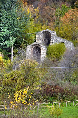
The Tunnels of Claudius consist principally of a 6 km-long tunnel together with several monumental service tunnels which Roman Emperor Claudius had built by 52 AD to partially drain the Fucine Lake in Abruzzo, protecting riparian villages from floods and creating agricultural land. It was a massive engineering project involving 30,000 workmen and slaves who completed it in just 11 years, and considered among the grandest in antiquity. It was the longest tunnel ever built until the inauguration of the Fréjus Rail Tunnel in 1871.
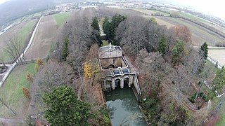
The Fucine Inlet is a monument built on the head of the main emissary of the Fucine Lake in Italy. It is made up of the three-arched bridge of the sluice gates and the about 7-metre-high (23 ft) statue of the Immaculate Conception rising above. It is situated in Borgo Incile, a locality south of the city of Avezzano, in the Fucine plain, Abruzzo, Central Italy. The facility, necessary for the drainage of the Fucine Lake, connects the outer drainage canal to the underground emissary which is served by the system of the Tunnels of Claudius in Mount Salviano. The monument was made in 1876 by architect Carlo Nicola Carnevali.


