
Abruzzo is a region of Southern Italy with an area of 10,763 square km and a population of 1.3 million. It is divided into four provinces: L'Aquila, Teramo, Pescara, and Chieti. Its western border lies 80 km (50 mi) east of Rome. Abruzzo borders the region of Marche to the north, Lazio to the west and north-west, Molise to the south and the Adriatic Sea to the east. Geographically, Abruzzo is divided into a mountainous area in the west, which includes the Gran Sasso d'Italia, and a coastal area in the east with beaches on the Adriatic Sea.

The Province of L'Aquila is the largest, most mountainous and least densely populated province of the Abruzzo region of Southern Italy. It comprises about half the landmass of Abruzzo and occupies the western part of the region. It has borders with the provinces of Teramo to the north, Pescara and Chieti to the east, Isernia to the south and Frosinone, Rome and Rieti to the west. Its capital is the city of L'Aquila.

Avezzano is a city and comune with a population of 40,872 inhabitants, situated in the Abruzzo region, province of L'Aquila, Italy. It is the second most populous municipality in the province and the sixth in the region. Avezzano was documented as an existing urban center in the ninth century. The city was destroyed by the earthquake of 1915. It was rebuilt after the 1944 Allied bombing. The city was decorated with the silver medal for civil merit, an award granted by the Italian Republic.

Celano is a town and comune in the Province of L'Aquila, central Italy, 120 km (75 mi) east of Rome by rail.

Capestrano is a comune and small town with 885 inhabitants (2017), in the Province of L'Aquila, Abruzzo, Italy. It is located in the Gran Sasso e Monti della Laga National Park.

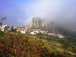
Pacentro is a comune of 1,279 inhabitants of the province of L'Aquila in Abruzzo, Italy. It is a well-preserved historic medieval village located in central Italy, several kilometers from the City of Sulmona about 170 kilometres (110 mi) east of Rome. Pacentro has been nominated as one of the "Borghi più belli d'Italia".
San Giovanni Teatino is a comune and town in the Province of Chieti in the Abruzzo region of Italy. Until 1894 this comune was known as Forcabobolina. Situated on a hill overlooking the valley of the river Pescara (Aterno-Pescara), in recent years the place has undergone an industrial development, especially in the area of Sambuceto. Abruzzo Airport is also located in a portion of the municipal territory, close to the border with Pescara. In fact, the municipality is virtually divided into two, San Giovanni Teatino (Alto), which is the historic village on the hill, and the aforementioned Sambuceto, an ever-growing urban settlement, home to a large shopping area and an important industrialized area.<>
Pizzoferrato is a comune and town in the Province of Chieti in the Abruzzo region of Italy.
Acciano is a comune in the Province of L'Aquila in the Abruzzo region of Italy. The small, medieval village is in the Subequana valley and is a part of the Sirentina Mountain Community.
Barrea is a comune in the province of L'Aquila in the Abruzzo region of Italy.

Goriano Sicoli is a comune and town in the Province of L'Aquila in the Abruzzo region of Italy.
Pereto is a comune and town in the province of L'Aquila in the Abruzzo region of Italy.

Ortona dei Marsi is a comune and town in the province of L'Aquila in the Abruzzo region of central Italy. It is included in traditional area of Marsica. The commune is part of the National Park of Abruzzo, Lazio and Molise. Ortona dei Marsi is situated on 1000 meters above sea level and the mountains that surround the valley reach up to 1,800 meters.

Pescina is a township and comune in the province of L'Aquila, Abruzzo, central Italy. It is a part of the mountain community Valle del Giovenco.

Poggio Picenze is a comune and town in the province of L'Aquila in the Abruzzo region of Italy. Poggio Picenze is a small city with about 1,000 inhabitants. Located on Italy's Highway 17, it is 14 kilometres (9 mi) from the Abruzzese Apennines and about 12 kilometres (7 mi) from the city of L'Aquila. It sits 760 metres (2,490 ft) above sea level and overlooks the Aquila basin. It is also part of the mountain community of Campo Imperatore-Piana Navelli.

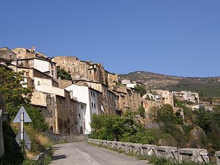
Santo Stefano di Sessanio is a comune and hill town in the province of L'Aquila in the Abruzzo region of southern Italy. Located in the Gran Sasso e Monti della Laga National Park, in the highest region of the Apennines, this medieval hill town sits adjacent to the high plain of Campo Imperatore.

Loreto Aprutino is a comune and town in the Province of Pescara in the Abruzzo region of central Italy.

Borgo Velino is a comune (municipality) in the Province of Rieti in the region Latium, Italy. It is located about 70 kilometres (43 mi) northeast of Rome and about 15 kilometres (9 mi) east of the town Rieti. It has an area of 17.3 square kilometres (6.7 sq mi), and as of 31 December 2010 it had a population of 1,004. Until 1927 Borgo Velino was part of the province of L'Aquila in Abruzzo. It is located near the site of a pre- or early-Roman Sabine village named Viario. Rare ruins of this ancient village, now occupied by a cultivated field, were found near a standing medieval tower. Borgo Velino is the birthplace of Giulio Pezzola, a notorious outlaw of the 17th century.

A rocca is a type of Italian fortified stronghold or fortress, typically located on a hilltop, beneath or on which the inhabitants of a historically clustered village or town might take refuge at times of trouble. Generally under its owners' patronage, the settlement might hope to find prosperity in better times. A rocca might in reality be no grander than a fortified farmhouse. A more extensive rocca would be referred to as a castello.

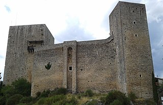
The Castle of Fossa is a Middle Ages castle in Fossa, province of L'Aquila, Abruzzo, southern Italy.


