
Abruzzo, historically known as Abruzzi, is a region of Southern Italy with an area of 10,763 square km and a population of 1.3 million. It is divided into four provinces: L'Aquila, Teramo, Pescara, and Chieti. Its western border lies 80 km (50 mi) east of Rome. Abruzzo borders the region of Marche to the north, Lazio to the west and north-west, Molise to the south and the Adriatic Sea to the east. Geographically, Abruzzo is divided into a mountainous area in the west, which includes the highest massifs of the Apennines, such as the Gran Sasso d'Italia and the Maiella, and a coastal area in the east with beaches on the Adriatic Sea.

The province of Teramo is a province in the Abruzzo region of Italy. Its capital is the city of Teramo. The province has an area of 1,948 square kilometres (752 sq mi), a population of 313,029 (2012), and is subdivided into 47 comuni, see comunes of the province of Teramo. The province of Teramo shares its northern border with the province of Ascoli Piceno in the Marche region, southern and southwestern borders with the province of L'Aquila in the Abruzzo region, and a western border with the province of Rieti in the Lazio region. To the south is the province of Pescara in the Abruzzo region and to the east is the Adriatic Sea.

Monti della Laga is a mountain range in the central Apennines of Italy. Their ruggedness and inaccessibility makes them one of the lesser known areas of the Italian peninsula.

Barete is a comune and town in the province of L'Aquila in the Abruzzo region of Italy. It is located in the Gran Sasso e Monti della Laga National Park.

Barisciano, is a comune and town in the province of L'Aquila in the Abruzzo region of central Italy. It is located in the Gran Sasso e Monti della Laga National Park.

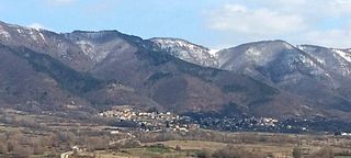
Cagnano Amiterno is a comune and town in the Province of L'Aquila in the Abruzzo region of central Italy.
Capitignano is a comune and town in the province of L'Aquila in the Abruzzo region of Italy. It is located in the Gran Sasso e Monti della Laga National Park. Part of the territory of the municipality falls within the territory of the natural reserve of Lake Campotosto and of the Valle del Tronto.

Carapelle Calvisio is a comune and town in the province of L'Aquila in the Abruzzo region of central Italy. It is located in the natural park known as the Gran Sasso e Monti della Laga National Park at 900 metres (3,000 ft) above sea level. It is mostly known as being one of the smallest non-alpine comunes in Italy, with 85 inhabitants as of 31 December 2013. This town is also the smallest community in Abruzzo. It is located directly some kilometers from the historical castle Rocca Calascio.

Castelvecchio Calvisio is a comune and town in the Province of L'Aquila in the Abruzzo region of Italy. It is located in the Gran Sasso e Monti della Laga National Park.

Montereale is a comune and town in the province of L'Aquila, in the Abruzzo, region of Italy. It is located in the Gran Sasso e Monti della Laga National Park.
Pizzoli is a comune and town in the province of L'Aquila in the Abruzzo region of Italy. It is located in the Gran Sasso e Monti della Laga National Park.

Villa Santa Lucia degli Abruzzi is a little comune and town in the province of L'Aquila in the Abruzzo region of Italy. It is located in the Gran Sasso e Monti della Laga National Park.

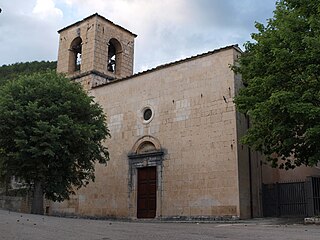
Pescosansonesco is a comune and town in the province of Pescara in the Abruzzo region of Italy. It is 500 metres (1,600 ft) above sea level in the natural park known as the "Gran Sasso e Monti della Laga National Park". Famous for its sanctuary, the village is divided into two parts: the old suburb, "Pescosansonesco Vecchio", which was abandoned in 1944 due to numerous landslides caused by a series of earthquakes, and the new village, "Pescosansonesco Nuovo", built some 3 km (2 mi) away, in the “Ambrosian” region. Before the establishment of Pescosansonesco in the 10th century, there was an ancient settlement, called a pagus. The pre-Roman inhabitants of the area created a sanctuary at Lake Morrone in the 5th century BC.

The Gran Sasso and Monti della Laga National Park is a natural park in central Italy. Established in 1991, it covers an area of 2,014 square kilometres (778 sq mi), mostly within the provinces of Teramo, L'Aquila, and Pescara in Abruzzo, with small areas in the provinces of Rieti in Lazio and Ascoli Piceno in Marche. The terrain is predominantly mountainous with alpine plains.

The Capannelle Pass is a mountain pass in Italy. It sits at an altitude of 1300 meters above sea level in the Province of L'Aquila in Italy's Abruzzo Region. It is located on the Italian State Highway 80 which passes near the Gran Sasso in the Apennines.

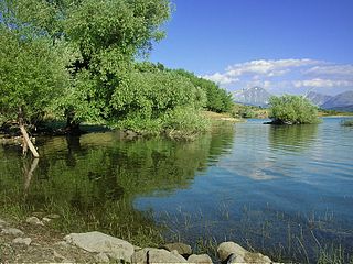
Lago di Campotosto is an artificial lake in Abruzzo, Italy. The reservoir is located at an elevation of 1,313 m and comprises an area of 14 square kilometres. It is located in the natural park known as the "Gran Sasso e Monti della Laga National Park".

Tourism in Abruzzo has become one of the most prosperous sectors in the economy of Abruzzo, and in recent years has seen a remarkable growth attracting numerous tourists from Italy and Europe. According to statistics, in 2021 arrivals totaled 1,330,887. A total of 5,197,765 arrivals were tourists, a figure that puts the region seventeenth among the Italian regions for numbers of tourists per year. A moderate support to tourism is also given to the Abruzzo Airport with many low cost and charter flights connecting the entire region with the rest of Europe.

Assergi is a frazione of the comune of L'Aquila, located about 11 km (6.8 mi) from the capital. With a population of just over 500, it is situated at an altitude of approximately 1,000 meters, below the western slope of the Gran Sasso in a small plain called the Piana di Assergi (Plain of Assergi). Assergi was formerly included in the comune of Camarda, which is directly to its south.
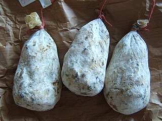
Mortadella di Campotosto is a salami produced in limited quantities in the territory of the comune (municipality) of Campotosto, in the province of L'Aquila, Abruzzo. Mortadella di Campotosto it is listed as a prodotto agroalimentare tradizionale (PAT) by the Italian Ministry of Agricultural, Food and Forestry Policies.
Over the years, Abruzzo has become the most industrialized region of southern Italy and has had significant improvements and growth also at an economic level; the region has reached and surpassed many Italian regions in the specialization of the various industrial sectors and today it is the richest of the regions of Southern Italy.


