San Vincenzo Valle Roveto

Last updated
San Vincenzo Valle Roveto
Comune di San Vincenzo Valle Roveto
San Vincenzo Valle Roveto.jpg
SanVincenzoValleRoveto-Stemma.gif
Location of San Vincenzo Valle Roveto
San Vincenzo Valle Roveto
Italy provincial location map 2016.svg
Red pog.svg
San Vincenzo Valle Roveto
Location of San Vincenzo Valle Roveto in Italy
Italy Abruzzo location map.svg
Red pog.svg
San Vincenzo Valle Roveto
San Vincenzo Valle Roveto (Abruzzo)
Coordinates: 41°50′47″N13°32′12″E / 41.84639°N 13.53667°E / 41.84639; 13.53667
Country Italy
Region Abruzzo
Province L'Aquila (AQ)
Frazioni Castronovo, Morrea, Roccavivi, Rosce, San Giovanni Nuovo, San Giovanni Vecchio, San Vincenzo Superiore, Santa Restituta, Velarde
Government
  MayorGiulio Lancia
Area
[1]
  Total46.04 km2 (17.78 sq mi)
Elevation
388 m (1,273 ft)
Population
 (31 October 2017) [2]
  Total2,302
  Density50/km2 (130/sq mi)
Demonym Sanvincenzesi
Time zone UTC+1 (CET)
  Summer (DST) UTC+2 (CEST)
Postal code
67050
Dialing code 0863
Saint dayJanuary 22
Website Official website

San Vincenzo Valle Roveto is a comune and town in the province of L'Aquila in the Abruzzo region of Italy.

Contents

Geography

The town is located at an altitude of 388 meters above sea level, along the Roveto valley, in Marsica.

History

The medieval village, dating back to around the year one thousand, developed near the church dedicated to St. Vincent martyr, patron saint of the town. [3] The church already depended in the 11th-12th centuries on the Casamari abbey, in the neighboring Latin Valley. The history of the town has always been linked to that of the nearby and more important medieval castle of Morrea, most likely already present in ancient documents dating back to the year 702 with the toponym of Horrea. [4]

Related Research Articles

<span class="mw-page-title-main">Gualdo Tadino</span> Comune in Umbria, Italy

Gualdo Tadino is an ancient town of Italy, in the province of Perugia in northeastern Umbria, on the lower flanks of Monte Penna, a mountain of the Apennines. It is 47 kilometres (29 mi) NE of Perugia.

<span class="mw-page-title-main">Bevagna</span> Comune in Umbria, Italy

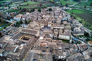
Bevagna is a town and comune in the central part of the Italian province of Perugia (Umbria), in the flood plain of the Topino river.

<span class="mw-page-title-main">Manciano</span> Comune in Tuscany, Italy

Manciano is a town and comune in the southern part of the province of Grosseto, Tuscany, central Italy. It has a population of about 7,200.

<span class="mw-page-title-main">Costa Valle Imagna</span> Comune in Lombardy, Italy

Costa Valle Imagna is a comune counting c 600 inhabitants in the province of Bergamo, in Lombardy, northern Italy. Neighbouring communes are Bedulita, Carenno, Roncola, Sant'Omobono Terme and Torre de' Busi.

<span class="mw-page-title-main">Bibbiena</span> Comune in Tuscany, Italy

Bibbiena is a town and comune in the province of Arezzo, Tuscany (Italy), the largest town in the valley of Casentino. It is located 60 kilometres (37 mi) from Florence, 30 kilometres (19 mi) from Arezzo, 60 kilometres (37 mi) from Siena, and 20 kilometres (12 mi) from the Sanctuary of La Verna. There are approximately 11,833 inhabitants

<span class="mw-page-title-main">Veroli</span> Comune in Lazio, Italy

Veroli is a town and comune in the province of Frosinone, Lazio, central Italy, in the Latin Valley.

<span class="mw-page-title-main">Cannobio</span> Comune in Piedmont, Italy

Cannobio is a town and comune on the river Cannobino and the shore of Lago Maggiore in Piedmont, Italy.

<span class="mw-page-title-main">Maddaloni</span> Comune in Campania, Italy

Maddaloni is a town and comune of Campania, Italy, in the province of Caserta, about 5 kilometres (3 mi) southeast of Caserta, with stations on the railways from Caserta to Benevento and from Caserta to Naples.

<span class="mw-page-title-main">Boville Ernica</span> Comune in Lazio, Italy

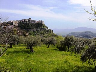
Boville Ernica is a town and comune in the province of Frosinone, Lazio, Italy. It is located over the summit of a steep hill commanding the Liri, Cosa and Sacco valleys. It is one of I Borghi più belli d'Italia.

<span class="mw-page-title-main">Altino, Abruzzo</span> Comune in Abruzzo, Italy

Altino is a comune and town in the province of Chieti in the Abruzzo region of southern Italy. It is located on a rock spur commanding the valley of the Aventino river. The valley is richly cultivated with orchards, fruit, grapes and olives.

<span class="mw-page-title-main">Archi, Abruzzo</span> Comune in Abruzzo, Italy

Archi is a town and comune in the province of Chieti, Abruzzo, southern Italy. It is part of the Valsangro mountain community.

<span class="mw-page-title-main">Canistro</span> Comune in Abruzzo, Italy

Canistro is a comune (municipality) and town in the province of L'Aquila in the Abruzzo region of central Italy.

<span class="mw-page-title-main">Civitella Roveto</span> Comune in Abruzzo, Italy

Civitella Roveto is a comune and town in the province of L'Aquila in the Abruzzo region of central Italy.

<span class="mw-page-title-main">Roccacasale</span> Comune in Abruzzo, Italy

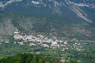
Roccacasale is a comune in the Province of L'Aquila in the Abruzzo region of Italy. Built on the slopes of the Monte della Rocca in the central Apennines, the village overlooks the Peligna Valley and the town of Sulmona.

<span class="mw-page-title-main">Campli</span> Comune in Abruzzo, Italy

Campli is a town and comune in the province of Teramo, in the Abruzzo region of central Italy. It is located in the natural park known as the Gran Sasso e Monti della Laga National Park. It is one of I Borghi più belli d'Italia.

<span class="mw-page-title-main">Laurino</span> Comune in Campania, Italy

Laurino is a town and comune in the province of Salerno in the Campania region of southwestern Italy.

<span class="mw-page-title-main">La Magdeleine</span> Comune in Aosta Valley, Italy

La Magdeleine is a town and comune in the Aosta Valley region of north-west Italy.

Rogliano is a town and comune in the province of Cosenza in the Calabria region of southern Italy. It's located in the Savuto Valley. It was mostly destroyed in a violent earthquake in 1638. The town is 19 kilometers (12 mi) from Cosenza.

<span class="mw-page-title-main">Sant'Ambrogio di Torino</span> Comune in Piedmont, Italy

Sant'Ambrogio di Torino is a comune (municipality) in the Metropolitan City of Turin in the Italian region Piedmont, located about 25 km west of Turin in the Susa Valley.

<span class="mw-page-title-main">Ferentillo</span> Comune in Umbria, Italy

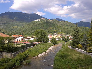
Ferentillo is a comune (municipality) in the Province of Terni in the Italian region Umbria, located about 60 km southeast of Perugia and about 12 km northeast of Terni. The comune, located in the valley of the Nera, is divided by the river into the burghs of Matterella and Precetto.

References

  1. "Superficie di Comuni Province e Regioni italiane al 9 ottobre 2011". Italian National Institute of Statistics. Retrieved 16 March 2019.
  2. "Popolazione Residente al 1° Gennaio 2018". Italian National Institute of Statistics. Retrieved 16 March 2019.
  3. San Vincenzo Valle Roveto. Borghi e storia della Valle Roveto, valleroveto.eu
  4. San Vincenzo Valle Roveto, Il Portale d'Abruzzo