Porlezza | |
|---|---|
| Comune di Porlezza | |
 View of the Lake | |
Location of Porlezza  | |
 Porlezza Location of Porlezza in Italy  Porlezza Porlezza (Lombardy) | |
| Coordinates: 46°2′N9°8′E / 46.033°N 9.133°E | |
| Country | Italy |
| Region | Lombardy |
| Province | Como (CO) |
| Frazioni | Agria, Begna, Cima, Tavordo |
| Government | |
| • Mayor | Sergio Erculiani |
| Area | |
• Total | 18.64 km2 (7.20 sq mi) |
| Elevation | 275 m (902 ft) |
| Population (31 March 2017) [2] | |
• Total | 4,941 |
| • Density | 270/km2 (690/sq mi) |
| Demonym | Porlezzesi o Porlezzini |
| Time zone | UTC+1 (CET) |
| • Summer (DST) | UTC+2 (CEST) |
| Postal code | 22018 |
| Dialing code | 0344 |
| Website | Official website |

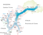
Porlezza is a comune (municipality) on Lake Lugano in the Province of Como in the Italian region Lombardy, located about 60 kilometres (37 mi) north of Milan and about 25 kilometres (16 mi) north of Como.
Porlezza borders the following municipalities: Bene Lario, Carlazzo, Claino con Osteno, Corrido, Lenno, Ossuccio, Ponna, Val Rezzo, Valsolda.
Between 1873 and 1939, Porlezza was linked to Menaggio, on Lake Como, by the Menaggio–Porlezza railway, a steam hauled narrow gauge line built as part of a multi-modal transport link between Menaggio and Luino, on Lake Maggiore. [3]